Today, tropical depression enters the East Sea, strengthening into a storm in the next 24 hours
Báo Tuổi Trẻ•17/09/2024
It is forecasted that today (September 17), the tropical depression will pass Luzon Island (Philippines), enter the East Sea and may strengthen into a storm in the next 24 hours.
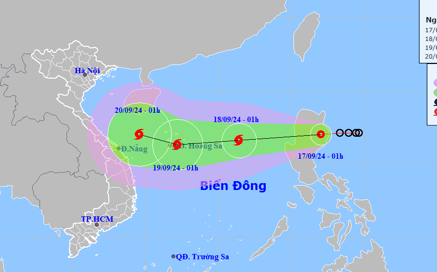
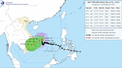
Forecast of location and direction of tropical depression at 1am September 17 - Photo: NCHMF
According to the National Center for Hydro-Meteorological Forecasting, at 1:00 a.m. this morning, the tropical depression was on the mainland of Luzon Island (Philippines), the strongest wind near the center of the tropical depression was level 7 (50-61 km/h), gusting to level 9. It is forecasted that today the tropical depression will pass Luzon Island (Philippines), entering the East Sea. In the next 24 hours, the depression will move rapidly in a west-southwest direction and is likely to strengthen into a storm. If it strengthens into a storm, this will be the 4th storm active in the East Sea in 2024. At 1:00 a.m. tomorrow, the center of the storm will be in the North East Sea, about 420 km east of the Hoang Sa archipelago, with a storm intensity of level 8, gusting to level 10. In the next 24 to 48 hours, the storm will move in a west-southwest direction at a speed of about 15-20 km/h, with the possibility of strengthening. At 1 a.m. on September 19, the storm center was over the Hoang Sa archipelago, the strongest wind near the storm center was level 9, gusting to level 10. In the next 48 to 72 hours, the storm is likely to change direction, moving west-northwest, traveling 10-15km per hour. Due to the influence of the tropical depression, the eastern sea of the North East Sea has strong winds of level 6-7, the area near the storm center has level 8 (62-74km/h), gusting to level 10 (89-102km/h), rough seas. Waves are 2-4m high, increasing to 3-5m from the afternoon of September 17. Ships operating in the above-mentioned dangerous areas are likely to be affected by strong winds and large waves.

![[Photo] Prime Minister Pham Minh Chinh receives President of Cuba's Latin American News Agency](/_next/image?url=https%3A%2F%2Fvphoto.vietnam.vn%2Fthumb%2F1200x675%2Fvietnam%2Fresource%2FIMAGE%2F2025%2F12%2F01%2F1764569497815_dsc-2890-jpg.webp&w=3840&q=75)


Comment (0)