
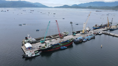
Accordingly, the Chairman of the Provincial People's Committee assigned the Provincial Military Command to preside over and coordinate with relevant units to closely monitor the storm's developments; count and guide boats to move or return to safe shelters; call on boats still operating at sea to urgently return to shore; check tourism safety, review aquaculture cages (especially the number of people on cages) to be ready for evacuation; advise the Provincial People's Committee to decide to limit or prohibit boats from going to sea when necessary.
People's Committees of communes, wards and special zones shall take stock of cages and rafts, proactively evacuate people when storms affect them; review and inspect vulnerable areas (flash floods, landslides, low-lying areas) to evacuate people; inspect and guide the reinforcement of cages and rafts, aquaculture ponds; protect livestock, crops and goods in areas at risk of flooding. At the same time, arrange forces to guard and block off culverts, spillways and deep flooded areas to ensure safety; mobilize people in low-lying areas to proactively raise their assets; inspect riverbanks and roads at risk of landslides, set up blocks; dredge and clear the flow of culverts across the road; cut down trees that are prone to falling; instruct people to brace their houses; arrange forces and means to support evacuation, rescue and relief.
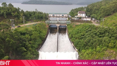
Reservoir management units are on duty seriously, monitoring water levels, checking dam safety, operating reservoirs according to procedures to ensure project safety and limit flooding downstream. Construction investors ensure project safety (especially workers and people in the construction area); reinforce equipment, and be ready to handle incidents. Departments, branches and sectors proactively direct and coordinate to review plans to ensure safety and efficiency. Khanh Hoa Provincial Hydrometeorological Station continues to closely monitor the developments of storms, floods, landslide risks and provide timely information. Media agencies strengthen propaganda and dissemination of knowledge and skills to prevent storms and floods so that people can proactively respond.
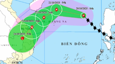
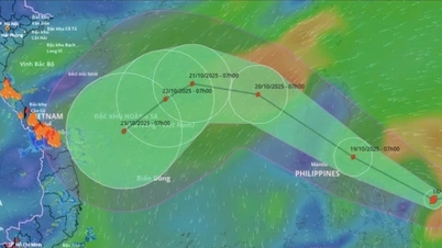
According to the news of the specialized agency, at 4:00 p.m. on October 20, storm No. 12 was about 380 km east-northeast of Hoang Sa special zone, the strongest wind near the storm center was level 9-10 (75-102 km/h), gusting to level 12, moving in the West-Northwest direction and likely to strengthen. It is forecasted that by 4:00 p.m. on October 21, the storm will be in the sea north of Hoang Sa special zone, with wind force of level 11, gusting to level 13.
Due to the storm's influence, the North East Sea area (including Hoang Sa special zone) has strong winds of level 7-8; the area near the storm's eye has strong winds of level 9-11, gusting to level 13; waves 3-5m high, the area near the storm's eye has waves of 5-7m high, and the sea is very rough. All ships and boats operating in the above-mentioned dangerous areas are likely to be affected by storms, whirlwinds, strong winds, and large waves.
On land, from the night of October 22 to October 26, the area from Ha Tinh to Quang Ngai is likely to have widespread heavy rain. The total rainfall in Ha Tinh to Northern Quang Tri and Quang Ngai is about 200-400mm, locally over 500mm; the area from Southern Quang Tri to Da Nang city is generally 500-700mm, locally over 900mm. Heavy rain in the Central region is likely to last until the end of October.
Experts warn of a high risk of flash floods and landslides in mountainous areas, and flooding in low-lying and urban areas. Localities should pay attention to the safe operation of hydroelectric and irrigation reservoirs before, during and after the storm, and prepare response plans for floods on rivers from Quang Tri to Quang Ngai that could reach and exceed alert level 3.
H.D
Source: https://baokhanhhoa.vn/xa-hoi/202510/khan-truong-trien-khai-cac-bien-phap-ung-pho-voi-bao-so-12-d5d46f8/
![[Photo] Prime Minister Pham Minh Chinh meets with Speaker of the Hungarian National Assembly Kover Laszlo](https://vphoto.vietnam.vn/thumb/1200x675/vietnam/resource/IMAGE/2025/10/20/1760970413415_dsc-8111-jpg.webp)
![[Photo] Solemn opening of the 10th Session, 15th National Assembly](https://vphoto.vietnam.vn/thumb/1200x675/vietnam/resource/IMAGE/2025/10/20/1760937111622_ndo_br_1-202-jpg.webp)

![[Photo] Chairman of the Hungarian Parliament visits President Ho Chi Minh's Mausoleum](https://vphoto.vietnam.vn/thumb/1200x675/vietnam/resource/IMAGE/2025/10/20/1760941009023_ndo_br_hungary-jpg.webp)
![[Photo] National Assembly Chairman Tran Thanh Man holds talks with Hungarian National Assembly Chairman Kover Laszlo](https://vphoto.vietnam.vn/thumb/1200x675/vietnam/resource/IMAGE/2025/10/20/1760952711347_ndo_br_bnd-1603-jpg.webp)


![[Photo] The Steering Committee of the 2025 Fall Fair checks the progress of the organization](https://vphoto.vietnam.vn/thumb/1200x675/vietnam/resource/IMAGE/2025/10/20/1760918203241_nam-5371-jpg.webp)


Comment (0)