
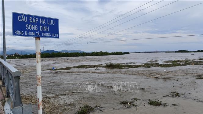
Accordingly, in the past 12 hours on the Dinh Ninh Hoa River upstream at the Duc My hydrological station, the flood is decreasing, at the Ninh Hoa hydrological station, the flood is rising. Specifically, at 8:00 p.m. on November 19, on the Dinh Ninh Hoa Duc My River, it was 18.07 meters, 0.57 meters above the alarm level 3; at the Ninh Hoa hydrological station, it was 6.51 meters, 0.81 meters above the alarm level 3.
At 4:00 p.m. on November 19, the lakes in the North of Khanh Hoa province discharged floodwaters. Da Ban Lake discharged 172.60m3/s, Suoi Trau Lake discharged 190.05m3/s, EaKrongRou Lake discharged 100m3/s. Authorities forecast that if the lakes continue to discharge water combined with the forecasted rainfall in the Dinh Ninh Hoa river basin, in the next 24 hours, the flood on Dinh Ninh Hoa river will continue to rise, the flood peak will reach above alert level 3 from 0.8 to 1.1 meters. In case the flood discharge from the lakes increases, the flood peak on Dinh Ninh Hoa river at Ninh Hoa station may be higher than the historical flood in 1986 (6.58m).
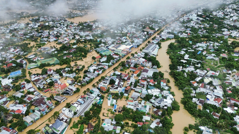
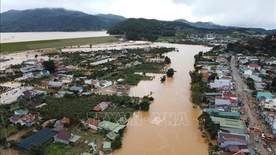
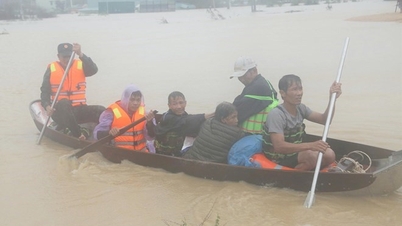
Khanh Hoa Provincial Hydrometeorological Station also warned of flooding in Ninh Hoa, Nam Ninh Hoa, Bac Ninh Hoa, Dong Ninh Hoa, Tan Dinh, Hoa Tri, Hoa Thang wards, etc. The area is likely to continue to spread. The highest level of flooding: from 1.5 to 2.5 meters, in low-lying areas it can be deeper than 3 meters. In addition to flooding, units and localities need to be on guard against the risk of flash floods and landslides that may occur in mountainous areas; safety of reservoirs; flooding in downstream areas, riverside areas, urban areas in the downstream area of Dinh Ninh Hoa River, Khanh Hoa province.
Floods on Cai Nha Trang and Cai Phan Rang rivers have peaked, then receded and risen again. At 9:00 p.m. tonight, floods on the rivers are rising above alert level 3. Authorities also warn that in the next 24 hours at Dong Trang hydrological station and Dien Phu station, they will be above alert level 3, from 1.2 to 2.2 meters. For Cai Phan Rang river water flow at Tan My station, it will be above alert level 3 from 2.5 to 3.5 meters; at Phan Rang station, it will be above alert level 3 from 0.4 to 1.0 meters. Floods are causing inundation in the following wards and communes: Suoi Dau, Suoi Hiep, Dien Khanh, Dien Dien, Dien Lac, Nha Trang, Tay Nha Trang, Bac Nha Trang, Nam Nha Trang; Bac Cam Ranh, Cam Ranh, Nam Cam Ranh, Ba Ngoi, Trung Khanh Vinh; Do Vinh, Bao An, Phan Rang, Phuoc Dinh, Dong Hai..., the scope is likely to continue to spread. Flood level: from 1-2.5 meters, some places flooded deeper than 3 meters.
Regarding the situation of heavy rain and floods that have lasted for the past few days, many areas in Khanh Hoa province have been seriously flooded. To ensure absolute safety for the people, Khanh Hoa Power Joint Stock Company has announced to proactively suspend the power supply in deeply flooded areas with risks of electrical insecurity, and at the same time organize 24/24 hours on duty, direct affiliated units to mobilize maximum human resources, vehicles, materials and equipment, ready to restore power supply as soon as the water recedes and safety conditions are ensured.
Source: https://baotintuc.vn/xa-hoi/khanh-hoa-canh-bao-lu-dac-biet-lon-tren-song-dinh-ninh-hoa-20251119220734548.htm


Comment (0)