
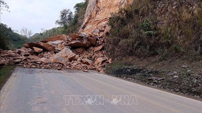
Localized heavy rainfall may cause flash floods on small rivers and streams, landslides on slopes, and flooding in low-lying areas. The risk level for natural disasters due to heavy rain, tornadoes, lightning, and hail is level 1.
Heavy rains in the central, Central Highlands, and southern provinces may cause flooding in urban areas and industrial zones, flash floods on small rivers and streams, and landslides in mountainous regions.
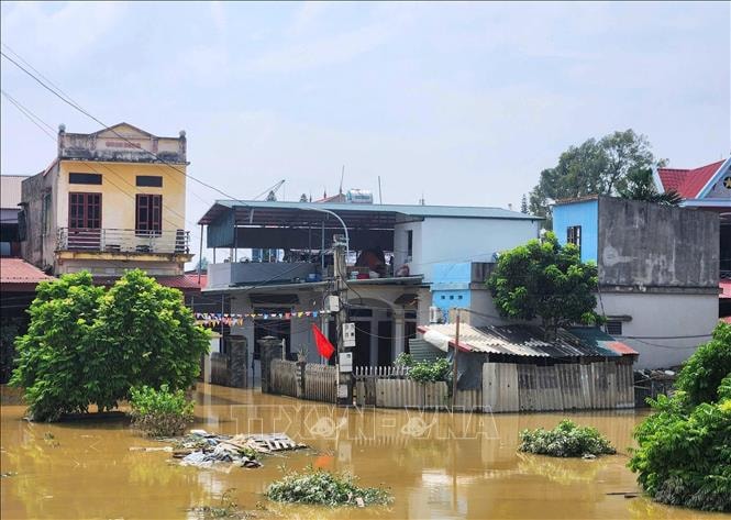
Meanwhile, floodwaters on the Cau and Thuong rivers (Bac Ninh province) are continuing to recede. At 3:00 AM on October 12th, water levels recorded at the Dap Cau station were 6.10 m (approximately 0.20 m below alarm level 3); at the Phu Lang Thuong station, the water level was 6.91 m (approximately 0.61 m above alarm level 3).
Forecast for the next 12 hours: Floods on the Cau River at the Dap Cau station will continue to recede but remain above alarm level 2; floods on the Thuong River at the Phu Lang Thuong station will continue to recede but will still remain above alarm level 3. In the following 12-24 hours, water levels on these two rivers will gradually fall below alarm levels 2 and 3, respectively.
Flooding in Thai Nguyen, Bac Ninh, Lang Son provinces and Hanoi is forecast to continue for the next 1 to 2 days, especially in riverside communes and low-lying areas. Authorities warn of the risk of riverbank erosion, dike collapse, and landslides on slopes; they also note the risk of environmental pollution and disease outbreaks in areas where floodwaters have receded.
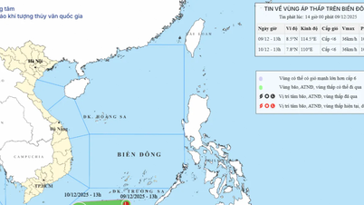
At sea, the low-pressure trough with its axis at approximately 13-16 degrees North latitude continues to be active. Scattered showers and thunderstorms are expected in the central and southern South China Sea, including the Spratly Islands. During the night of October 11th and throughout October 12th, the sea areas from Quang Tri to Ca Mau, from Ca Mau to Kien Giang , the Gulf of Thailand, and the central and southern South China Sea are likely to experience tornadoes, strong gusts of wind (level 6-7), and waves exceeding 2 meters.
The forecasting agency advises vessels operating in these areas to proactively take precautions against strong winds and high waves, ensuring the safety of people and equipment.
Source: https://baohaiphong.vn/lu-tren-song-cau-song-thuong-tiep-tiep-xuong-cham-523308.html

![[Photo] Prime Minister Pham Minh Chinh receives Lao Minister of Education and Sports Thongsalith Mangnormek](/_next/image?url=https%3A%2F%2Fvphoto.vietnam.vn%2Fthumb%2F1200x675%2Fvietnam%2Fresource%2FIMAGE%2F2025%2F12%2F16%2F1765876834721_dsc-7519-jpg.webp&w=3840&q=75)
![[Photo] Prime Minister Pham Minh Chinh receives the Governor of Tochigi Province (Japan)](/_next/image?url=https%3A%2F%2Fvphoto.vietnam.vn%2Fthumb%2F1200x675%2Fvietnam%2Fresource%2FIMAGE%2F2025%2F12%2F16%2F1765892133176_dsc-8082-6425-jpg.webp&w=3840&q=75)
![[Live] 2025 Community Action Awards Gala](/_next/image?url=https%3A%2F%2Fvphoto.vietnam.vn%2Fthumb%2F1200x675%2Fvietnam%2Fresource%2FIMAGE%2F2025%2F12%2F16%2F1765899631650_ndo_tr_z7334013144784-9f9fe10a6d63584c85aff40f2957c250-jpg.webp&w=3840&q=75)

![[Image] Leaked images ahead of the 2025 Community Action Awards gala.](/_next/image?url=https%3A%2F%2Fvphoto.vietnam.vn%2Fthumb%2F1200x675%2Fvietnam%2Fresource%2FIMAGE%2F2025%2F12%2F16%2F1765882828720_ndo_br_thiet-ke-chua-co-ten-45-png.webp&w=3840&q=75)


![[Photo] Prime Minister Pham Minh Chinh attends the Vietnam Economic Forum 2025](https://vphoto.vietnam.vn/thumb/402x226/vietnam/resource/IMAGE/2025/12/16/1765893035503_ndo_br_dsc-8043-jpg.webp)


Comment (0)