
Vinh Phuc has a diverse terrain, with the Tam Dao mountain range in the North stretching from Dao Tru commune (Tam Dao) to Ngoc Thanh commune (Phuc Yen); the Southwest is surrounded by the Red River and the Lo River, creating a terrain that gradually decreases from the Northeast to the Southwest and is divided into three typical ecological regions including the plains, midlands and mountains. Although less directly affected by storms and tropical depressions, due to its geographical location in the Southwest of the Tam Dao mountain range, Vinh Phuc is one of the centers of heavy rain in the country; in the area there are many ponds, lakes, rivers and streams... with potential risks of flooding, flash floods, and landslides.
To ensure the safety of life and property of the State and people in the face of unpredictable natural disasters, in recent years, the province has proactively and synchronously deployed solutions and plans to promptly respond to all natural disaster situations. In particular, promoting the application of technology in hydrometeorological operations has contributed to improving the quality of forecasting work, enhancing proactive response, and minimizing damage from weather, especially natural disasters.
Implementing the plan on the National Comprehensive Program for Natural Disaster Prevention and Control in the area, the province has focused on investing, upgrading, and gradually modernizing the monitoring and information system, improving the capacity for forecasting and warning of hydrometeorology; building a database to support decision-making and directing the response to common types of natural disasters. In addition, the province has issued regulations on coordination in the management of hydrometeorological activities; approved the plan to develop a network of specialized hydrometeorological stations in the province until 2025, with a vision to 2030.
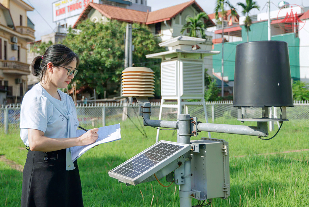
As the standing agency of the Provincial Steering Committee for Natural Disaster Prevention, Control and Search and Rescue, the Department of Agriculture and Environment regularly exploits the natural disaster prevention and control database on the Vietnam Natural Disaster Monitoring System software and uses natural disaster prevention and control applications to update weather conditions and natural disaster warnings; exploits and updates data from specialized rain gauge systems; and increases the installation of automatic rain gauge stations to monitor rainfall in real time. Currently, the province has 15 automatic rain gauge stations that have been integrated into the National Automatic Rain Gauge System, playing an effective role in direction and operation.
In order to promptly provide forecasts and warnings of dangerous hydrometeorological phenomena to serve the work of preventing, combating and mitigating natural disasters, the staff of the Provincial Hydrometeorological Station always upholds the sense of responsibility, promotes the application of digital transformation in monitoring activities, collecting and storing hydrometeorological information and data; gradually shortens the forecasting time, increases the reliability of weather and hydrological bulletins.
Currently, the provincial Hydrometeorological Station has applied many software to support the implementation of professional tasks such as SmartMet meteorological forecasting support system; hydrometeorological data monitoring application; flash flood and landslide warning application; Southeast Asia flash flood warning system; Vrain automatic rain gauge system... In particular, the SmartMet meteorological forecasting support system integrates surface observation data, radar and satellite image products, forecasting models... on the same shared software, creating many favorable conditions for updating, storing, arranging scientifically and in detail information and data according to each time period, helping forecasters provide weather information quickly, promptly and accurately, saving time and human resources.
In addition, the Provincial Hydrometeorological Station also proactively approaches, exploits and integrates advanced international professional forecasting models for the Vietnam region such as GSM (Japan), GFS (USA), IFS (European Center for Medium-Range Forecasting)... In addition, the unit uses a number of models and products such as high-resolution satellite cloud image display software integrated with forecasting model products; Weather Radar; SYNOP map showing meteorological factors at different levels; models in professional products of the National Hydrometeorological Forecasting Center... to help accurately predict long-term and short-term hydrometeorological phenomena.
With the motto of "proactive prevention, timely response", improving forecasting and warning capacity has significantly contributed to improving the effectiveness of direction, management, proactive response, and minimizing damage caused by natural disasters. The complex fluctuations and developments of natural disasters and extreme weather are placing increasing demands on hydrometeorological forecasting.
To improve the capacity of forecasting and responding to natural disasters, the province continues to direct the promotion of digital transformation, the application of artificial intelligence in forecasting and warning technology of natural disasters, ensuring timeliness and accuracy, especially long-term forecasting technology, rain forecasting, and detailed flood warning. At the same time, continue to direct the review and increase the installation of additional automatic rain and flood warning stations in real time; upgrade the hydrometeorological database, ensure smooth, synchronous, highly reliable information, consistent with the development process of the 4.0 industrial revolution.
Le Mo
Source: http://baovinhphuc.com.vn/Multimedia/Images/Id/129293/Nang-cao-nang-luc-du-bao-va-phong-chong-thien-tai


![[OCOP REVIEW] Tu Duyen Syrup - The essence of herbs from the mountains and forests of Nhu Thanh](https://vphoto.vietnam.vn/thumb/402x226/vietnam/resource/IMAGE/2025/6/5/58ca32fce4ec44039e444fbfae7e75ec)


Comment (0)