
Connecting with Innovation Corridors and Knowledge Corridors
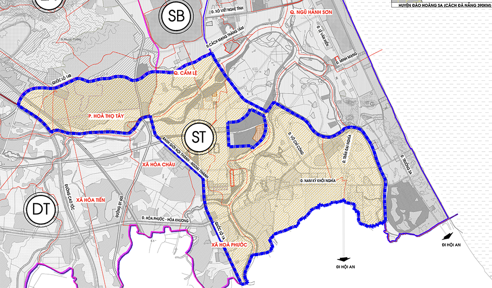
The Innovation zoning plan, scale 1/2,000, is located in the Research Area within the administrative boundaries of Hoa Quy and Hoa Hai wards - Ngu Hanh Son district, Hoa Xuan, Khue Trung, Hoa Tho Tay, Hoa Tho Dong wards - Cam Le district, Hoa Chau, Hoa Phuoc, Hoa Nhon communes - Hoa Vang district with a total area of about 3,770.3 hectares.
In which, the North borders the Airport subdivision and the Green Core Center subdivision; the South borders Quang Nam province; the East borders the Han River and East bank subdivision; the West borders the Development Reserve subdivision.
In terms of nature, the planning area will be a Training Center associated with the University Urban Area, Innovation Center, Software Park, and at the same time, a regional medical center will be added. The area is connected by two main corridors: the Innovation Corridor (connecting training centers, research, high-tech production, etc.) and the Knowledge Corridor (connecting universities and startup and innovation centers, etc.).
The planned area has a population of about 233,000 people by 2030. Of which, the official population is about 202,000 people; the converted population is about 31,000 people.
The southern gateway of the city is the highlight of the zoning plan.
The Innovation Zone according to the general planning project is divided into 02 zones: ST1 and ST2. In the subdivision planning project, it is organized into 23 residential units, 03 residential groups and 06 functional areas.
In which, ST1 area includes: 10 residential units, 02 residential groups and 01 functional area, area of about 1,717.2 hectares; population of about 132,000 people with official population of 112,000 people, converted population of 20,000 people.
ST2 Area includes: 13 residential units, 01 residential group and 05 functional areas, area of about 1,791.9 hectares; population of about 101,000 people with official population of 90,000 people, converted population of 11,000 people.
The highlight of the planning area is the southern gateway of the city, located at the intersection of National Highway 1A and Nam Ky Khoi Nghia Street, bordering Quang Nam province. This is also an important gateway for regional connectivity, goods transit and socio -economic activities in the southern area of the city.
The project identifies 3 highlights of the area that are meaningful in orienting space, creating characteristics and identification, including: Mai Dang Chon - Nam Ky Khoi Nghia intersection area: High-rise commercial service building; Tran Dai Nghia - Nam Ky Khoi Nghia intersection area: High-rise commercial service building;
The Danang University Village area, located in the border area between Danang city and Quang Nam province, is a typical functional area, a multidisciplinary and multi-fieldeducation and training and scientific research center planned in the direction of a smart and green urban area. In particular, the central area is where university activities, public service works and common utilities are operated. Functional areas including university campuses, research centers, startup centers, office areas, dormitories, housing and commerce will be integrated into the university campus, creating an interactive environment, stimulating exchange and creativity.
The central area of the research subdivision is adjacent to Tran Dai Nghia, Vo Chi Cong, Mai Dang Chon, Man Quang, Cai River and the administrative boundary of Da Nang - Quang Nam, with an area of about 696 hectares.
The central area of the subdivision includes typical spaces such as: University Village located in the border area between Da Nang and Quang Nam, is a typical functional area, a center for education and training, multidisciplinary and multi-field scientific research planned in the direction of a smart urban area, a green urban area; Regional medical center, forming an international hospital to create links with medical universities, medical facilities in the area; Commercial service spaces, mixed residential and service spaces along Nam Ky Khoi Nghia street. Connecting the spaces are main roads, walking paths, neighborhoods and riverside routes.
The Innovation Zone planning prioritizes the construction and upgrading of major traffic routes in the zone, different-level traffic intersections, and a system of technical infrastructure hubs to enhance connectivity between areas, open spaces, public spaces, squares, etc. Prioritize investment in building key projects: University Village Urban Area, Riverside Urban Area Southwest of Cau Do Water Plant, Creative Space Project in Hoa Xuan Ward,... At the same time, invest in building additional social infrastructure works: Hoa Phuoc Wholesale Market, universities, Danang Hospital 2, high-quality general/specialty hospitals,... to serve the community. |
RED ARMY
Source: https://www.danang.gov.vn/web/guest/chinh-quyen/chi-tiet?id=60711&_c=3
![[Photo] Prime Minister Pham Minh Chinh receives the President of Asia-Pacific region of PowerChina Group](https://vphoto.vietnam.vn/thumb/1200x675/vietnam/resource/IMAGE/2025/5/21/0f4f3c2f997b4fdaa44b60aaac103d91)
![[Photo] Determining the pairs in the team semi-finals of the National Table Tennis Championship of Nhan Dan Newspaper](https://vphoto.vietnam.vn/thumb/1200x675/vietnam/resource/IMAGE/2025/5/21/eacbf7ae6a59497e9ae5da8e63d227bf)
![[Photo] Scientific workshop "Building a socialist model associated with socialist people in Hai Phong city in the period of 2025-2030 and the following years"](https://vphoto.vietnam.vn/thumb/1200x675/vietnam/resource/IMAGE/2025/5/21/5098e06c813243b1bf5670f9dc20ad0a)

![[Photo] Prime Minister Pham Minh Chinh receives Rabbi Yoav Ben Tzur, Israeli Minister of Labor](https://vphoto.vietnam.vn/thumb/1200x675/vietnam/resource/IMAGE/2025/5/21/511bf6664512413ca5a275cbf3fb2f65)


Comment (0)