
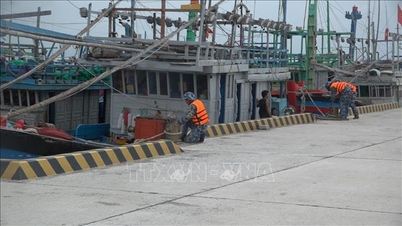
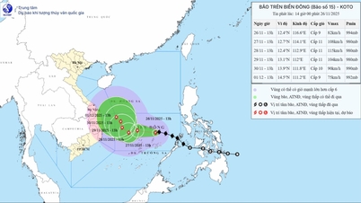
At 11:00 a.m. on November 26, the National Center for Hydro-Meteorological Forecasting reported that the center of storm No. 15 had moved to coordinates of about 12.5 degrees North latitude - 117.1 degrees East longitude, about 330km East Northeast of Song Tu Tay Island. The strongest wind near the center of the storm is level 8-9 (62-88km/h), gusting to level 11. The storm is moving in a West Northwest direction at a speed of 20-25km/h.

According to the meteorological and hydrological agency, from noon on November 26 to 10:00 on November 27, the storm will move in a West-Northwest direction at a speed of 10-15 km/hour and is likely to strengthen. At about 10:00 on November 27, the storm center will be in the middle of the East Sea, about 170 km north of Song Tu Tay Island. From 10:00 on November 27 to 10:00 on November 28, the storm changed direction to West Southwest at a speed of about 5km/h and was likely to strengthen to level 11, gusting to level 14. From 10:00 on November 28 to 10:00 on November 29, the storm changed direction to West Northwest, at a speed of about 5km/h, maintaining level 11, gusting to level 14. At this time, the center of the storm was located in the western sea of the central East Sea, about 180km northwest of Song Tu Tay Island.
. Source: Z.E")
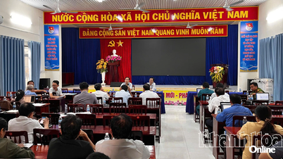
In related developments, on the morning of November 26 in Hanoi, the Department of Hydrometeorology ( Ministry of Agriculture and Environment ) held an online meeting on forecasting storm No. 15. At the meeting, the National Center for Hydrometeorological Forecasting reported that on the night of November 25, storm Koto entered the East Sea and became storm No. 15 with a level 8 intensity, gusting to level 10. Currently, forecast information on the next developments of storm No. 15 is highly dispersed among international meteorological models and agencies.

The National Center for Hydro-Meteorological Forecasting said that from now until November 28, storm No. 15 will move in a West-Northwest direction, then move mainly in a West direction. From November 28 (when the storm moves close to the 113th meridian), the subtropical high pressure will weaken, a low pressure trough will appear in the West wind zone at an altitude of 5,000m, which is likely to impact and change the direction of the storm, so there may be different possibilities regarding the path and impact of storm No. 15 on the seas and mainland of Vietnam.
Mr. Hoang Duc Cuong, Deputy Director of the Department of Hydrometeorology, requested local hydrometeorological stations to increase updating and unifying information according to existing forecasting plans, providing timely information to provinces that are heavily affected by floods such as Quang Ngai, Gia Lai, Dak Lak , Lam Dong, and Khanh Hoa.
Mr. Nguyen Thuong Hien, Director of the Department of Hydrometeorology, requested to ensure the quality of forecast information, especially clarifying the level of impact, affected areas and trying to quantify as much as possible forecast information on wind and wave factors at sea so that people can easily receive and respond, as well as support ships to proactively avoid. The leader of the Department of Hydrometeorology also requested to pay special attention to forecasting rain caused by this storm.
Source: https://www.sggp.org.vn/phai-luong-hoa-cac-du-bao-ve-gio-song-thong-tin-kip-thoi-con-bao-so-15-post825511.html
![[Photo] VinUni students' emotions are sublimated with "Homeland in the Heart: The Concert Film"](/_next/image?url=https%3A%2F%2Fvphoto.vietnam.vn%2Fthumb%2F1200x675%2Fvietnam%2Fresource%2FIMAGE%2F2025%2F11%2F26%2F1764174931822_10-3878-jpg.webp&w=3840&q=75)


![[Photo] Close-up of heavy damage at the school located on the banks of the Ban Thach River](/_next/image?url=https%3A%2F%2Fvphoto.vietnam.vn%2Fthumb%2F1200x675%2Fvietnam%2Fresource%2FIMAGE%2F2025%2F11%2F26%2F1764152130492_ndo_bl_img-8188-8805-jpg.webp&w=3840&q=75)


![[Photo] Opening of the 28th Session of the Hanoi People's Council](https://vphoto.vietnam.vn/thumb/402x226/vietnam/resource/IMAGE/2025/11/26/1764155991133_image.jpeg)


Comment (0)