

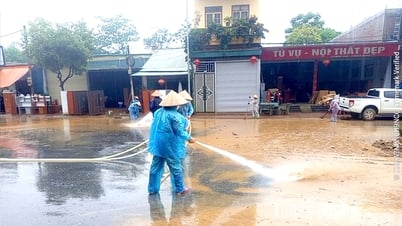
The landslide in Long Hung ward on the morning of May 13 completely collapsed a rural road, affecting people's daily life and travel.
Danger from landslides
Recently, at around 3:00 a.m. on May 13, 2025, in Long Hung ward, O Mon district ( Can Tho city), a riverbank landslide occurred, causing the road to collapse, affecting the travel of local people. The landslide occurred on the inter-regional rural road Long Dinh - Long Thanh, Long Hung ward, with a landslide length of about 46m, completely cutting off the asphalt road, disrupting people's travel. Fortunately, the landslide did not cause any casualties. The functional departments of O Mon district and Long Hung ward were present in time and mobilized rescue forces to erect barriers, erect prohibition signs, warning lights and traffic diversions in the landslide area. The locality has surveyed and expanded another section of the road for people to travel, and reported the landslide situation to the functional departments of O Mon district and Can Tho city for remedial measures.
Ms. Van Thi Be Bay, who lives near the landslide area, said: “While we were sleeping, we heard the sound of the land collapsing along the riverbank. When people came out to see, they discovered that the road had collapsed into the river. This is a road located along the riverbank, so there have been many landslides, affecting local traffic. In this landslide area, signs appeared a few days ago, so local people put up warning posts, thanks to which when the landslide occurred, it did not affect people's lives. We really hope that the city's functional agencies will soon reinforce and fix the landslide to restore the road, making it easier for local people to travel and transport goods..."
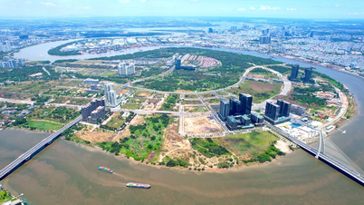
In addition to the above landslide, since the beginning of the year, Can Tho City has also recorded a natural disaster of high tide, the highest peak water level at Can Tho station on Hau River was 1.83m (exceeding alarm level I by 0.03m, occurring at 7:00 p.m. on April 2, 2025). This unusual high tide has flooded many roads in Ninh Kieu district, causing difficulties for people when participating in traffic... Mr. Huynh Thanh Viet, Head of the Irrigation Sub-Department, Chief of Office of the Steering Committee for Civil Defense - Disaster Prevention and Search and Rescue (PTDS-PCTT&TKCN) of Can Tho City, said: "The Office regularly monitors the natural disaster situation in the area and synthesizes the support needs of localities to advise and propose to the city leaders to consider and arrange funding from the city's Natural Disaster Prevention and Control Fund to support households affected by natural disasters to overcome the consequences. In addition, in recent times, many urgent works to prevent landslides on riverbanks, canals and ditches have also been implemented, contributing to overcoming landslides, urban embellishment and stabilizing people's lives...".
According to the Steering Committee for Disaster Prevention and Control and Search and Rescue of Can Tho City, during the transitional season, at the beginning of the rainy season like now (from dry season to rainy season), landslides on riverbanks, canals and ditches often occur. Because, in the dry season, the water level drops, reducing the cohesion of the soil; in the rainy season, the soil is eroded by water, especially the soil along the river and ditches, more rainwater seeps in, increasing gravity and creating flow, which easily leads to landslides. In Can Tho City, from 2010 to 2024, there were over 300 landslides with a length of over 10km. In 2024 alone, landslides on riverbanks, canals and ditches caused quite a lot of damage, occurring 27 times in the districts of Binh Thuy, O Mon, Thot Not, Phong Dien, Co Do, Cai Rang, Thoi Lai, causing 14 houses to collapse, 1 warehouse to collapse, part of the landslide and affecting 35 houses, with no human casualties. The total length affected by the landslide was 911m, with total damage of over 15 billion VND. The City Steering Committee for Disaster Prevention and Control and Search and Rescue promptly supported people to overcome the consequences and soon stabilize their lives.
Coping solutions
According to the Steering Committee for Disaster Prevention and Control and Search and Rescue of Can Tho City, in recent times, riverbank erosion has appeared more and more frequently due to the impact of climate change, changing river flows, during the wet season the water rises, during the dry season the water recedes, reducing the cohesion of the soil, leading to riverbank erosion. Can Tho City is one of the localities heavily affected by this phenomenon, therefore, overcoming riverbank, canal and ditch erosion by construction projects (solid embankments) and non-construction projects (biological embankments) is the most effective and necessary solution for protecting riverbanks, developing urban areas, tourism, etc.
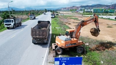
Currently, Can Tho City has been implementing many projects to prevent landslides on rivers. Typically, the emergency construction project to prevent landslides on Cai San canal (Vinh Thanh district, Can Tho city) started construction at the end of 2024 in Vinh Trinh commune, taking advantage of low water levels to speed up construction progress. The Cai San canal emergency embankment project has a length of 912m, with a total investment of nearly 100 billion VND, invested by the Can Tho City Irrigation Department. Up to now, the construction progress of the project has achieved the required volume of work. The investor also requested the construction unit to continue to focus on labor, equipment, and machinery, taking advantage of the conditions during the months when the water level is low to speed up construction progress, completing the project according to the set plan. On April 3, 2025, Can Tho City also started the construction of an emergency embankment to prevent landslides on the O Mon River, through Thoi An Ward (O Mon District) with a total investment of about 130 billion VND. The project is located from opposite Rach Ranh to Rach Tam Vu, in Thoi Trinh B area, Thoi An Ward, O Mon District. The investor is the Can Tho City Irrigation Department. The project has a total estimated cost of about 130 billion VND and is identified as an emergency project to prevent landslides, protect the lives and property of people and the State. The embankment is 650m long, built according to a reinforced concrete structure plan, combined with stone carpet to reinforce the anti-erosion roof. The expected implementation period is from 2025 to 2026, and the capital will be allocated from the city budget according to the 2025 public investment plan.
Mr. Nguyen Ngoc He, Vice Chairman of Can Tho City People's Committee, emphasized: "At this time, the rain has appeared, localities need to proactively organize field inspections to review, update, and identify dangerous areas when rain, storms, tornadoes occur; places with high risk of landslides that endanger people's lives and property... From there, local authorities resolutely organize the evacuation of people in dangerous areas, with high risk of landslides to safe places with the long-term goal of reducing the load, freeing up and restoring the openness of river banks, canals, and ditches. Strengthen inspection and strictly handle cases of construction encroaching on rivers, canals, and ditches that cause blockage of water flow and natural drainage in the area. In addition, localities also propose solutions to overcome landslides in areas that have occurred and are at risk of landslides so that the Steering Committee for Disaster Prevention and Control - PCTT & TKCN can propose to the City People's Committee for timely handling...".
Article and photos: HA VAN
Source: https://baocantho.com.vn/phong-chong-sat-lo-trong-mua-mua-bao-can-giai-phap-can-co-a186498.html

![[Photo] Panorama of the Opening Ceremony of the 43rd Nhan Dan Newspaper National Table Tennis Championship](https://vphoto.vietnam.vn/thumb/1200x675/vietnam/resource/IMAGE/2025/5/19/5e22950340b941309280448198bcf1d9)
![[Photo] Close-up of Tang Long Bridge, Thu Duc City after repairing rutting](https://vphoto.vietnam.vn/thumb/1200x675/vietnam/resource/IMAGE/2025/5/19/086736d9d11f43198f5bd8d78df9bd41)
![[Photo] President Luong Cuong presents the 40-year Party membership badge to Chief of the Office of the President Le Khanh Hai](https://vphoto.vietnam.vn/thumb/1200x675/vietnam/resource/IMAGE/2025/5/19/a22bc55dd7bf4a2ab7e3958d32282c15)

![[Photo] General Secretary To Lam attends the conference to review 10 years of implementing Directive No. 05 of the Politburo and evaluate the results of implementing Regulation No. 09 of the Central Public Security Party Committee.](https://vphoto.vietnam.vn/thumb/1200x675/vietnam/resource/IMAGE/2025/5/19/2f44458c655a4403acd7929dbbfa5039)


![[Photo] Prime Minister Pham Minh Chinh inspects the progress of the National Exhibition and Fair Center project](https://vphoto.vietnam.vn/thumb/1200x675/vietnam/resource/IMAGE/2025/5/19/35189ac8807140d897ad2b7d2583fbae)


![[VIDEO] - Enhancing the value of Quang Nam OCOP products through trade connections](https://vphoto.vietnam.vn/thumb/402x226/vietnam/resource/IMAGE/2025/5/17/5be5b5fff1f14914986fad159097a677)


Comment (0)