
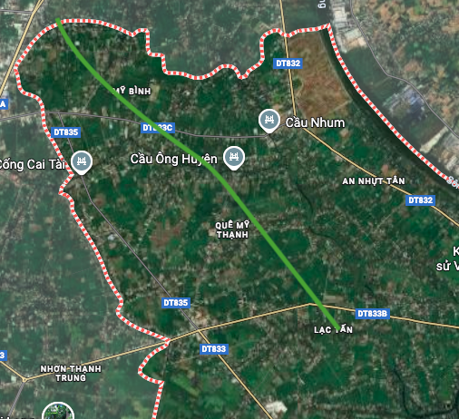
Nhut Tao Commune, Tay Ninh Province is planning to open a new important road about 7.7 km long, crossing Provincial Roads 833C and 833B. According to planning documents, this road section has a starting point near Thien Thanh Temple and an ending point near Tan Duc Bridge, creating a new traffic axis in the commune.
Geographical location and boundaries of Nhut Tao commune
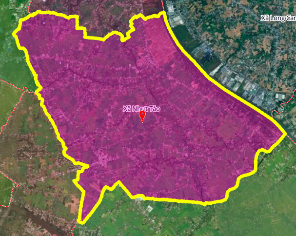
Nhut Tao Commune is one of 96 administrative units at commune and ward level of Tay Ninh province. Geographically, the commune is adjacent to many neighboring localities:
- North: Bordering Binh Duc commune
- East: Bordering Long Giang and My Le communes
- South: Bordering Tan Tru commune
- West: Bordering Thu Thua commune and Tan An ward
New planned route
The new route planned to open in Nhut Tao commune will play an important connecting role, crossing two existing provincial roads, 833C and 833B. The formation of this route will improve the connectivity between residential areas, concentrated residential areas and the main transport system of the area.
Within the commune, the road section is determined to have one end near Thien Thanh Temple, the other end near Tan Duc Bridge. Clearly identifying these geographical landmarks helps people and investors easily visualize the location of the route in the master plan.
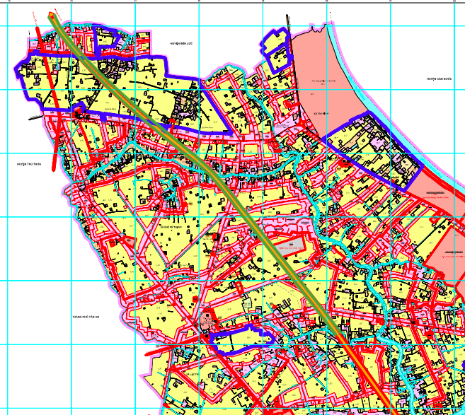
Reference information from relevant planning
The illustrative diagrams in the document are based on the Land Use Planning Adjustment Map for the period 2021 - 2030 of Tan Tru district, Long An province. This is an important reference document to determine the location and route of the new road in Nhut Tao commune.
Important Note
Planning information may change: Routes and construction items in the planning may be adjusted during implementation. People and investors need to follow official information from competent state agencies.
Reference nature: The diagrams and maps illustrated in the article are drawn based on planning documents and are for reference only. For the most accurate information, please refer to the officially approved planning map.
Source: https://baolamdong.vn/quy-hoach-duong-o-xa-nhut-tao-tay-ninh-tuyen-77-km-noi-duong-tinh-833c-833b-404136.html
![[Photo] Visit Hung Yen to admire the "wooden masterpiece" pagoda in the heart of the Northern Delta](/_next/image?url=https%3A%2F%2Fvphoto.vietnam.vn%2Fthumb%2F1200x675%2Fvietnam%2Fresource%2FIMAGE%2F2025%2F11%2F21%2F1763716446000_a1-bnd-8471-1769-jpg.webp&w=3840&q=75)
![[Photo] President Luong Cuong receives Speaker of the Korean National Assembly Woo Won Shik](/_next/image?url=https%3A%2F%2Fvphoto.vietnam.vn%2Fthumb%2F1200x675%2Fvietnam%2Fresource%2FIMAGE%2F2025%2F11%2F21%2F1763720046458_ndo_br_1-jpg.webp&w=3840&q=75)


![[Photo] General Secretary To Lam receives President of the Senate of the Czech Republic Milos Vystrcil](/_next/image?url=https%3A%2F%2Fvphoto.vietnam.vn%2Fthumb%2F1200x675%2Fvietnam%2Fresource%2FIMAGE%2F2025%2F11%2F21%2F1763723946294_ndo_br_1-8401-jpg.webp&w=3840&q=75)
![[Photo] National Assembly Chairman Tran Thanh Man holds talks with President of the Senate of the Czech Republic Milos Vystrcil](/_next/image?url=https%3A%2F%2Fvphoto.vietnam.vn%2Fthumb%2F1200x675%2Fvietnam%2Fresource%2FIMAGE%2F2025%2F11%2F21%2F1763715853195_ndo_br_bnd-6440-jpg.webp&w=3840&q=75)


Comment (0)