
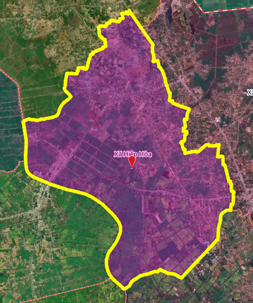
Overview of Hiep Hoa commune, Tay Ninh province
Hiep Hoa commune is one of 96 communes and wards of Tay Ninh province. In terms of geographical location, the north of Hiep Hoa commune borders An Ninh commune; the east borders Hau Nghia commune; the south borders Hoa Khanh and Duc Hue communes; the west borders My Quy and Dong Thanh communes.
Issues to note about planning document sources
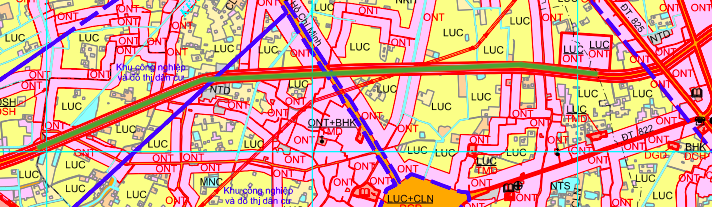
The analysis below is based on the land use planning adjustment map for the period 2021 - 2030 of Duc Hoa district, Long An province. However, the original title refers to Hiep Hoa commune in Tay Ninh province. This is an inconsistency that needs to be clarified. Information users should carefully verify with the competent authority before making any decisions related to real estate or investment.
Analysis of two routes to be opened according to planning
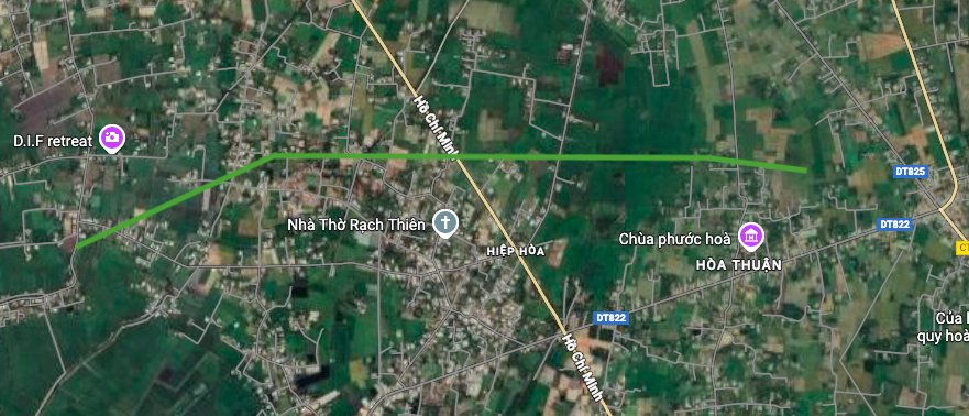
1. Route perpendicular to Ho Chi Minh road (4.2 km)
This route runs perpendicular to the Ho Chi Minh road. Within the commune, one end of the road is near Phuoc Hoa pagoda, the other end is near the Vam Co Dong river, with a total length of about 4.2 km.
This is a route of considerable length, which can create a new traffic axis connecting the spiritual area (Phuoc Hoa Pagoda) with the river system, opening up opportunities for urban space development along this corridor.
2. Route perpendicular to Ho Chi Minh road (1 km)
The second section of road also runs perpendicular to Ho Chi Minh road and has one end on this road, the other end near the pagoda, with a length of about 1 km.
This shorter route has a complementary role, enhancing connectivity from the main traffic axis (Ho Chi Minh road) deep into residential and spiritual areas.
Potential impacts on urban development
Opening these new routes, if properly planned, can bring many benefits:
- Enhanced connectivity: Improve accessibility from Ho Chi Minh Road to residential, spiritual and riverside areas.
- Exploiting land potential: Land plots along the new route can increase in value due to better transport connectivity.
- Spatial development: Creating infrastructure for planned urban space expansion.
Important warnings and recommendations
1. Verifying the location name: Due to the inconsistency between the title (Tay Ninh) and the source document (Long An), information users need to contact directly the Department of Construction, Department of Planning and Architecture or Tay Ninh Provincial People's Committee to verify the information.
2. Check the legality: The above planning maps are for reference only. The official planning must be approved in accordance with legal procedures. People and investors need to request the competent authority to provide official approval documents.
3. Implementation time: The land use plan for the period 2021 - 2030 may be adjusted. The progress of the routes depends on funding sources, investment priorities and actual needs.
4. Investment risks: Do not make decisions on buying, selling or transferring real estate based solely on unverified planning information. It is necessary to fully consider the legal factors, market and feasibility of the project.
Conclude
Information on the planned roads to be opened in Hiep Hoa commune should be considered carefully due to the inconsistency in the location names in the original documents. Although the routes described have the potential for urban development, the lack of official documents from the Tay Ninh provincial management agency is a major limitation. Residents and investors should wait for official information from the competent state agencies before making specific plans.
Note: The diagram in the article is drawn relatively based on the Land Use Planning Adjustment Map for the period 2021 - 2030 of Duc Hoa district, Long An province.
Source: https://baolamdong.vn/quy-hoach-duong-se-mo-o-xa-hiep-hoa-thong-tin-can-lam-ro-404586.html

![[Photo] VinUni students' emotions are sublimated with "Homeland in the Heart: The Concert Film"](/_next/image?url=https%3A%2F%2Fvphoto.vietnam.vn%2Fthumb%2F1200x675%2Fvietnam%2Fresource%2FIMAGE%2F2025%2F11%2F26%2F1764174931822_10-3878-jpg.webp&w=3840&q=75)

![[Photo] Close-up of heavy damage at the school located on the banks of the Ban Thach River](/_next/image?url=https%3A%2F%2Fvphoto.vietnam.vn%2Fthumb%2F1200x675%2Fvietnam%2Fresource%2FIMAGE%2F2025%2F11%2F26%2F1764152130492_ndo_bl_img-8188-8805-jpg.webp&w=3840&q=75)


![[Photo] Opening of the 28th Session of the Hanoi People's Council](https://vphoto.vietnam.vn/thumb/402x226/vietnam/resource/IMAGE/2025/11/26/1764155991133_image.jpeg)


Comment (0)