
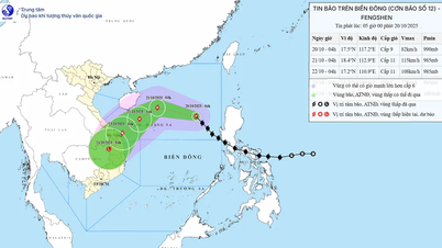
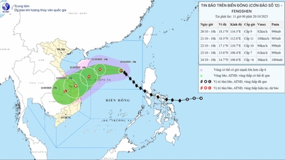
Forecast in the next 24 hours, the storm moves northwest at a speed of about 25 km/hour and tends to strengthen.
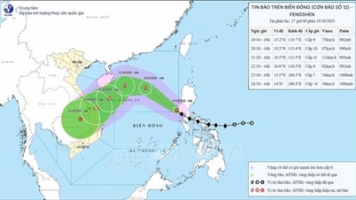
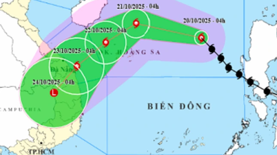
At 4:00 a.m. on October 21, the storm center was at about 18.4 degrees North latitude; 112.9 degrees East longitude, about 180 km North-Northeast of Hoang Sa, with a strong intensity of level 11, gusting to level 13. In the next 48-72 hours, the storm will gradually move slowly in the Southwest direction, traveling about 10 km per hour, then gradually weaken into a low pressure area.
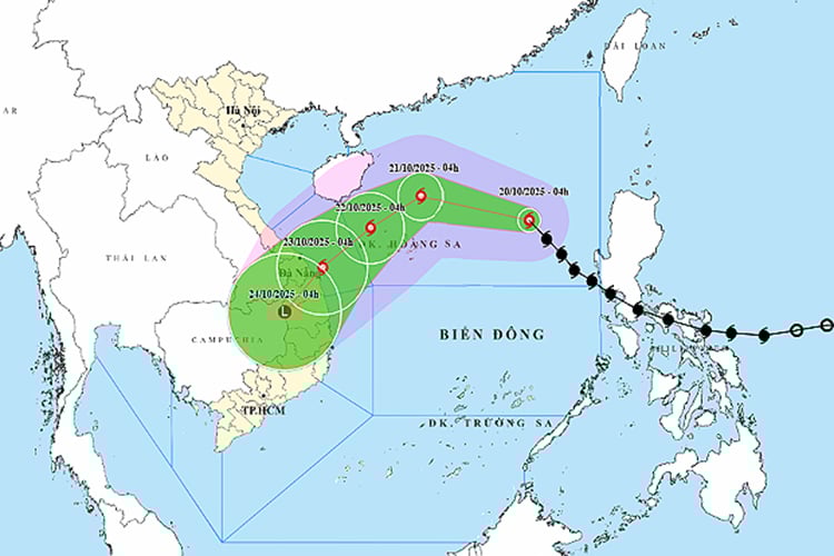
At sea, the North East Sea area (including Hoang Sa sea area) has strong winds of level 7-8, near the storm center strong winds of level 9-11, gusting to level 13; waves 3-5 m high, 5-7 m near the storm center, rough seas. All ships and boats operating in the danger zone need to urgently find safe shelter.
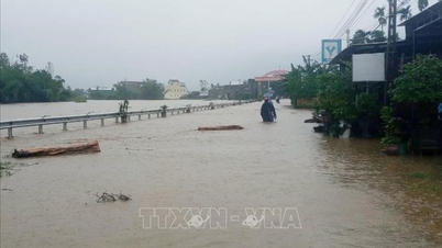
On land, due to the influence of storm circulation combined with cold air and East wind disturbances, from October 22-27, the area from Ha Tinh to Quang Ngai is likely to have widespread heavy rain, some places will have very heavy rain, high risk of flash floods, landslides in mountainous areas and localized flooding in low-lying areas. Rivers from Quang Tri to Quang Ngai are likely to have floods up to alert level 3, some places will exceed alert level 3.
Currently, cold air has affected the Northeast region of the North, at Bach Long Vy station, strong Northeast wind of level 6, gusting to level 7 was recorded. It is forecasted that from October 20-22, cold air will intensify, expanding its influence to the Northern and North Central provinces, then spreading to the Central Central region. From the night of October 20, the North and Thanh Hoa will have cold nights and mornings, the mountainous areas will be cold, the lowest temperature is commonly 19-21 degrees Celsius, the mountainous areas 17-19 degrees Celsius, some places below 16 degrees Celsius.
In Hanoi , there is little rain, cold at night and morning, lowest temperature 19-21 degrees Celsius. In the Gulf of Tonkin, strong northeast wind level 6, gusting to level 7-8, rough sea, waves 2-4 m high.
Experts warn that heavy rain, strong winds and early cold could affect agricultural production, transportation and people's health, especially in the central and northern mountainous regions. Localities need to proactively respond to ensure the safety of people and vehicles.
Weather forecast for regions across the country:
Hanoi capital is cloudy, sunny during the day, no rain at night. Northeast wind level 2-3. Lowest temperature 21-23 degrees Celsius. Highest temperature 29-31 degrees Celsius.
The Northwestern provinces are cloudy with scattered showers; sunny in the afternoon. Light wind. Cold at night. Lowest temperature 19-22 degrees Celsius, in mountainous areas below 16 degrees Celsius. Highest temperature 28-31 degrees Celsius.
The Northeast region is cloudy with some rain; sunny in the afternoon. Northeast wind level 2-3, especially in coastal areas level 3-4. Cold at night. Lowest temperature 19-22 degrees Celsius, in high mountainous areas below 16 degrees Celsius. Highest temperature 28-31 degrees Celsius.
Provinces from Thanh Hoa to Hue are cloudy with rain, moderate rain, locally heavy rain and thunderstorms; Thanh Hoa has some rain, sunny in the afternoon. North to northwest wind level 2-3. During thunderstorms, there is a possibility of tornadoes, lightning and strong gusts. Lowest temperature in the North is 22-24 degrees Celsius; in the South is 24-26 degrees Celsius. Highest temperature is 28-31 degrees Celsius.
South Central Coast region: In the North, it is cloudy with rain, moderate rain, locally heavy rain and thunderstorms; in the South, it is cloudy with scattered showers and thunderstorms, especially in the evening, there are scattered showers and thunderstorms. Northeast wind level 2-3. During thunderstorms, there is a possibility of tornadoes, lightning and strong gusts of wind. Lowest temperature 23-26 degrees Celsius. Highest temperature in the North: 29-31 degrees Celsius; in the South: 30-33 degrees Celsius.
The Central Highlands are cloudy with scattered showers and thunderstorms, with scattered showers and thunderstorms in the South in the late afternoon. Light winds. Thunderstorms may include tornadoes, lightning, hail, and strong gusts of wind. Lowest temperature 19-22 degrees Celsius. Highest temperature 28-31 degrees Celsius.
The South is cloudy with scattered showers and thunderstorms, with scattered showers and thunderstorms in the afternoon and evening, and some places experiencing heavy rain. Light winds. During thunderstorms, there is a possibility of tornadoes, lightning, hail, and strong gusts of wind. Lowest temperature 23-26 degrees Celsius. Highest temperature 31-34 degrees Celsius, some places above 34 degrees Celsius.
Ho Chi Minh City is cloudy with scattered showers and thunderstorms, with scattered showers and thunderstorms in the afternoon and evening, and heavy rain in some places. Light wind. During thunderstorms, there is a possibility of tornadoes, lightning, hail, and strong gusts of wind. Lowest temperature 24-26 degrees Celsius. Highest temperature 32-34 degrees Celsius, with some places above 34 degrees Celsius.
Source: https://baotintuc.vn/xa-hoi/thoi-tiet-ngay-2010-bao-so-12-manh-len-khong-khi-lanh-tang-cuong-canh-bao-mua-lon-20251020060820421.htm
![[Photo] Solemn opening of the 10th Session, 15th National Assembly](https://vphoto.vietnam.vn/thumb/1200x675/vietnam/resource/IMAGE/2025/10/20/1760937111622_ndo_br_1-202-jpg.webp)

![[Photo] Chairman of the Hungarian Parliament visits President Ho Chi Minh's Mausoleum](https://vphoto.vietnam.vn/thumb/1200x675/vietnam/resource/IMAGE/2025/10/20/1760941009023_ndo_br_hungary-jpg.webp)
![[Photo] The Steering Committee of the 2025 Fall Fair checks the progress of the organization](https://vphoto.vietnam.vn/thumb/1200x675/vietnam/resource/IMAGE/2025/10/20/1760918203241_nam-5371-jpg.webp)


Comment (0)