
To better understand the developments and impacts of storm No. 12, VNA reporters had an interview with Associate Professor, Dr. Mai Van Khiem.
What are the notable features of Storm No. 12, sir?
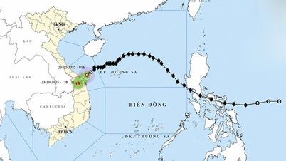
According to the forecast of the National Center for Hydro-Meteorological Forecasting, on the afternoon of October 22, the storm moved into the sea area of Hue - Quang Ngai city, the intensity continued to weaken to level 8; on the night of October 22 and the morning of October 23, the storm weakened into a tropical depression, moving inland to the provinces and cities of Hue - Quang Ngai, on the morning and afternoon of October 23, the storm moved to the Southern Laos area, weakening into a low pressure area.
Due to the impact of cold air, the intensity of storm No. 12 is not too strong (maximum level 10), it cannot increase in intensity like storms No. 10 (BUALOI), No. 11 (MATMO). When storm No. 12 enters the Hoang Sa special zone, it is blocked by a cold air mass, so it changes direction and moves slowly.
Although the storm's intensity is not too high, it is still forecast to cause heavy rain on land because the storm's circulation brings a large amount of moisture from the East Sea to the mainland, combined with strong northeast winds in the East Sea and the Gulf of Tonkin and east wind disturbances. The convergence of wind and moisture from the three systems mentioned above is even stronger due to the wind-blocking effect of the Truong Son range in the Central region, causing the rain to intensify and last for many days, even after the storm dissipates.
Specifically, how will the rain develop, sir?
Rain due to the impact of storm circulation can be divided into 2 phases. Phase 1, from the night of October 22 - 24: Due to the combined influence of storm circulation No. 12 (cold air, East wind), the area from Quang Tri - Da Nang has rainfall from 400-600mm, locally heavy rain over 800mm, heavy rain over 200mm/3 hours.
In Ha Tinh and Quang Ngai areas, rainfall ranges from 100-250mm, locally over 400mm.
During this rainy season, it is necessary to pay attention to the risk of flooding in urban and industrial areas due to heavy rain and rising sea levels, causing slow drainage.
In the second phase from October 25 to 27, due to the influence of cold air combined with the East wind, Quang Tri and Hue city had rainfall from 200-300mm, locally over 500mm.
Ha Tinh province, Da Nang city, Quang Ngai city have rain from 100-200mm. Locally over 300mm. After October 27, rain is likely to continue in the Central region.
How do you assess the flood situation?
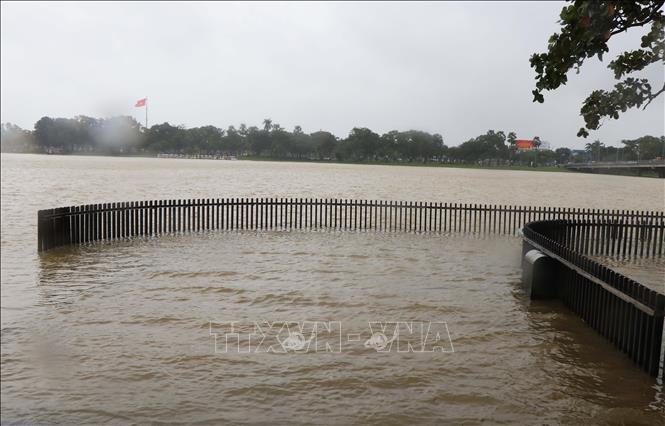
Currently, flood levels on Bo River and Huong River (Hue City) are fluctuating above alert level 1. Other rivers from Quang Tri to Quang Ngai are fluctuating.
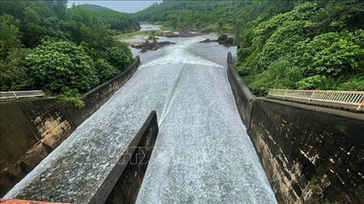
Water levels of large reservoirs on Bo River and Huong River (Hue City) are 4.8 - 16.2m lower than normal water levels, reservoir capacity is 32 - 81% of design capacity; water levels of large reservoirs on Vu Gia Thu Bon River (Da Nang) are 6.5 - 10.5m lower than normal water levels, reservoir capacity is 77.4 - 79.4% of design capacity; water levels of reservoirs on Tra Khuc River basin (Quang Ngai) are 7.7 - 12.3m lower than normal water levels, reservoir capacity is 57.3 - 74.5% of design capacity.
According to the National Center for Hydro-Meteorological Forecasting, from the night of October 22 to 28, there is a possibility of a flood on rivers from Quang Tri to Quang Ngai. The flood peak on rivers is likely to be as follows: Quang Tri province, Gianh river, at Mai Hoa station at alert level 2 - alert level 3; Kien Giang river at Le Thuy station above alert level 3 is 1.5; Hieu river, at Dong Ha station from alert level 2 - alert level 3; Ben Hai river, at Hien Luong station from alert level 2 - alert level 3; Thach Han river at Thach Han station at alert level 3.
Hue city, Bo river at Phu Oc station is above alert level 3 from 0.3 - 0.5m; Huong river at Kim Long is above alert level 3 from 0.2 - 0.3m. Da Nang city, Vu Gia river at Ai Nghia station is above alert level 3 from 0.3 - 0.5m; Thu Bon river at Cau Lau station is above alert level 3 from 0.1 - 0.2m; Tam Ky river at Tam Ky station is above alert level 3 from 0.2 - 0.4m.
Quang Ngai province, Tra Bong river at Chau O station, Tra Cau at Tra Cau station above alert 3 from 0.3 - 0.5m; Tra Khuc river at Tra Khuc station below alert 3 from 0.2 - 0.3m; Ve river at Ve river station above alert 3 is 0.5m; Se San river at Kon Tum station from alert 1 - alert 2.
There is a risk of widespread flooding from Quang Tri to Quang Ngai and a high risk of flash floods on rivers and streams and landslides on steep slopes in mountainous areas from Quang Tri to Quang Ngai provinces.
Can you give details of areas at risk of being affected by strong winds, flash floods and inundation?
In Quang Tri province, there are 16 communes and wards at risk of being affected by strong winds, including: Hoa Trach, Nam Gianh, Nam Ba Don, Quang Trach, Tan Gianh, Bac Trach, Nam Trach, Hoan Lao, Nam Trach, Dong Thuan, Quang Ninh, Ninh Chau, Truong Ninh, Le Thuy, Cam Hong, Sen Ngu, Tan My, Dong Hoi, Cua Viet, Cua Tung, and My Thuy.
Risk of flash floods and landslides in communes and wards including: Bac Trach, Dan Hoa, Dong Le, Hoa Trach, Kim Dien, Kim Phu, Minh Hoa, Nam Ba Don, Phu Trach, Quang Trach, Tan Gianh, Tan Thanh, Thuong Trach, Trung Thuan, Tuyen Binh, Tuyen Hoa, Tuyen Phu, Tuyen Son; A Doi, Bo Trach, Dong Trach, Hoan Lao, Nam Gianh, Phong Nha, Tuyen Lam; Huong Lap, Huong Phung, Khe Sanh, Kim Ngan, La Lay, Lao Bao, Le Ninh, Lia, Dong Son, Quang Ninh, Ta Rut, Tan Lap, Truong Ninh, Truong Phu, Truong Son.
Risk of serious flooding in communes/wards including: Ai Tu, Ba Long, Ba Don, Bac Trach, Ben Hai, Bac Gianh, Cam Hong, Cam Lo, Cua Viet, Dong Hoi, Dong Le, Dong Son, Dong Thuan, Dong Ha, Gio Linh, Hai Lang, Hieu Giang, Kim Ngan, Le Ninh, Le Thuy, My Thuy, Nam Ba Don, Nam Gianh, Nam Dong Ha, Ninh Chau, Quang Ninh, Quang Trach, Sen Ngu, Tan Gianh, Tan My, Trieu Binh, Trieu Co, Trieu Phong, Truong Ninh, Truong Phu, Trung Thuan, Tuyen Binh, Tuyen Hoa, Tuyen Phu, Vinh Dinh.
For Hue city, there is a risk of strong storms in 15 communes/wards: Phong Dinh, Phong Phu, Dan Dien, Phong Quang, Quang Dien, Thuan An, Hoa Chau, Duong No, My Thuong, Phu Ho, Phu Vang, Phu Vinh, Vinh Loc, Phu Loc, Chan May- Lang Co
High risk of flash floods and landslides in the following communes/wards: A Luoi, Phong Dien, Long Quang, Khe Tre, Nam Dong, Chan May - Lang Co, Binh Dien, Huong Thuy, Loc An, Phu Loc...
Risk of serious flooding in the following communes/wards: Phong Dinh, Phong Phu, Phong Quang, Phong Thai, Dan Dien, Quang Dien, Hoa Chau, Duong No, Thuan An, Huong Tra, Huong An, Kim Tra, My Thuong, Phu Ho, Kim Long, Thuan Hoa, Phu Xuan, Thuy Xuan, Huong Thuy, Vy Da, An Cuu, Thanh Thuy, Phu Vinh, Phu Vang, Vinh Loc, Phu Bai, Loc An, Hung Loc, National Highway 1 through the communes of Phu Loc, Loc An, Hung Loc has many deep flooding points and stretches for several hundred meters (due to rain pouring from Bach Ma range flowing over the road).
Along with that, in Da Nang city, communes and wards at risk of being affected by strong winds include: Hai Chau, Hoa Cuong, Thanh Khe, Son Tra, An Hai, Hoa Khanh, Lien Chieu, Ngu Hanh Son, Quang Phu, Ban Thach, Thang Binh, Thang An, Thang Truong, Thang Dien, Thang Phu, Dong Duong, Hoi An, Hoi An Dong, Hoi An Tay, Tan Hiep, Tam Ky, Huong Tra.
Risk of flash floods and landslides in the following communes and wards: Hai Van, Ben Giang, Kham Duc, Phuoc Nang, Phuoc Chanh, Phuoc Hiep, Phuoc Thanh, Thu Bon, Duy Xuyen, Que Son Trung, Que Phuoc, Nong Son, Hiep Duc, Viet An, Son Cam Ha, Lanh Ngoc, Dong Duong, Tay Ho, Tien Phuoc, Thanh Binh, Tra My, Tra Lien, Phu Ninh, Duc Phu, Nui Thanh, Tam My, Tra Giap, Nam Tra My, Tra My, Tra Tap, Tra Leng.
Risk of serious flooding in the following communes/wards: Nam Phuoc, Xuan Phu, Duy Nghia, Thang An, Dien Ban, Hoi An Tay, Hoi An Dong, An Thang, Dien Ban Tay, Dien Ban Bac, Hoa Tien, Dai Loc, Vu Gia, Thu Bon; Ngu Hanh Son, Cam Le, Hoa Cuong, Hoa Tien, Nong Son, Que Phuoc, Dong Giang, Chien Dan, Quang Phu, Tam Xuan, Huong Tra, Tam Ky, Ban Thach.
In addition, in Quang Ngai province, the following wards/communes are at risk of being affected by strong winds: Van Tuong, Dong Son, Binh Son, Tinh Khe, An Phu.
Risk of flash floods and landslides in the communes: Ba To, Ba Vi, Ba To, Ba Dinh, Ba Vinh, Ba Dong, Ba Xa, Dang Thuy Tram, Minh Long, Son Mai, Tra Bong, Dong Tra Bong, Tay Tra, Thanh Bong, Ca Dam, Tay Tra Bong, Son Ha, Son Linh, Son Ha, Son Thuy, Son Ky, Son Tay, Son Tay Thuong, Son Tay Ha, Kon Plong, Mang But, Ngoc Linh, Xop, Dak Man, Dak Blo, Mang Ri.
Flood risk includes communes and wards: Thien Tin, Nghia Hanh, Ve Giang, Long Phung, Dinh Cuong, Duc Pho Ward, Tra Cau, Binh Son Commune, Binh Minh, Binh Chuong, Binh Duong Commune, Nghia Giang, Truong Giang, Tinh Khe, Mo Cay Commune, Long Phung, Mo Duc, Dinh Cuong, Nghia Hanh, Son Linh, Son Ha, Truong Son, Son Tay Ha, Tu Nghia, Nghia Giang, Ve Giang, Tra Giang, Cam Thanh, Nghia Lo, Truong Quang Trong, An Phu, Dong Son, Tinh Khe, Nghia Phu, An Tay.
Sincerely thank Dr. Mai Van Khiem!
Source: https://baotintuc.vn/van-de-quan-tam/tien-si-mai-van-khiem-bao-so-12-suy-yeu-nhung-nguy-co-ngap-lut-sat-lo-dat-o-trung-bo-rat-cao-20251022121635121.htm
![[Photo] Da Nang: Shock forces protect people's lives and property from natural disasters](https://vphoto.vietnam.vn/thumb/1200x675/vietnam/resource/IMAGE/2025/10/22/1761145662726_ndo_tr_z7144555003331-7912dd3d47479764c3df11043a705f22-3095-jpg.webp)
![[Photo] General Secretary To Lam and his wife begin their official visit to Bulgaria](https://vphoto.vietnam.vn/thumb/1200x675/vietnam/resource/IMAGE/2025/10/23/1761174468226_tbtpn5-jpg.webp)
![[Photo] Comrade Nguyen Duy Ngoc visited and worked at SITRA Innovation Fund and ICEYE Space Technology Company](https://vphoto.vietnam.vn/thumb/1200x675/vietnam/resource/IMAGE/2025/10/23/1761174470916_dcngoc1-jpg.webp)
![[Photo] Award Ceremony of the Political Contest on Protecting the Party's Ideological Foundation](https://vphoto.vietnam.vn/thumb/1200x675/vietnam/resource/IMAGE/2025/10/22/1761151665557_giaia-jpg.webp)
![[Photo] Prime Minister Pham Minh Chinh chairs meeting on nuclear power plant construction](https://vphoto.vietnam.vn/thumb/1200x675/vietnam/resource/IMAGE/2025/10/22/1761137852450_dsc-9299-jpg.webp)


Comment (0)