
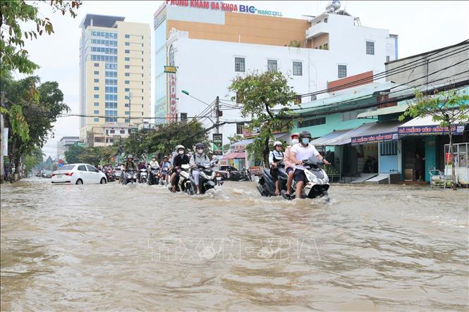
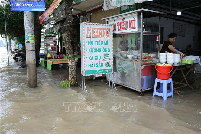
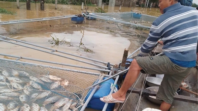
The historic high tide has caused severe flooding in the inner city of Can Tho, severely affecting traffic, daily life and business activities of the people. Many roads and areas that were never flooded or were only slightly flooded before are now submerged in water.
In Binh Thuy district, "traditional" flooded roads such as Cach Mang Thang Tam and Bui Huu Nghia recorded the deepest flooding ever, with some places having water rising above the waist. In Ninh Kieu ward, water from Can Tho river still overflowed Ben Ninh Kieu, flooding central roads such as Hoa Binh , Nam Ky Khoi Nghia, and Ngo Quyen. In Cai Rang ward, Vo Nguyen Giap street was deeply flooded, even Nam Long residential area, which is higher than other areas and has not been flooded before, was also attacked by the tide this morning.
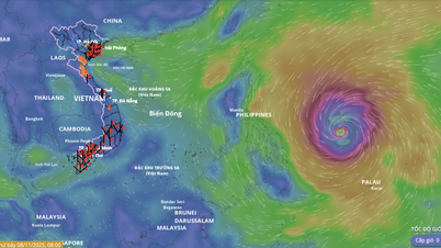
Speaking to a reporter from the Vietnam News Agency on November 6, Mr. Pham Duc Doan, Director of the Can Tho City Hydrometeorological Station, said that this was an unusual development, and preliminary assessment was due to the influence of a distant storm circulation. The peak tide is forecast to remain at a very high level and may continue to increase slightly in the next 1-2 days.
According to the Emergency Flood Bulletin issued at 9:00 a.m. on November 6 by the Can Tho City Hydrometeorological Station, the highest peak tide level measured at 7:00 a.m. at Can Tho station was 2.35 m, 35 cm higher than the III alarm level. Other stations were also at very high levels, such as Dai Ngai at 2.16 m (16 cm above the III alarm level), Tran De at 2.44 m (14 cm above the III alarm level), and Phung Hiep at 1.90 m (50 cm above the III alarm level).
The meteorological agency has warned of a level 2 risk of natural disasters due to high tides. The risk of deep flooding and landslides in low-lying areas, along rivers and outside the dykes is very high, seriously affecting production, traffic and daily life. The flooding time in Can Tho is expected to last for a long time, concentrated from 1:30 to 7:30 am and from 2:30 to 9:00 pm.
Analyzing this development, Mr. Pham Duc Doan, Director of Can Tho Hydrometeorological Station, emphasized the unusual factor of the high tide. In the historic high tide at the end of October 2025, all the factors converged: strong high tide, high flood in the upper reaches of Tien and Hau rivers and strong northeast monsoon pushing water in. However, in this high tide, the flood level in the upper reaches was lower than the previous one. According to Mr. Doan, the main cause could come from the influence of a storm operating far away, near the Truong Sa archipelago.
Although the storm was very far away and did not directly affect it, the storm's outer circulation interacted with the Northeast wind zone (which was weaker this time due to being sucked in by the storm). This interaction, according to preliminary assessments, pushed the water level in the Mekong Delta's river mouths to unusually high levels.
The leader of the Can Tho Hydrometeorological Station also said that this is only an initial assessment, not an official scientific study and that it is necessary to monitor a few more storms to be able to draw an accurate conclusion.
Regarding the forecast, Mr. Pham Duc Doan said that the peak tide on the afternoon of November 6 will be approximately the same as the peak in the morning (about 2.35 m). On November 7, the peak tide may be approximately the same or 1-2 cm higher. This very high water level will change little until November 8-9, then begin to fall rapidly in Can Tho from November 10.
However, the Director of the Can Tho Hydrometeorological Station also noted that while the water level in Can Tho began to drop rapidly from November 10, the inland areas such as Nga Bay, Vi Thanh (Hau Giang) and areas in Soc Trang will be more severely affected. Mr. Doan said that the water level in these areas will remain at a very high level and drop very slowly, causing the deep flooding to possibly last until mid-November.
In general, Mr. Doan said that this high tide will be the highest peak of 2025. From now until the end of the year, there will be 2-3 more high tides, but the peak tide will be lower and the flooding time will be shorter, reducing the level of danger.
Source: https://baotintuc.vn/xa-hoi/trieu-cuong-o-can-tho-lap-dinh-moi-20251106112619324.htm


![[Photo] Heavy damage after storm No. 13 in Song Cau ward, Dak Lak province](https://vphoto.vietnam.vn/thumb/1200x675/vietnam/resource/IMAGE/2025/11/08/1762574759594_img-0541-7441-jpg.webp)


![[Video] Hue Monuments reopen to welcome visitors](https://vphoto.vietnam.vn/thumb/402x226/vietnam/resource/IMAGE/2025/11/05/1762301089171_dung01-05-43-09still013-jpg.webp)


Comment (0)