
Project Overview
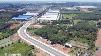
Component project 2-4: Construction of the expressway section from Thay Cai canal to Ho Chi Minh City - Trung Luong expressway, part of Ho Chi Minh City Ring Road 4, with a length of about 42.55 km, with a total investment of nearly 20,500 billion VND. The starting point is located at Thay Cai canal, the border of Tay Ninh province and Ho Chi Minh City; the end point is at the intersection of Ring Road 4 with Ho Chi Minh City - Trung Luong expressway in Ben Luc commune, Tay Ninh province. The scope of implementation goes through 7 communes of Tay Ninh province, including Hau Nghia, Duc Lap, Hoa Khanh, Duc Hue, Thanh Loi, Binh Duc and Ben Luc.
Technical planning and design
The scale of the road section is invested in phases with 4 expressway lanes, design speed of 100 km/h, roadbed width of 25.5 m according to National Technical Regulations on expressways. The project type belongs to the group of important national projects, invested in the form of public-private partnership.
For the section without side roads, the project will arrange two bridge units with each unit being 12.25 m wide, total bridge width 25 m. For the section with side roads, it will arrange two bridge units with each unit being 19.75 m wide, total bridge width 40 m. The project will construct 36 cross-road drainage culverts along the route, toll station system, and intelligent traffic management ITS system suitable for the scale of the route.

Infrastructure and connectivity
The route has the function of connecting expressways and radial national highways that have been and are being built to promote efficiency, contributing to reducing traffic congestion in inner-city areas, creating conditions for the development of inter-regional transport services.
The project will build 18 bridges, including 10 overpasses across rivers/canals and viaducts, and 8 direct overpasses. Three interconnecting interchanges include the interchange with National Highway N2 - Provincial Road 825 - Ho Chi Minh Road, Chon Thanh - Duc Hoa section (Km9+374) designed in a diamond shape; the interchange with National Highway N2 (Km25+335) in a double Trumpet shape; the interchange with Ho Chi Minh City - Trung Luong Expressway (Km42+540) in an additional double Trumpet shape.

Impact and site clearance
The total land use demand of the project is 579.5 hectares, mainly land for annual crops - crops (383 hectares), aquaculture land (104.4 hectares), residential land (79.05 hectares) and traffic land (12.85 hectares). The number of affected households is 2,290 households.
Implementation progress
The investment project is expected to be approved in December. The progress of compensation, site clearance, relocation of underground technical infrastructure, resettlement and relocation will be from the first quarter of 2026 to the third quarter of 2026. Construction will be from the second quarter of 2026 to the second quarter of 2028, with the construction period for the road section being 24 months and the bridge being 24 months.
Legal and Risk Considerations
The Prime Minister has approved the detailed planning of the Ho Chi Minh City Ring Road 4 project with a total length of about 199 km, but so far only about 10 km of the section through the former Binh Duong province (now Ho Chi Minh City) has been built. People and investors need to closely monitor the approval progress, update official information from the authorities and verify the legality before any decisions related to land and real estate in the project area.
Source: https://baolamdong.vn/vanh-dai-4-qua-tay-ninh-425-km-20500-ty-dong-khoi-cong-quy-ii2026-404879.html


![[Photo] Prime Minister Pham Minh Chinh chairs the 15th meeting of the Central Emulation and Reward Council](/_next/image?url=https%3A%2F%2Fvphoto.vietnam.vn%2Fthumb%2F1200x675%2Fvietnam%2Fresource%2FIMAGE%2F2025%2F11%2F27%2F1764245150205_dsc-1922-jpg.webp&w=3840&q=75)


![[Photo] President Luong Cuong attends the 50th Anniversary of Laos National Day](/_next/image?url=https%3A%2F%2Fvphoto.vietnam.vn%2Fthumb%2F1200x675%2Fvietnam%2Fresource%2FIMAGE%2F2025%2F11%2F27%2F1764225638930_ndo_br_1-jpg.webp&w=3840&q=75)


Comment (0)