

According to information from the Earthquake Information and Tsunami Warning Center - Institute of Geophysics, at 7:39 PM on December 5th, a 3.0 magnitude earthquake with a focal depth of approximately 16km occurred in Thuan Chau district, Son La province.
The Earthquake Information and Tsunami Warning Center - Institute of Geophysics is continuing to monitor this earthquake.
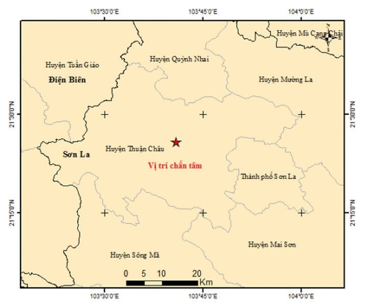
Map of earthquake epicenters.
Previously, on June 15th, a 3.7 magnitude earthquake occurred in the border area of Son La. Specifically, at 8:30 PM on June 15th, an earthquake with a magnitude of 3.7 occurred at coordinates (20.652 degrees North latitude, 104.357 degrees East longitude), with a focal depth of approximately 16km.
The Northwest region is home to many active fault lines, such as the Dien Bien - Muong Lay fault, which extends for about 200km, and the Song Ma - Tuan Giao - Lai Chau fault.
This area has recorded many earthquakes. Several strong earthquakes have occurred here, such as the 6.9 magnitude earthquake in the Dien Bien basin in 1935, the 6.7 magnitude earthquake in Tuan Giao town in 1983, and the 5.3 magnitude earthquake in Dien Bien Phu city in 2001.
Vien Minh
Source


![[Photo] The rapeseed flower season heralds the arrival of spring on the summit of Suoi Giang.](https://vphoto.vietnam.vn/thumb/402x226/vietnam/resource/IMAGE/2026/02/12/1770911320984_baolaocai-br_chuyen-muc00-00-38-10still068-jpg.webp)


Comment (0)