
There is a 360 degree West Lake
Coming to the capital Hanoi , besides walking around the mossy Old Quarter and the hundred-year-old pace of life in the city, visitors can hardly miss West Lake, a land of beautiful mountains and rivers in the heart of the city.
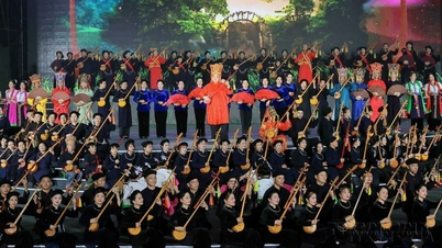
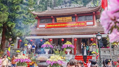
Hidden in that vast space of wind and water are layers of ancient cultural sediments, traditional Vietnamese imprints that have been preserved intact over time. Here, visitors can visit the ancient Tran Quoc Pagoda reflecting on the lake surface, the sacred Tay Ho Palace, or ancient craft villages such as Nhat Tan peach village, Phu Thuong sticky rice village,... places that have existed for hundreds, even thousands of years, contributing to the cultural depth of the land of Tay Ho.
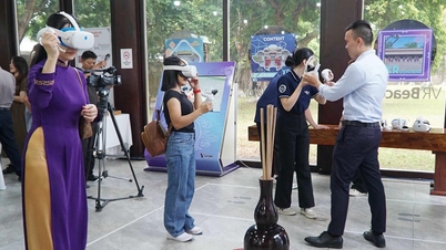
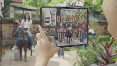
To help tourists have a comprehensive view and choose their desired destinations, Tay Ho ward has applied digital technology to create "heritage maps". Specifically, since 2023, Tay Ho ward (formerly Tay Ho district) has implemented the Project "Building a basic database system (digital) to serve the work of cultural preservation, relic management and tourism development in Tay Ho district", to promote the application of science and technology in the management and development of cultural industries in the area, while providing the fastest information to people and tourists about the culture and tourism of Tay Ho district.
“Tay Ho 360” is not only a simple information page, but is also considered an important step forward in the application and development of information technology and artificial intelligence, to fully meet the needs of tourism and cultural information of both local people and tourists. Some of the outstanding applications of this product are digitizing historical and cultural relics, applying advanced virtual reality and augmented reality VR360 technology, this website helps digitize historical relics, festivals and commercial, service and tourism destinations, bringing unique experiences to users.

For example, a first-time visitor to West Lake can open the digital heritage map and choose the “spiritual journey”, which takes them through Tran Quoc Pagoda, Tay Ho Palace, Kim Lien Temple with brief explanations about history and architecture. If they love the heritage of craft villages, they can choose the “lakeside village” route to explore Nhat Tan peach growing, Quang Ba kumquat growing or the ancient Nghi Tam village. Choosing such a journey not only helps visitors be more proactive but also creates a sense of deeper exploration, a personal connection with the land they are experiencing.
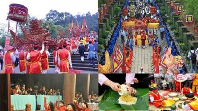
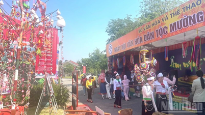
Another strength of the digital heritage map is the ability to link tourism information, services, and festivals in real time. When visitors select a destination on the map, the system can suggest additional opening hours, upcoming events, surrounding culinary spaces, or typical tourism products. This helps improve the quality of the trip and prolong the length of stay of visitors. With West Lake, where there are many festivals such as the Tay Ho Palace Festival, the Mother Goddess Procession, or street events along the lake, updating information online also helps control the number of visitors and reduce overload at spiritual sites during peak hours.
In particular, the digital heritage map also helps to enhance the West Lake brand in the digital environment, the field that determines the competitiveness of tourist destinations. When each heritage has a “digital profile” including images, videos, stories, location maps and experience suggestions, West Lake will become an “open cultural library” for international tourists to easily access. This is in line with the smart tourism development strategy that Hanoi is implementing, which emphasizes the role of digital transformation to increase competitiveness and attract international visitors.
Promoting the potential of West Lake
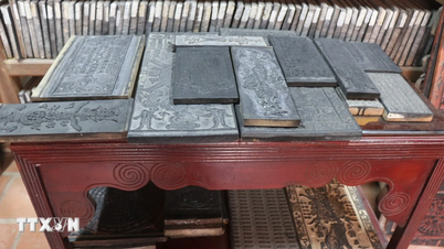
Tay Ho Ward with a large natural area, of which West Lake occupies more than 526 hectares, is considered the "green lung" of the Capital, converging dozens of relics ranked at all levels, notably Tran Quoc Pagoda, Tay Ho Palace, Yen Phu Communal House, Quan Thanh Temple and many ancient villages and intangible heritages associated with the history of Thang Long land. This makes the process of inventorying, assessing the status of relics, monitoring restoration activities or handling violations difficult. A digital heritage map will help gather all this information on a single platform: location of relics, history of formation, documentary photos, technical drawings, archaeological data, current status and level of conservation.
In fact, many localities in the country have deployed heritage management models using digital technology and recorded clear effectiveness. For example, Hue's heritage management system allows for real-time information lookup of relics, supporting functional forces in early detection of degradation risks. These results show that the digitization of heritage is not only a trend but has become a strategic requirement. When applied to Tay Ho, where there is a high density of relics and rapid urban changes, digital heritage maps will play an important role in monitoring the current status of each site, providing visual data for planning and conservation decisions.

Another great benefit of digital heritage maps is the ability to connect management agencies and the community. People living around the West Lake area, especially in residential areas with relics, can promptly report signs of degradation, unusual changes or repair needs through a digital platform. This not only reduces the burden on specialized units but also helps increase the community's responsibility for the living heritage around them. Similar experiences have been recorded in many Asian cities, where the application of digital heritage helps mobilize volunteers and local people to monitor and update information regularly. With West Lake, this model is completely feasible because the lakeside community is closely connected to local cultural and religious activities.
As in a scientific seminar assessing the potential of West Lake, Dr. Le Thi Thu Huong (Hanoi Capital University) said that in order to develop and build West Lake into a focal point in planning, it is necessary to understand the history and culture of this area, starting from the root, restoring, preserving and reconstructing historical and cultural relics along West Lake and surrounding areas; developing traditional festivals; traditional craft villages; building cultural spaces...
To do this, it is necessary to have a strategy and synchronous solutions, mobilize resources and the participation of all levels, sectors and especially the local people in the suburbs, the people of Tay Ho district - the direct owners of the tangible and intangible cultural heritages in the historical and cultural space of West Lake.
In the coming time, to realize the goal of building Tay Ho ward into a cultural, service and tourism center of stature, shaping the West Lake area as a new development driving force of the Capital, focus on implementing key groups of tasks and solutions.
The application of “digital heritage maps” not only supports the management of the current status, but also helps the authorities to be more proactive in planning work. Thanks to the synchronized data system, experts can assess the level of interaction between heritage and the living environment, traffic, and tourism economy to come up with appropriate solutions. For example, clearly defining the protection radius of the relics of Tran Quoc Pagoda and Tay Ho Palace will help the city limit the construction of large-scale projects that affect the cultural landscape. From there, the digital heritage map is not only a management tool but also a foundation for planning a long-term conservation strategy.
Source: https://baophapluat.vn/ban-do-di-san-thong-minh-giu-hon-tay-ho-trong-thoi-dai-so.html


Comment (0)