
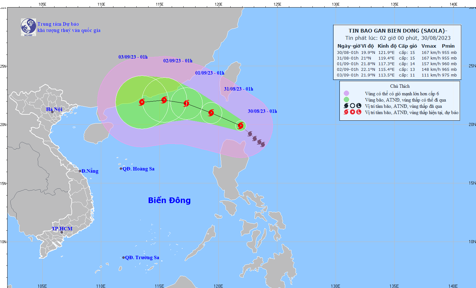
According to the National Center for Hydro-Meteorological Forecasting, at 1:00 a.m. on August 30, the center of storm SAOLA was located at about 19.9 degrees North latitude; 121.9 degrees East longitude, in the sea north of Luzon Island (Philippines). The strongest wind near the center of the storm was level 15 (167-183 km/h), gusting to level 17, moving northwest at a speed of 10-15 km/h.
Forecast until 1:00 a.m. on August 31, the storm will move in the Northwest direction, storm intensity level 15, gust level 17, moving 10 - 15 km per hour.
From the next 72 to 120 hours, the storm will move mainly in a westerly direction, about 10km per hour, and its intensity will likely weaken.
Due to the impact of the storm, the northeastern sea area of the North East Sea has strong winds of level 6, from the afternoon and night of August 30, it will strengthen to level 7-8, near the storm center it will be strong at level 10-12, then increase to level 13-15, gusting above level 17; the sea will be very rough.
In the eastern sea of the North East Sea, waves are 3.0-5.0m high./.
Source


![[Photo] Collecting waste, sowing green seeds](https://vphoto.vietnam.vn/thumb/1200x675/vietnam/resource/IMAGE/2025/10/18/1760786475497_ndo_br_1-jpg.webp)
![[Photo] General Secretary To Lam attends the 95th Anniversary of the Party Central Office's Traditional Day](https://vphoto.vietnam.vn/thumb/1200x675/vietnam/resource/IMAGE/2025/10/18/1760784671836_a1-bnd-4476-1940-jpg.webp)
![[Photo] Closing ceremony of the 18th Congress of Hanoi Party Committee](https://vphoto.vietnam.vn/thumb/1200x675/vietnam/resource/IMAGE/2025/10/17/1760704850107_ndo_br_1-jpg.webp)


Comment (0)