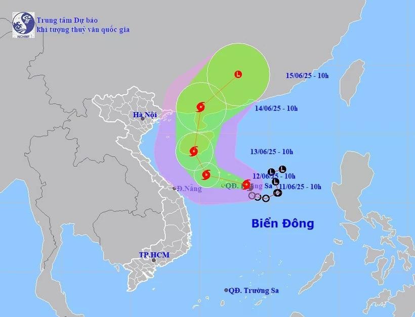
Location and path of storm No. 1. (Source: National Center for Hydro-Meteorological Forecasting)
According to the latest update from the National Center for Hydro-Meteorological Forecasting, at 10:00 a.m. on June 11, the center of the storm was located at about 16.3 degrees North latitude; 113.4 degrees East longitude in the sea east of Hoang Sa archipelago.
The strongest wind near the storm center is level 8 (62-74 km/h), gusting to level 10. The storm moves in a West Northwest direction at a speed of about 10 km/h.
Commenting specifically on the storm's developments, Dr. Hoang Phuc Lam, Deputy Director of the National Center for Hydro-Meteorological Forecasting, said that as of 10:00 a.m. on June 12, the storm was moving in a West-Northwest direction over the area west of Hoang Sa at a speed of about 10-15 km/h and was likely to strengthen. The storm's strongest wind was level 9, gusting to level 11.
The dangerous area is identified as the western part of the North East Sea (including Hoang Sa area), the offshore area from Quang Tri - Quang Ngai . Natural disaster risk level 3.
At 10:00 a.m. on June 13, the storm was moving northwestward over the southern part of Hainan Island (China) at a speed of about 10 km/h. The storm's strongest wind was level 10, gusting to level 13.
The dangerous area is identified as the West of the North East Sea (including the West of the Hoang Sa area), the offshore area from Quang Tri - Quang Ngai, the East sea area of the Gulf of Tonkin. Natural disaster risk level 3.
At 10:00 a.m. on June 14, the storm moved northeastward over mainland China at a speed of about 15 km/h and gradually weakened. The storm's strongest winds were level 8, gusting to level 10.
The dangerous area is identified as the sea area west of the North East Sea and the sea area east of the Gulf of Tonkin.
Warning, in the next 72-96 hours, the storm will move northeast at about 20km per hour, continuing to weaken.
Due to the influence of the storm, the western part of the North East Sea (including the Hoang Sa sea area), the northern part of the central East Sea has thunderstorms and strong winds of level 6-7, the area near the storm's center has winds of level 8-9, gusts of level 11, waves 3-5m high, very rough seas.
The sea off the coast of Quang Tri-Quang Ngai from the night of June 11 has gradually increased winds to level 6-7, near the storm center level 8, gusting to level 10, waves 2-4m high, rough seas.
Ships operating in the above mentioned dangerous areas are likely to be affected by storms, whirlwinds, strong winds and large waves.
Due to the influence of storm No. 1, from the afternoon of June 11 to June 13, in the Central Central region, there will be heavy to very heavy rain with common rainfall from 100-300mm, some places over 450mm; the Northern Central Highlands region will have moderate rain, heavy rain and thunderstorms, locally very heavy rain with common rainfall from 70-150mm, some places over 200mm.
On the morning of June 11, the tropical depression in the eastern area of Hoang Sa archipelago strengthened into a storm - storm number 1 in 2025, internationally named WUTIP.
Source: https://baolaocai.vn/bao-so-1-di-chuyen-theo-huong-tay-tay-bac-co-kha-nang-manh-them-post403157.html

























Comment (0)