
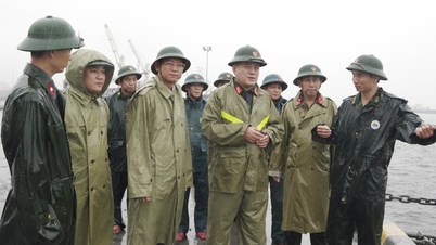
Deputy Minister Nguyen Hoang Hiep (in blue shirt standing in the middle) and leaders of Gia Lai province inspected ships at Quy Nhon port on the afternoon of November 5 - Photo: Tuan Anh.
According to the National Center for Hydro-Meteorological Forecasting, at 4:00 a.m. on November 6, the center of storm No. 13 (storm KALMAEGI) was located at about 13.3 degrees North latitude; 113.3 degrees East longitude, about 450 km East Southeast of Quy Nhon (Binh Dinh province). The strongest wind near the center of the storm is level 14, gusting to level 17. In the next 12 hours, the storm will move in the West Northwest direction, at a speed of 25-30 km/h, with sustained winds of level 14, gusting to level 17.
Proactively ensure safety of ships and reservoirs
According to the Border Guard Command, as of 6:30 a.m. on November 6, 61,475 vehicles/291,384 workers had been notified, counted and instructed about the location and direction of the storm; currently, no vehicles are operating in the danger zone. Localities that have issued sea bans include: Da Nang , Quang Ngai, Khanh Hoa, Gia Lai, Dak Lak and Lam Dong.
Regarding reservoirs, according to the updated report at 5:00 a.m. the same day, the water level at many large lakes in the Central and Central Highlands regions is high, many lakes have had to discharge to ensure safety. Some lakes have large discharge flows such as Huong Dien (Hue) 1,140 m³/s, Song Tranh 2 ( Quang Nam ) 1,481 m³/s, Ialy (Gia Lai) 939 m³/s, Song Ba Ha (Dak Lak) 440 m³/s.
From the evening of November 5 to the morning of November 6, the Central and Southern regions had moderate rain, heavy rain, and locally very heavy rain, with rainfall generally below 30mm; some places had higher rainfall such as: Xuan Forestry Farm (Can Tho) 126mm, Hiep Hung (Can Tho) 69mm, Dien Huong (Hue) 45mm.
It is forecasted that on November 6-7, from Da Nang to Dak Lak, there is a possibility of very heavy rain of 200-400mm, in some places over 600mm/period; from the area of South Quang Tri to Hue, Khanh Hoa and Lam Dong, there will be rain of 150-300mm, in some places over 450mm/period. From November 7-8, the rain will spread to Thanh Hoa to North Quang Tri, with common rainfall of 50-100mm, in some places over 200mm/period.
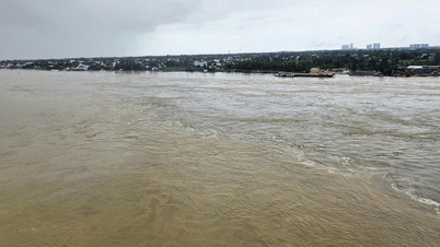
Floods on rivers in the Central region are slowly receding. The water level at 6:00 a.m. on November 6 at Le Thuy station (Kien Giang river, Quang Tri) was 2.29 m, 0.09 m above alert level 2; Phu Oc station (Bo river, Hue) was 3.65 m, 0.65 m above alert level 2; Vu Gia river (Da Nang) at Ai Nghia was 7.8 m, 0.2 m below alert level 2. It is forecasted that from November 6-9, many rivers from Quang Tri to Lam Dong are likely to experience a new flood, with the flood peak reaching alert levels 2-3, and in some places exceeding alert level 3.
Emergency response deployment
On November 6, Deputy Prime Minister Tran Hong Ha directly chaired a meeting with ministries, branches and localities from Quang Tri to Khanh Hoa at the Forward Command Center to direct emergency response to storm No. 13.
Previously, the Prime Minister issued Official Dispatch No. 208/CD-TTg (dated November 4) requesting localities from Ha Tinh to Khanh Hoa to proactively develop plans to prevent, avoid, respond, and ensure the safety of dyke systems, reservoirs, coastal and mountainous residential areas.
The National Steering Committee for Civil Defense, the Ministry of Agriculture and Environment, the Ministry of Industry and Trade, the Ministry of Foreign Affairs and relevant ministries and branches have continuously issued urgent dispatches and instructions; at the same time, working delegations of the Ministry of Agriculture and Environment led by Deputy Minister Nguyen Hoang Hiep have inspected the situation in Da Nang, Quang Ngai and Gia Lai.
The Department of Dyke Management and Natural Disaster Prevention and Control organized a 24/7 duty, closely monitoring the developments of storms, floods and rains; coordinated with Zalo Vietnam to send warning messages and boat safety instructions to 6 million people in coastal communes from Ha Tinh to Binh Thuan.
Localities have proactively deployed the work of evacuating people, operating reservoirs, and arranging emergency forces on standby. Gia Lai province has evacuated 2,337 households/7,097 people from dangerous areas; Khanh Hoa and Gia Lai have allowed students to stay home from school on November 6-7 to ensure safety.
On the evening of November 5, Deputy Minister of Agriculture and Environment Nguyen Hoang Hiep and the People's Committee of Gia Lai province held a meeting with departments, branches, sectors and communes and wards on storm prevention work No. 13.
Deputy Minister Nguyen Hoang Hiep informed that storm No. 13 is very strong, moving quickly, increasing in intensity, at present, the wind speed shows no signs of decreasing. The storm's path will be straight towards Quy Nhon. From noon on November 6, heavy rain will begin. It is forecasted that on the evening of November 6, storm No. 13 will make landfall, encountering high tides, so the coastal areas are likely to have a very high water level, up to 7-8 m.
"We require hydropower plants and irrigation reservoirs to discharge water to the maximum level from now until the afternoon of November 6 to ensure the safety of downstream areas during storms and floods. All evacuation activities must be completed before 12 noon on November 6. In particular, from 6 pm on November 6, people are absolutely not allowed to go out on the streets in the Eastern region," Deputy Minister Nguyen Hoang Hiep emphasized.
Also according to Deputy Minister Nguyen Hoang Hiep, in addition to Quy Nhon being directly affected by the storm, in the west of Gia Lai province, the wind can gust to level 9 to level 11. Therefore, this area also needs to immediately deploy timely response solutions.
Do Huong
Source: https://baochinhphu.vn/bao-so-13-giat-cap-17-tien-gan-dat-lien-phai-hoan-thanh-so-tan-dan-truoc-12-gio-ngay-6-11-10225110608595213.htm


![[Photo] Prime Minister Pham Minh Chinh receives the delegation of the Semiconductor Manufacturing International (SEMI)](https://vphoto.vietnam.vn/thumb/1200x675/vietnam/resource/IMAGE/2025/11/06/1762434628831_dsc-0219-jpg.webp)



























Comment (0)