
The National Center for Hydro-Meteorological Forecasting said that early on the morning of November 10, typhoon Fung Wong entered the eastern sea area of the northern East Sea, becoming the 14th typhoon this year. The strongest wind near the storm's center is level 13 (134-149 km/h), gusting to level 16. Moving in the West Northwest direction, at a speed of about 15 km/h.
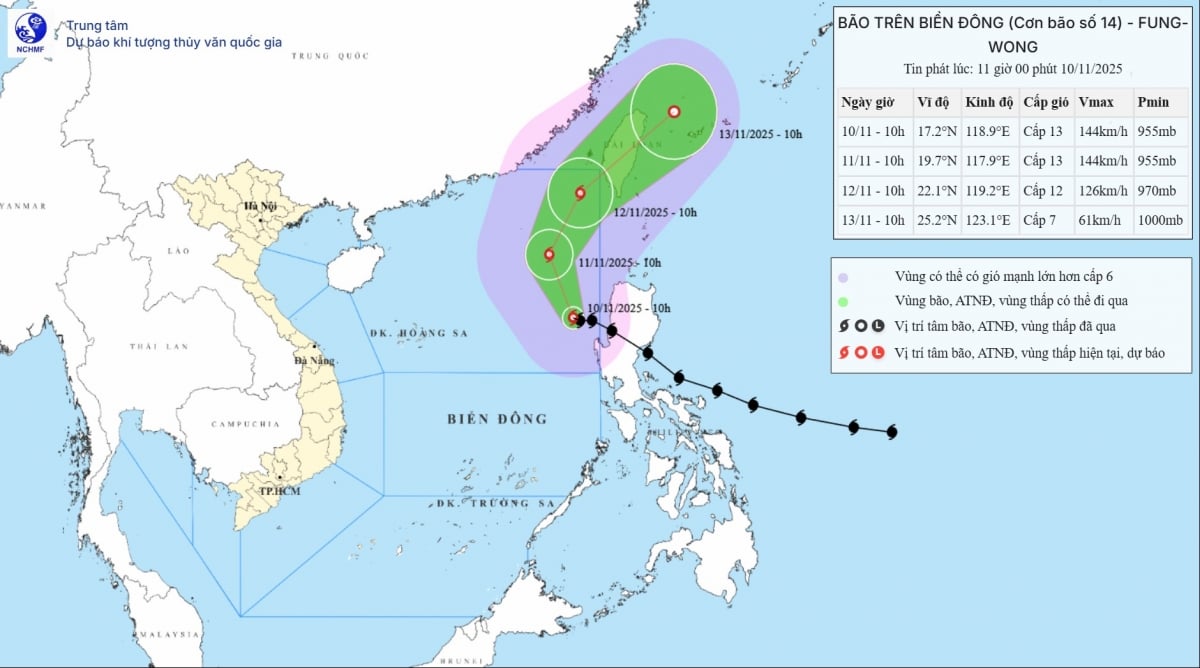
According to the National Center for Hydro-Meteorological Forecasting, at 10:00 a.m. on November 10, the center of the storm was at about 17.2 degrees North latitude; 118.9 degrees East longitude, in the eastern sea area of the North East Sea.
 |
| Movement direction and intensity of storm No. 14 Fung-Wong, updated at 11:00 a.m. on November 10. Source: NCHMF |
The strongest wind near the storm center is level 13 (134-149km/h), gusting to level 16. Moving in the West Northwest direction, speed about 15km/h.
According to the meteorological agency, after entering the East Sea, the subtropical high pressure branch in the north of the storm's guiding stream weakened in intensity and expanded further south of the storm. Therefore, the storm did not move in the usual westerly direction but went north.
As it moves to higher latitudes, the storm will enter the guiding flow of the upper westerly wind zone, so it is likely to change direction to the Northeast and leave the East Sea.
Storm forecast (in the next 24 to 72 hours): Specifically, in the next 24 hours, the storm will begin to change direction from West Northwest to Northwest and slow down, about 10-15km/h.
At 11am tomorrow (November 11), the storm will be at around 19.7N-117.9E; in the eastern sea of the North East Sea; moving in the Northwest direction, 10-15 km/h, maintaining level 13 intensity, gusting to level 16.
In the next 24 hours, the storm changed direction again, moving to the North-Northeast, maintaining its speed. At 11am on November 12, the center of the storm was over the northeastern sea area of the North East Sea, still at level 13 intensity, gusting to level 16.
It is forecasted that in the next 24 hours, the storm will continue to change direction, moving northeast at about 15-20km/h. By November 11, the storm will enter the northeastern coastal area of Taiwan (China) with the intensity reduced to level 8, gusting to level 10.
From the next 72 to 96 hours, the storm will move in the East Northeast direction, traveling 20-25km per hour and continue to weaken.
The eastern sea area of the North East Sea has strong winds of level 8-10; the area near the storm's eye has strong winds of level 11-13, gusts of level 16, waves 5.0-8.0m high, the area near the storm's eye has waves of 8.0-10.0m. The sea is very rough.
All vessels operating in the above mentioned danger zones are susceptible to the effects of storms, whirlwinds, strong winds and large waves.
According to PV/VOV.VN
Source: https://baovinhlong.com.vn/tin-moi/202511/bao-so-14-manh-tren-bien-dong-toc-do-khoang-15kmh-bien-dong-du-doi-69c2628/


![[Photo] Prime Minister Pham Minh Chinh attends the annual Vietnam Business Forum](https://vphoto.vietnam.vn/thumb/1200x675/vietnam/resource/IMAGE/2025/11/10/1762780307172_dsc-1710-jpg.webp)


![Dong Nai OCOP transition: [Article 3] Linking tourism with OCOP product consumption](https://vphoto.vietnam.vn/thumb/402x226/vietnam/resource/IMAGE/2025/11/10/1762739199309_1324-2740-7_n-162543_981.jpeg)


Comment (0)