
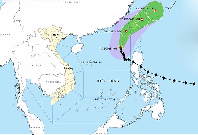
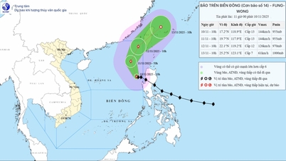
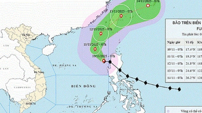
According to the National Center for Hydro-Meteorological Forecasting, at 7:00 a.m. on November 11, the center of the storm was located at about 19.5 degrees North latitude; 118.2 degrees East longitude, in the eastern sea area of the North East Sea. The strongest wind near the center of the storm was level 11 (103-117 km/h), gusting to level 14. Moving in the North-Northwest direction, speed about 10-15 km/h.
Forecast until 7am on November 12, the storm is in the eastern sea of the North East Sea with wind force of level 10, gusting to level 13 and moving in the North Northeast direction, speed of 15 km/h and gradually weakening. The affected area is the northeastern sea of the North East Sea with disaster risk level of level 3.
At 7:00 a.m. on November 13, the storm was in the sea east of Taiwan (China) and gradually weakened into a tropical depression with wind speed of level 6, gusting to level 8 and moving northeast at a speed of about 15 km/h. The affected area is the sea northeast of the North East Sea with a disaster risk level of level 3.
Then, at 7:00 p.m. on November 13, the storm in the sea northeast of Taiwan (China) moved northeast at a speed of 25 km/h and continued to weaken into a low pressure area with winds below level 6.
Due to the impact of the storm, the eastern sea area of the North East Sea has strong winds of level 7-8; the area near the eye of the storm has strong winds of level 9-11, gusts of level 14, waves 4-6m high, the area near the eye of the storm is 7-9m. The sea is very rough.
All vessels operating in the above mentioned danger zones are susceptible to the effects of storms, whirlwinds, strong winds and large waves.
Source: https://baotintuc.vn/van-de-quan-tam/bao-so-14-tiep-tuc-giam-cap-gay-gio-manh-song-lon-tren-khu-vuc-bac-bien-dong-20251111084047759.htm


![Dong Nai OCOP transformation: [Article 4] Reaching national standard products](https://vphoto.vietnam.vn/thumb/402x226/vietnam/resource/IMAGE/2025/11/11/1762825820379_4702-cac-san-pham-trai-cay-chung-nhan-ocop-nongnghiep-174649.jpeg)


![Dong Nai OCOP transition: [Article 3] Linking tourism with OCOP product consumption](https://vphoto.vietnam.vn/thumb/402x226/vietnam/resource/IMAGE/2025/11/10/1762739199309_1324-2740-7_n-162543_981.jpeg)


Comment (0)