
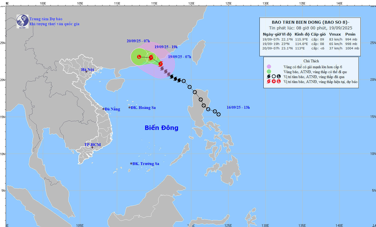
The strongest wind near the storm center is level 9 (75-88km/h), gusting to level 11. Moving northwest at a speed of 10-15km/h.
At 1:00 a.m. on September 20, the storm was on land in the southern part of Guangdong province (China); moving in the West-Northwest direction at a speed of about 10-15 km/h with strong winds of level 6-7, gusting to level 9. The affected area is the northern sea area of the North East Sea. Disaster risk level 3.
At 1 p.m. on September 20, the storm was on the mainland south of Guangdong province (China); moving west at a speed of 15 km/h, entering the mainland and gradually weakening into a low pressure area. Wind force below level 6.
Due to the storm's influence, the northern sea area of the North East Sea has strong winds of level 6-7, gusting to level 9; the area near the storm's eye has strong winds of level 8-9, gusting to level 11, waves 3-5m high, very rough seas.
Vessels operating in the above mentioned dangerous areas are susceptible to the impact of storms, whirlwinds, strong winds and large waves.
On land, according to information from the National Center for Hydro-Meteorological Forecasting, from 2:30 p.m. to 7:30 p.m. on September 19, Phu Tho province will continue to have rain with accumulated rainfall ranging from 20-40mm, in some places over 70m.
Risk warning: flash floods on small rivers and streams, landslides on steep slopes, especially in the communes/wards of Yen Thuy, Yen Tri; An Binh, Dai Dong, Dung Tien, Kim Boi, Lac Luong, Lac Son, Ngoc Son, Nhan Nghia, Yen Phu.
Level of natural disaster risk due to flash floods, landslides, land subsidence due to heavy rain or level 1 flow.
Flash floods and landslides can have very negative impacts on the environment, threaten people's lives; cause local traffic congestion, affect the movement of vehicles; destroy civil and economic works, causing damage to production and socio-economic activities.
The hydrometeorological agency recommends that local authorities pay attention to reviewing bottlenecks and vulnerable locations in the area to have prevention and response measures.
To prevent flash floods and landslides, disaster prevention experts say that provinces and cities need to use engineering and non-engineering solutions.
Regarding engineering measures, provinces and cities need to plant and protect upstream protective forests, especially in areas that often cause flash floods, to protect the ecological environment, protect the vegetation cover, increase the water retention capacity of the basin, and limit the ability to concentrate flood flows. At the same time, build reservoirs to regulate floods in areas where flash floods often occur, clear flood drainage routes, build dikes, flash flood walls, divide flood flows, build additional spillways in reservoirs, etc.
For non-structural measures, localities need to create maps of flash flood risk zones (high risk; medium risk and areas with low risk of flash floods). This map is one of the important bases for localities to propose measures to prevent flash floods; land use planning to limit development in areas with high risk of flash floods.
For previously unplanned residential areas, localities need to re-plan and resettle, moving people out of areas at high risk of flash floods and landslides.
From 10:00 to 13:00, Phu Tho province had moderate to heavy rain such as: Yen Tri 79.4mm, Yen Thuy 50.4mm, Doan Ket 38.4mm,...
Source: https://baotintuc.vn/van-de-quan-tam/bao-so-8-giam-cap-huong-ve-phia-nam-tinh-quang-dong-trung-quoc-20250919153030296.htm


![Dong Nai OCOP transition: [Part 2] Opening new distribution channel](https://vphoto.vietnam.vn/thumb/402x226/vietnam/resource/IMAGE/2025/11/09/1762655780766_4613-anh-1_20240803100041-nongnghiep-154608.jpeg)


Comment (0)