
Storm Tra Mi is constantly changing direction, likely to enter the East Sea tomorrow (October 24). Around noon on October 26, the area near the storm's center will reach level 12 with gusts of level 15; the storm is likely to change direction again and move more slowly afterwards.
According to the National Center for Hydro-Meteorological Forecasting, at 7:00 p.m. tonight (October 23), storm TRAMI (Tra Mi in Vietnamese) is centered in the sea east of Luzon Island (Philippines). The strongest wind near the storm's center is level 9-10 (75-102 km/h), gusting to level 12. Moving in a West-Northwest direction at a speed of 15-20 km/h.
It is forecasted that in the next 24 hours, storm Tra Mi will move in a West-Northwest direction and then possibly change direction to West-Southwest, at a speed of 15km/h. By 7pm tomorrow night (October 24), the storm center will be in the eastern sea area of the North East Sea with the strongest wind speed of level 9, gusting to level 11.
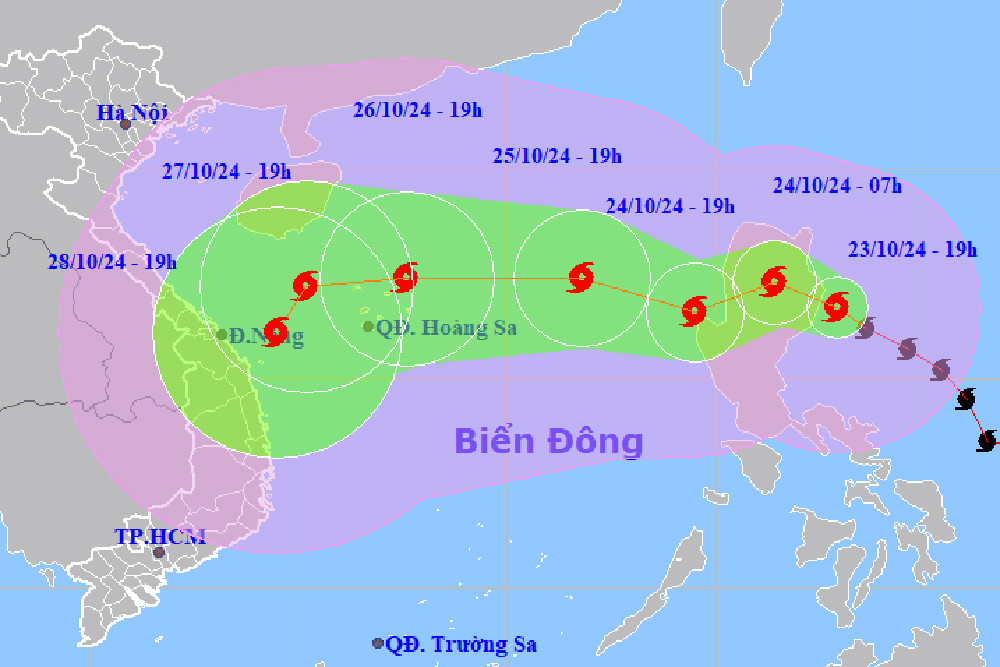
According to the meteorological agency, 24 hours later, the storm moved west-northwest again at a speed of 10-15km/h. At 7pm on October 25, the center of storm Tra Mi was in the eastern sea of the North East Sea, 580km east of Hoang Sa archipelago; wind intensity increased to level 10, gusting to level 12.
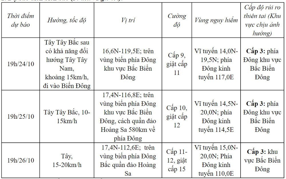
Notably, on October 26, the storm continued to increase in intensity, with level 11-12, gusting to level 15, and changed direction to move westward, at a speed of 15-20km/h. The center of the storm at 7:00 p.m. was in the sea northeast of the Hoang Sa archipelago.
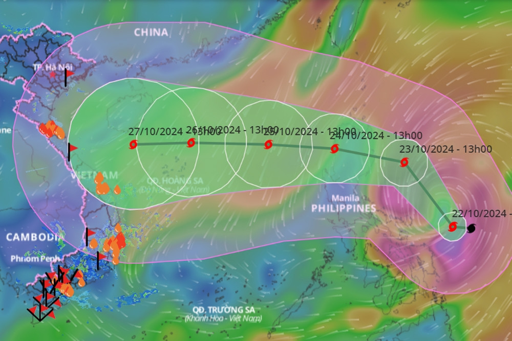
From the next 72 to 120 hours, the storm will move mainly in a westerly direction, traveling 10-15km per hour, then it will likely change direction to the South-Southwest and move more slowly.
Due to the influence of the storm, the East Sea area of the North East Sea has strong winds of level 6-7, near the storm center level 8-9 (62-88km/h), gusts of level 11, waves 3-5m high, near the storm center 5-7m; very rough seas.
The meteorological agency warns that ships operating in the above dangerous areas are likely to be affected by storms, whirlwinds, strong winds, and large waves.
According to Mr. Vu Anh Tuan, Deputy Head of Weather Forecast Department, National Center for Hydro-Meteorological Forecasting, due to the impact of the storm, from October 26-28, the Central provinces are likely to have widespread heavy rain.
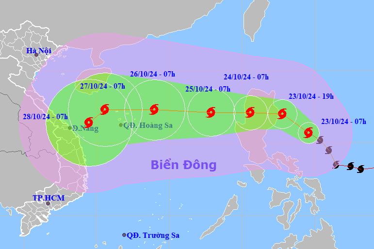
Storm Tra Mi is moving rapidly into the East Sea, possibly reaching maximum intensity of level 15.
Storm Tra Mi is likely to head towards the Central region, causing widespread heavy rain.
Source: https://vietnamnet.vn/bao-tra-mi-sap-vao-bien-dong-huong-di-chuyen-kha-hon-loan-2334891.html
![[Photo] Prime Minister Pham Minh Chinh meets the Vietnamese community in Malaysia](https://vphoto.vietnam.vn/thumb/1200x675/vietnam/resource/IMAGE/2025/5/25/1f11d1256d7745a2a22cc65781f53fdc)
![[Photo] President Luong Cuong receives Vice President of the Cambodian People's Party Men Sam An](https://vphoto.vietnam.vn/thumb/1200x675/vietnam/resource/IMAGE/2025/5/25/6f327406164b403a8e36e8ce9d3b2ad2)


![[Photo] President Luong Cuong receives Lao Vice President Pany Yathotou](https://vphoto.vietnam.vn/thumb/1200x675/vietnam/resource/IMAGE/2025/5/25/958c0c66375f48269e277c8e1e7f1545)
![[Photo] Memorial service for former President Tran Duc Luong in Ho Chi Minh City](https://vphoto.vietnam.vn/thumb/1200x675/vietnam/resource/IMAGE/2025/5/25/c3eb4210a5f24b6493780548c00e59a1)


Comment (0)