
 |
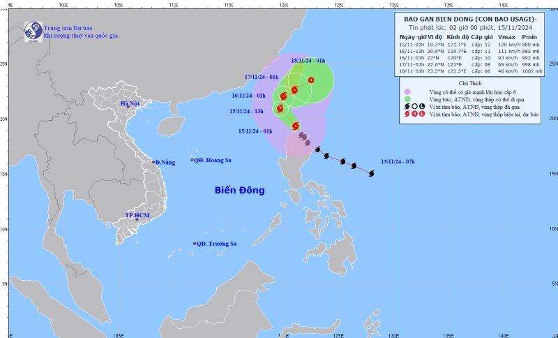
| Location and direction of storm Usagi. Photo: Center for Hydro-Meteorological Forecasting |
According to the National Center for Hydro-Meteorological Forecasting, on the night of November 14, storm No. 8 weakened into a tropical depression in the northern waters of the North East Sea.
At 1:00 a.m. on November 15, the center of the tropical depression was at about 21.1 degrees North latitude; 113.2 degrees East longitude, in the northern sea area of the North East Sea. The strongest wind near the center of the tropical depression was level 6 (39-49 km/h), gusting to level 8; moving westward at a speed of about 5 km/h.
At 1:00 p.m. on November 15, the center of the tropical depression was at about 20.6 degrees North latitude; 112.9 degrees East longitude, in the northwest sea of the North East Sea. The strongest wind near the center of the tropical depression was below level 6 (39-49 km/h); moving southwest at a speed of about 5 km/h, weakening into a low pressure area. The northwest sea of the North East Sea had a level 3 natural disaster risk.
At sea, on November 15, the northwest sea area of the North East Sea has strong winds of level 6, gusts of level 8, waves 2-3m high; rough seas. Ships operating in the above-mentioned dangerous area are likely to be affected by storms, whirlwinds, strong winds, and big waves.
Regarding the development of storm Usagi near the East Sea, early morning of November 15, the storm moved northwest at a speed of about 15 km/h.
At 1:00 a.m. on November 15, the center of the storm was located at approximately 19.3 degrees North latitude; 121.1 degrees East longitude, in the sea north of Luzon Island (Philippines). The strongest wind near the center of the storm was level 12 (118-133 km/h), gusting to level 15; moving northwest at a speed of approximately 15 km/h.
At 1:00 a.m. on November 16, the center of the storm was at about 22 degrees North latitude; 120 degrees East longitude, in the northeastern sea of the East Sea. The strongest wind near the center of the storm was level 10, gusting to level 12. Storm Usagi moved northwest at a speed of about 15 km/h, entering the northeastern sea of the North East Sea. The northeastern sea of the North East Sea had a level 3 natural disaster risk.
At 1:00 a.m. on November 17, the center of the storm was at approximately 22.6 degrees North latitude; 121 degrees East longitude, on the mainland south of Taiwan (China). The strongest wind near the center of the storm was level 8, gusting to level 10; moving northeast at a speed of approximately 10 km/h. The northeastern sea area of the North East Sea was at level 3 natural disaster risk.
At 1:00 a.m. on November 18, the center of the storm was located at approximately 23.5 degrees North latitude; 122.5 degrees East longitude, in the sea east of Taiwan (China). The strongest wind near the center of the storm was level 6, gusting to level 8. Storm Usagi moved northeast at a speed of approximately 10 km/h.
At sea, on the day and night of November 15, the northeastern sea area of the North East Sea will have strong winds of level 8-9, near the storm's eye level 10-11, gusting to level 14, waves 3-5 m high, near the eye 5-7 m; rough seas. Ships operating in the above-mentioned dangerous areas are likely to be affected by storms, whirlwinds, strong winds, and large waves.
The North continues to be sunny, with cold nights and early mornings.
Forecast for the day and night of November 15, the Northwest region will be cloudy, sunny during the day, no rain at night, some places will have fog in the early morning. Light wind, cold in the early morning and at night. Lowest temperature 20-23 degrees Celsius, some places below 19 degrees Celsius. Highest temperature 29-32 degrees Celsius, some places above 32 degrees Celsius.
Northeast region is cloudy, sunny during the day, no rain at night, early morning fog and light fog scattered. Light wind, early morning and night cold. Lowest temperature 21-24 degrees Celsius, mountainous areas have places below 20 degrees Celsius. Highest temperature 29-32 degrees Celsius, some places above 32 degrees Celsius.
Hanoi capital is cloudy, sunny during the day, no rain at night, early morning fog and light fog scattered. Light wind, early morning and night cold. Lowest temperature 22-24 degrees Celsius. Highest temperature 30-32 degrees Celsius.
Provinces from Thanh Hoa to Thua Thien - Hue have clouds, sunny days, some rain at night, early morning fog and light fog scattered. Light wind, cold in the North early morning and night. Lowest temperature 22-25 degrees Celsius. Highest temperature 29-32 degrees Celsius.
Provinces and cities from Da Nang to Binh Thuan have clouds, sunny days, some rain at night; light wind. Lowest temperature 22-25 degrees Celsius. Highest temperature 30-33 degrees Celsius.
The Central Highlands region is cloudy, sunny during the day, with showers and thunderstorms in some places in the evening and at night; light wind. Lowest temperature 19-22 degrees Celsius. Highest temperature 29-32 degrees Celsius.
The Southern region is cloudy, sunny during the day, with showers and thunderstorms in some places in the evening and at night; light wind. The lowest temperature is 24-27 degrees Celsius. The highest temperature is 30-33 degrees Celsius, some places are over 33 degrees Celsius./.


Comment (0)