
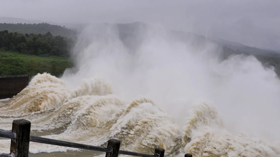
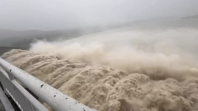
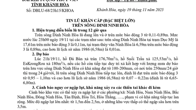
In the next 12-24 hours, floods on Kon River and Ba River will fluctuate at very high levels and above alert level 3; Krong Ana River ( Dak Lak ) will continue to rise and above alert level 2; floods on Thu Bon River and Tra Khuc River will continue to fall and at alert level 1-alarm level 2.
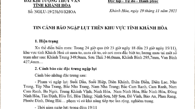
Warning: In the next 24 hours, floods on Huong River, Bo River, Vu Gia River, Srepok River will fluctuate at alert level 1-alarm 2 and above alert level 2; other rivers in Quang Ngai, Gia Lai , Dak Lak, Khanh Hoa will fluctuate at alert level 2-alarm 3, some rivers above alert level 3.
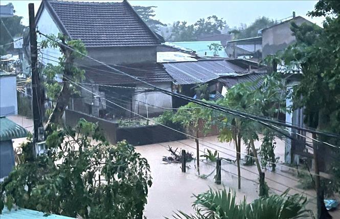
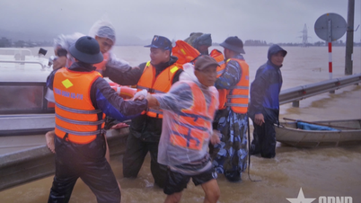
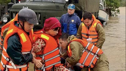
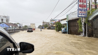
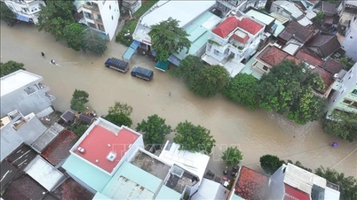
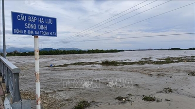
Widespread flooding occurs in provinces/cities from Hue city to Khanh Hoa . There is a high risk of flash floods on rivers and streams and landslides on slopes in provinces/cities from Hue city to Khanh Hoa. (Real-time warning information on flash flood and landslide risks is provided online on the website of the Department of Hydrometeorology at: https://luquetsatlo.nchmf.gov.vn and in the flash flood and landslide warning bulletin). Floods and inundation on rivers in the Central region are likely to last for many days.
The risk level of natural disasters due to floods, flash floods, and landslides in the eastern region of Dak Lak is level 4. River basins from Hue city to Khanh Hoa province are level 3.
"The forecast and warning information is calculated based on the expected operating level of upstream reservoirs. The hydrometeorological agency will update the bulletins when there are changes in the discharge flow of the reservoirs," noted Hoang Van Dai, Deputy Director of the National Center for Hydrometeorological Forecasting.
Floods on rivers and inundation in low-lying areas affect activities such as water transport, aquaculture, agricultural production, people's lives and socio-economic activities.
In addition, the National Center for Hydro-Meteorological Forecasting said that from 10:40 a.m. to 3:40 p.m. on November 19, the areas of Ha Tinh province and city and from Hue city to Khanh Hoa province will continue to have rain. There is a risk of flash floods and landslides in the above areas.
Specifically, the common accumulated rainfall in Ha Tinh and Hue city is from 10-30mm, some places over 50mm; Da Nang city and Quang Ngai from 20-40mm, some places over 80mm; Gia Lai and Khanh Hoa from 50-100mm, some places over 180mm; Dak Lak from 80-180mm, some places over 300mm.
Warning of the risk of flash floods on small rivers and streams, landslides on steep slopes in many communes and wards in provinces and cities such as Ha Tinh, Quang Ngai, Gia Lai, Dak Lak, Khanh Hoa, Hue, Da Nang. The level of risk of natural disasters due to flash floods, landslides, and land subsidence due to heavy rain or water flow is level 1; Da Nang city is level 2; Dak Lak is level 3.
Flash floods and landslides can have very negative impacts on the environment, threaten people's lives; cause local traffic congestion, affect the movement of vehicles; destroy civil and economic works, causing damage to production and socio-economic activities.
The hydrometeorological agency recommends that local authorities pay attention to reviewing bottlenecks and vulnerable locations in the area to have prevention and response measures.
At sea, in the North East Sea area, there are strong Northeast winds of level 7-8, gusting to level 9-10; At Bach Long Vy station, there are Northeast winds of level 7, sometimes level 8, gusting to level 9; at Hon Ngu station, there are strong Northeast winds of level 6, gusting to level 9; at Con Co station, there are strong Northeast winds of level 6, gusting to level 8; at Ly Son station, there are strong Northeast winds of level 6, sometimes level 7, gusting to level 9. The sea area to the west of the central East Sea area, the South East Sea area (including Truong Sa special zone), the sea area from South Quang Tri to Khanh Hoa and the Gulf of Thailand has scattered showers and thunderstorms.
Forecast, on the day and night of November 19, the North East Sea area (including Hoang Sa special zone) will have strong winds of level 7-8, gusts of level 9-10, rough seas, and waves 4-6m high.
Tonkin Gulf has strong winds of level 6-7, sometimes level 8, gusts of level 9-10, rough seas, waves 3-5m high.
The sea area from South Quang Tri to Quang Ngai and the sea area north of the central East Sea has strong winds of level 6, sometimes level 7, gusting to level 8-9, rough seas, waves 4-6m high.
The sea area from Gia Lai to Ho Chi Minh City has strong winds of level 6, gusts of level 7-8, rough seas, waves 3-5m high.
In addition, on the day and night of November 19, the central and southern East Sea (including Truong Sa special zone), the sea area from Quang Tri to Ca Mau, Ca Mau to An Giang and the Gulf of Thailand will have scattered showers and thunderstorms, with the possibility of tornadoes and strong gusts of wind of level 6-7.
Warning: During the day and night of November 20, the North East Sea area (including Hoang Sa special zone) will have strong Northeast winds of level 7-8, gusts of level 9-10, waves 4-6m high, rough seas; the Gulf of Tonkin and the sea area from Gia Lai to Ho Chi Minh City will have strong Northeast winds of level 6, gusts of level 7-8, waves 2-5m high, rough seas; the sea area from South Quang Tri to Quang Ngai and the sea area north of the central East Sea area will have strong Northeast winds of level 6, sometimes level 7, gusts of level 8-9, waves 4-6m high, rough seas; the sea area from Dong Thap to Ca Mau will have strong Northeast winds of level 5, sometimes level 6, gusts of level 7-8, waves 2-4m high, rough seas. Natural disaster risk level at sea is level 2.
All vessels operating in the above areas are at high risk of being affected by strong winds and large waves.
Source: https://baotintuc.vn/xa-hoi/canh-bao-lu-dac-biet-lon-tren-song-ba-dak-lak-lu-khan-tren-song-kon-gia-lai-20251119120103613.htm


![[Photo] The Standing Committee of the Organizing Subcommittee serving the 14th National Party Congress meets on information and propaganda work for the Congress.](https://vphoto.vietnam.vn/thumb/1200x675/vietnam/resource/IMAGE/2025/11/19/1763531906775_tieu-ban-phuc-vu-dh-19-11-9302-614-jpg.webp)


![[Photo] General Secretary To Lam receives Slovakian Deputy Prime Minister and Minister of Defense Robert Kalinak](https://vphoto.vietnam.vn/thumb/1200x675/vietnam/resource/IMAGE/2025/11/18/1763467091441_a1-bnd-8261-6981-jpg.webp)
![[Photo] Prime Minister Pham Minh Chinh and his wife meet the Vietnamese community in Algeria](https://vphoto.vietnam.vn/thumb/1200x675/vietnam/resource/IMAGE/2025/11/19/1763510299099_1763510015166-jpg.webp)


Comment (0)