
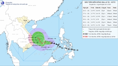
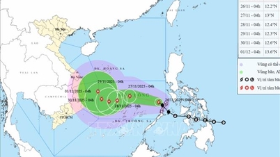
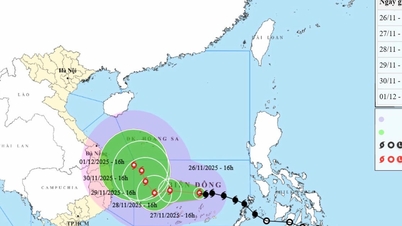
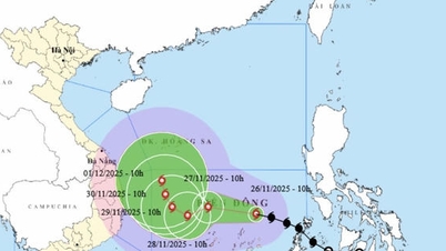
At 7:00 a.m. today, November 25, the center of the tropical depression was at about 10.3 degrees North latitude; 123.1 degrees East longitude, in the central region of the Philippines. The strongest wind near the center of the tropical depression was level 7 (50-61 km/h), gusting to level 9. Moving in the West Northwest direction at a speed of 20-25 km/h.
National Center for Hydro-Meteorological Forecasting forecasts in the next 24-48 hours:

From the next 48 to 72 hours, the storm will move mainly to the West, traveling 10-15km per hour and will continue to strengthen.
Due to the impact of the tropical depression that is likely to strengthen into a storm, from the evening of November 25, the sea area east of the Central East Sea and the sea area northeast of the South East Sea will have winds gradually increasing to level 6-7; the area near the storm center will have strong winds of level 8-9, gusting to level 11, waves 3.0-5.0m high. The sea will be very rough.
Warning: During the afternoon of November 26-28, the area between the Central East Sea and the northern waters of the Southern East Sea (including the northern waters of Truong Sa special zone) may be affected by strong winds of level 10-11, gusting to level 14.
Vessels operating in the above mentioned dangerous areas are susceptible to the impact of storms, whirlwinds, strong winds and large waves.
Source: https://baophapluat.vn/cap-nhat-moi-nhat-ap-thap-nhiet-doi-gan-bien-dong.html

![[Photo] VinUni students' emotions are sublimated with "Homeland in the Heart: The Concert Film"](/_next/image?url=https%3A%2F%2Fvphoto.vietnam.vn%2Fthumb%2F1200x675%2Fvietnam%2Fresource%2FIMAGE%2F2025%2F11%2F26%2F1764174931822_10-3878-jpg.webp&w=3840&q=75)


![[Photo] Close-up of heavy damage at the school located on the banks of the Ban Thach River](/_next/image?url=https%3A%2F%2Fvphoto.vietnam.vn%2Fthumb%2F1200x675%2Fvietnam%2Fresource%2FIMAGE%2F2025%2F11%2F26%2F1764152130492_ndo_bl_img-8188-8805-jpg.webp&w=3840&q=75)


![[Photo] Opening of the 28th Session of the Hanoi People's Council](https://vphoto.vietnam.vn/thumb/402x226/vietnam/resource/IMAGE/2025/11/26/1764155991133_image.jpeg)


Comment (0)