

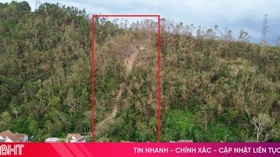
Due to the impact of the storm, the eastern part of Quang Ngai and Gia Lai provinces will be affected by strong winds and heavy rains starting from this afternoon until November 7 in the above area, causing a high risk of flash floods and landslides in the western mountainous areas of Quang Ngai and Gia Lai. In addition, the coastal area from Quang Ngai to Gia Lai will have very large waves.
Due to the storm's influence, at Ly Son station (Quang Ngai), there were strong winds of level 7, gusts of level 9; Dung Quat (Quang Ngai) strong winds of level 6, gusts of level 8; Phu Cat (Gia Lai) strong winds of level 7, gusts of level 10; Hoi An (Da Nang) strong winds of level 8, gusts of level 9.
At 1:00 p.m. on November 6, the center of the storm was at about 13.3 degrees North latitude; 110.8 degrees East longitude, about 190 meters East Southeast of Quy Nhon (Gia Lai). The strongest wind near the center of the storm was level 14-15 (150-183 km/h), gusting over level 17. Moving in the West Northwest direction, speed 25-30 km/h
At 7:00 p.m. on November 6, the storm in the coastal area from Quang Ngai to Dak Lak , the strongest wind speed is level 13, gusting to level 15, moving in the West Northwest direction at a speed of 25 - 30 km/h, entering the mainland and gradually weakening. The affected area is the West of the central East Sea, the sea area from Quang Ngai to Dak Lak (including Ly Son special zone); the mainland in the East of the area from Quang Ngai to Gia Lai, the North of Dak Lak, the natural disaster risk level is level 4. The sea area from South Quang Tri to Da Nang city (including Cu Lao Cham island) and Khanh Hoa; the mainland in South Quang Tri to Da Nang city, the South of Dak Lak province and the North of Khanh Hoa province with the natural disaster risk level is level 3.
Forecast, by 1:00 a.m. on November 7, the storm on the mainland from Quang Ngai to Dak Lak, the strongest wind is level 8-9, gusting to level 11, moving in the West Northwest direction at a speed of 25-30 km/h, going deep into the mainland and gradually weakening. The affected area is the sea from Quang Ngai to Dak Lak (including Ly Son special zone); the mainland to the East of the area from Quang Ngai to Gia Lai, the North of Dak Lak, level 4 disaster risk; the sea from South Quang Tri to Da Nang city (including Cu Lao Cham island) and Khanh Hoa; the mainland to South Quang Tri to Da Nang city, the South of Dak Lak province and the North of Khanh Hoa province with level 3 disaster risk.
Then, at 13:00 on November 7, the storm in the eastern part of Thailand, moved in the West-Northwest direction at a speed of 25-30 km/h, wind speed below level 6 and weakened into a low pressure area. The affected area is the sea from South Quang Tri to Da Nang city (including Cu Lao Cham island) and Khanh Hoa, mainland South Quang Tri to Da Nang city, west of Quang Ngai and Gia Lai provinces, east of Dak Lak province and north of Khanh Hoa province with level 3 natural disaster risk level.
Due to the influence of the storm, the sea area west of the central East Sea has strong winds of level 8-12; the area near the storm's eye has strong winds of level 13-15, gusting over level 17, waves 6-8m high, the area near the storm's eye has waves of 9-11m high; the sea is very rough.
The sea area from South Quang Tri to Khanh Hoa (including Ly Son special zone, Cu Lao Cham island) will have winds gradually increasing to level 7-8, then increasing to level 9-12, waves 4-7m high; the area near the storm center will have winds of level 13-15, gusting above level 17, waves 8-10m high; the sea will be very rough.
The highest sea level in Thuan An is 1m, Son Tra is 1.2m, Hoi An is 1.3m, Dung Quat is 1.5m, Quy Nhon is 1.2m, Tuy Hoa is 1.1m. All ships, boats, and aquaculture areas in the above-mentioned dangerous areas are strongly affected by storms, whirlwinds, strong winds, big waves, and rising sea levels.
From the south of Da Nang city to Dak Lak, the wind will gradually increase to level 6-7, then increase to level 8-9, the area near the storm center will be strong at level 10-13 (focusing on the east of Quang Ngai-Gia Lai provinces, north of Dak Lak), gusting at level 15-16. The area from the south of Quang Tri to the north of Da Nang city and the north of Khanh Hoa province will have strong winds at level 6-7, gusting at level 8-9. The strongest wind will be from the evening to the night of November 6.
From the evening of November 6, in the West of the provinces from Quang Ngai to Gia Lai, the wind will gradually increase to level 6-7, near the storm's eye, it will be level 8-9, gusting to level 11.
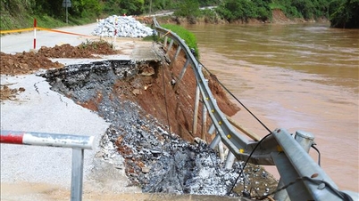
From the afternoon of November 6-7, the area from Da Nang City to Dak Lak will have very heavy rain with common rainfall of 200-400 mm/period, locally over 600 mm/period; the area from South Quang Tri to Hue City, Khanh Hoa and Lam Dong will have heavy rain with common rainfall of 150-300 mm/period, locally over 450 mm/period. From November 8, heavy rain in the above areas will tend to decrease.
From November 7-8, the area from North Quang Tri to Thanh Hoa will have moderate to heavy rain with common rainfall of 50-150 mm/period, locally very heavy rain over 200 mm/period. Warning of risk of heavy rain over 200 mm/3 hours.
Source: https://baotintuc.vn/xa-hoi/du-bao-bao-so-13-duy-tri-cuong-do-manh-nhat-trong-khoang-46-gio-toi-20251106153344537.htm
![[Photo] Prime Minister Pham Minh Chinh receives the delegation of the Semiconductor Manufacturing International (SEMI)](https://vphoto.vietnam.vn/thumb/1200x675/vietnam/resource/IMAGE/2025/11/06/1762434628831_dsc-0219-jpg.webp)


![[Photo] Hanoi: Long Bien residents brave the rain to go to work and school amid traffic jams due to bridge closures from early morning](https://vphoto.vietnam.vn/thumb/1200x675/vietnam/resource/IMAGE/2025/11/07/1762485038077_dji-0206-1506-jpg.webp)


Comment (0)