

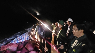
Km1136+850 in the Phuoc Lanh-Van Canh section experienced the most serious landslide with an average depth of about 9m - Photo: VNR
The railway has a washed-out roadbed, and there is no official opening date yet.
Vietnam Railways Corporation (VNR) said that due to the impact of storm No. 13 (Kalmaegi) causing heavy rain and strong winds in the area from Quang Ngai to Tuy Hoa, as of this morning (November 7), some railway sections have been damaged, causing disruptions to train operations. It is expected that today, the railway industry will organize the transfer of about 1,500 passengers on trains passing through the area, from Tuy Hoa station (Dak Lak) to Dieu Tri station (Gia Lai).
Preliminary statistics from Vietnam Railways Corporation show that storm No. 13 caused severe damage to the railway infrastructure on the Hanoi - Ho Chi Minh City railway line, of which Km1136+850 in the Phuoc Lanh - Van Canh section experienced the most serious landslide with an average depth of about 9m. In addition, many railway sections had their rock foundations washed away, trees fell across, signal poles were broken, the national grid was cut off, leading to loss of communication and dispatch, and many signal communication devices were paralyzed due to flooding...

Due to the deep roadbed and strong water flow, railway repair and restoration will depend on weather conditions and water collection capacity, so there is no official time for the route to be opened.
Currently, the railway industry is urgently repairing the landslides. Due to the deep roadbed and strong water flow, the repair and restoration of the railway will depend on weather conditions and the ability to collect water, so there is no official time for the line to be opened.
In addition, the Railway sector has created conditions for passengers in the area affected by storm No. 13 to return their tickets free of charge. Specifically, passengers with tickets for even-numbered trains passing through Tuy Hoa station, passengers with tickets for odd-numbered trains passing through Dieu Tri station on November 7-8.

Dak Po To Bridge (Km378+130) on Truong Son Dong Road was swept away by floodwaters. Photo: T.Hong
Fallen trees and landslides block the Central Highlands highway
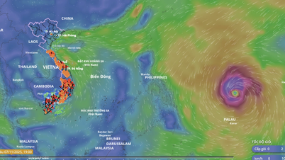
According to the Vietnam Road Administration, after making landfall early this morning (November 7), storm No. 13 weakened into a low pressure area in the Lower Laos region. Provinces from Ha Tinh to Da Nang have moderate winds and rain, with some heavy rain. The eastern provinces from Quang Ngai to Dak Lak have heavy rain and strong winds; after the storm, there will still be rain due to the influence of the storm's circulation.
For the road area managed by the Central Government: The West branch of Ho Chi Minh Road still has 5 traffic jams: at Km396+050, Km407+460, Km407+950, Km408+040, Km408+350. It is expected to open to traffic today (November 7). Of which, the location of Km396+050, where the bridge is damaged, has been declared an emergency situation due to natural disasters by the Ministry of Construction.
Many trees, electric poles fell onto the road, corrugated iron roofs and objects flew onto the road, especially on National Highway 1 (QL1) and Truong Son Dong Road in Gia Lai and Dak Lak provinces in the eye of the storm; in particular, on QL1 through Song Cau, Tuy An, Dong Hoa (Dak Lak province) and on Truong Son Dong Road (Gia Lai province), many trees fell, blocking traffic. Many places had power outages, and many road signs were broken. Currently, regular maintenance units have been cutting and clearing to promptly reopen the road.

Many national highways and expressways were flooded after storm No. 13. Photo: Vietnam Road Administration
Truong Son Dong Road at Dak Po To Bridge Km378+130 (Gia Lai Province) was swept away by floodwaters at the bridgehead near M1 pier, about 25m long and about 8m deep. Currently, the National Highway QLDB III has barricaded both ends and assigned guards, mobilized steel cages and boulders to repair the situation, and is expected to reopen to traffic this afternoon.
In addition, on Truong Son Dong road, there are many flooded areas causing serious traffic jams, including: Section Km390+500 - Km391+400 with water 0.8m deep, completely blocked the road; Section Km402 - Km402+700 and section Km404+100 - Km404+350 with water 0.7m deep, completely blocked the road. These flooded areas have been barricaded and posted with road closure signs by the road management unit, and informed to the locality.
On National Highway 1 through Quang Ngai, trees have fallen, creating more potholes on the road surface. Some lighting poles on the bridge have tilted, broken the bridge railing, and the negative slope has collapsed, causing the corrugated iron guardrail at Km1119 to sag about 50m long (already barricaded). At Km1121+850/National Highway 1 (near Chau Me), the water level is 15cm - 30cm, vehicles are moving slowly, and forces are continuing to monitor to warn and regulate if the water continues to rise deeper.
In addition, the Vietnam Road Administration reported that national highways managed by localities have suffered a lot of damage, such as: Km82 section on National Highway 40B has been eroded, causing traffic jams (expected to open today); National Highway 15D Dakrong/Km0+30 is flooded 0.5m, causing traffic jams; National Highway 49C still has 2 locations flooded 0.2m...
Phan Trang
Source: https://baochinhphu.vn/duong-sat-te-liet-nhieu-tuyen-quoc-lo-qua-mien-trung-tay-nguyen-ngap-nuoc-102251107140452567.htm


![[Photo] Da Nang: Hundreds of people join hands to clean up a vital tourist route after storm No. 13](https://vphoto.vietnam.vn/thumb/1200x675/vietnam/resource/IMAGE/2025/11/07/1762491638903_image-3-1353-jpg.webp)


Comment (0)