
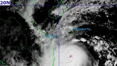
At 4:00 p.m. the same day, storm No. 13 was about 120km east of Quy Nhon ( Gia Lai ). The central East Sea area, the sea area from Quang Ngai to Dak Lak (including Ly Son special zone) was warned of level 4 risk. The sea area from South Quang Tri to Da Nang city (including Cu Lao Cham island) and Khanh Hoa; mainland South Quang Tri to Da Nang city, the east of the provinces from Quang Ngai to Dak Lak and the north of Khanh Hoa province was warned of level 3 risk.

Due to the storm's influence, the Central East Sea area has strong winds of level 8-11; the area near the storm's eye has strong winds of level 12-14, gusts of level 17, waves 5.0-7.0m high, the area near the storm's eye has waves of 8.0-10.0m high; the sea is very rough.
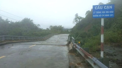
From this morning, the sea area from South Quang Tri to Khanh Hoa (including Ly Son special zone, Cu Lao Cham island) has gradually increased to level 6-7, then increased to level 8-11, waves 3.0-6.0m high; the area near the storm center has strong winds of level 12-14, gusts of level 17, waves 7.0-9.0m high; the sea is very rough. The coastal area from Hue city to Dak Lak has storm surges of 0.4-0.8m high, which can cause flooding in low-lying areas, waves overflowing dikes, coastal roads, coastal landslides, slowing down flood drainage in the area. All ships, boats, and aquaculture areas in the above-mentioned dangerous areas are strongly affected by storms, whirlwinds, strong winds, big waves, and rising sea levels.
In addition, the area from Da Nang City to Dak Lak has very heavy rain with common rainfall of 200-400mm/period, locally over 600mm/period; the area from South Quang Tri to Hue City, Khanh Hoa and Lam Dong has heavy rain with common rainfall of 150-300mm/period, locally over 450mm/period. From November 8, heavy rain in the above areas tends to decrease.
Weather nationwide on Thursday (November 6), Hanoi capital is cloudy, no rain, sunny in the afternoon. North to northeast wind level 2-3. Cold morning and night. Lowest temperature 19-21 degrees. Highest temperature 25-27 degrees.
Northwest region is cloudy with rain in some places, sunny in the afternoon. Light wind. Cold in the morning and at night. Lowest temperature 18-21 degrees, some places below 17 degrees. Highest temperature 25-28 degrees.
Northeast region is cloudy with rain in some places, sunny in the afternoon. North to northeast wind level 2-3. Cold in the morning and at night. Lowest temperature 18-21 degrees, in mountainous areas below 17 degrees. Highest temperature 24-27 degrees, in some places above 27 degrees.
From Thanh Hoa to Hue, it is cloudy. In the North, there will be some rain during the day and scattered rain at night. In the South, there will be showers and thunderstorms, with some places having heavy rain. From the afternoon, there will be moderate rain, heavy rain and thunderstorms, and some places having very heavy rain. The wind from the north to the northwest is level 3; in the South, from the evening, the wind will gradually increase to level 6-7, gusting to level 8-9. The morning and night will be cold. During thunderstorms, there is a possibility of tornadoes, lightning, and strong gusts. The lowest temperature is 19-22 degrees. The highest temperature is 24-27 degrees.
The South Central Coast is cloudy with showers and thunderstorms, with some places experiencing heavy rain; from the afternoon there will be heavy to very heavy rain. The northwest wind will be level 3-4, gradually increasing to level 6-7 from the evening, then increasing to level 8-9, near the storm center level 10-12, gusting to level 14-15. During thunderstorms, there is a possibility of tornadoes, lightning and strong gusts of wind. The lowest temperature is 22-25 degrees. The highest temperature in the North is 24-26 degrees; in the South is 27-29 degrees.
The Central Highlands is cloudy with showers and thunderstorms, with some places experiencing heavy rain; from the afternoon there will be heavy to very heavy rain. Northwest wind level 3-4, especially in the North from the evening the wind will gradually increase to level 6-7, near the storm center level 8-9, gusting to level 11. During thunderstorms there is a possibility of tornadoes, lightning and strong gusts. Lowest temperature 19-22 degrees. Highest temperature 23-26 degrees.
The South is cloudy with scattered showers and thunderstorms; in the afternoon and evening there will be scattered showers and thunderstorms, with some heavy rain. Light wind. During thunderstorms there is a possibility of tornadoes, lightning and strong gusts of wind. Lowest temperature 23-26 degrees. Highest temperature 29-32 degrees.
Ho Chi Minh City is cloudy with scattered showers and thunderstorms; in the afternoon and evening there will be scattered showers and thunderstorms, with some heavy rain in some places. Light wind. During thunderstorms there is a possibility of tornadoes, lightning and strong gusts of wind. Lowest temperature 23-25 degrees. Highest temperature 30-32 degrees.
Source: https://cand.com.vn/doi-song/ha-noi-nang-dep-mien-trung-don-bao-troi-mua-to-i787136/


![[Photo] Closing of the 14th Conference of the 13th Party Central Committee](https://vphoto.vietnam.vn/thumb/1200x675/vietnam/resource/IMAGE/2025/11/06/1762404919012_a1-bnd-5975-5183-jpg.webp)


Comment (0)