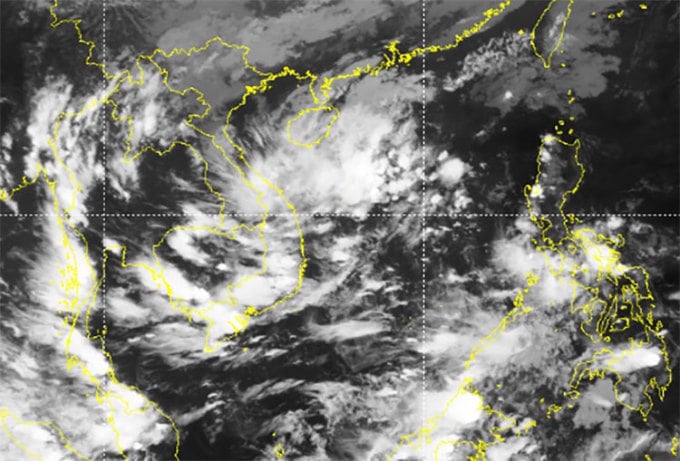
Due to the appearance of a low pressure area in the East Sea, the rain in the Central region will last for many days and expand to the North Central region, Kon Tum , Gia Lai, Quang Ngai, Binh Dinh.
The Central region has entered its fifth day of heavy rain. According to the meteorological agency, from 7pm on October 10 to 7am today, Thua Thien Hue, Da Nang, Quang Nam had widespread rain of 400-600mm, with some places receiving over 1,000mm. Provinces from Ha Tinh to Quang Tri had widespread rain of 200-400mm, concentrated in the plains and coastal areas.
Rainfall at some stations exceeded 1,000 mm, such as Hoa Khe ( Da Nang ) over 1,050 mm, Quan Tuong Dai (Thua Thien Hue) 1,005 mm. This is the reason why Da Nang and Thua Thien Hue have had a series of deep flooding spots, low-lying areas flooded up to 1.5 m, people's lives have been turned upside down over the past two days.
By this morning, the rain had stopped, and Da Nang still had some flooded areas in Thanh Khe, Lien Chieu and Hoa Vang districts. In Thua Thien Hue, the flood had receded from people's houses, leaving only flooded fields in Phong Dien, Quang Dien and part of Phu Loc districts.

Flooding in Da Nang, evening of October 13. Photo: Nguyen Dong
Mr. Nguyen Van Huong, Head of Weather Forecasting Department, National Center for Hydro-Meteorological Forecasting, explained that heavy rain in the Central region in recent days was due to the impact of three typical rain-causing forms: cold air, tropical convergence zone and easterly wind developing at 1,500-5,000 m bringing moisture from the East Sea.
It is forecasted that in the next three days, rain-causing patterns in the Central region will continue to be active, with cold air strengthening today and tomorrow.
"In addition, we are monitoring the low pressure area in the middle of the East Sea moving towards the Central mainland," Mr. Huong said, adding that this low pressure area is likely to strengthen, causing more severe rain in the Central region.

Satellite cloud images at 10am this morning show the low pressure area (white) in the middle of the East Sea is moving towards the Central region. Photo: NCHMF
With the above impacts, the meteorological agency forecasts that the Central region will continue to have heavy rains in the coming days, with changing rainfall patterns. Today, the rain will concentrate from Quang Tri to Quang Nam, then expand to Binh Dinh, northern Kon Tum, and Gia Lai.
Specifically, in the next three days, the area from Quang Binh to Binh Dinh will have widespread rain of 150-250 mm, some places over 400 mm; in Thua Thien Hue, Da Nang, Quang Nam 250-450 mm, some places over 800 mm; Ha Tinh 50-100 mm, some places over 150 mm.
During the period of October 16-18, when the low pressure area enters the mainland and combines with strong southeast winds, the rain area will expand to the North Central region (Thanh Hoa to Quang Tri).
Floods have occurred on rivers from Ha Tinh to Quang Ngai. Flood peaks in the upper reaches of La River (Ha Tinh), rivers from Quang Binh, Quang Ngai have reached alert levels 1-2, rivers in Quang Tri, Thua Thien Hue, Quang Nam have reached alert levels 2-3 (highest alert level 3). There is a risk of flash floods and landslides in mountainous areas, flooding in low-lying areas along rivers and urban areas in provinces from Ha Tinh to Quang Ngai.
The National Steering Committee for Natural Disaster Prevention and Control said that heavy rains and floods in the past few days have killed two people in Ha Tinh and Thua Thien Hue. More than 1,500 houses were flooded, mainly in Da Nang. Hundreds of traffic points in Quang Binh, Thua Thien Hue, and Da Nang were flooded and isolated, and more than 67 hectares of crops were flooded.
Source link


![[Photo] National Assembly Chairman attends the seminar "Building and operating an international financial center and recommendations for Vietnam"](https://vphoto.vietnam.vn/thumb/1200x675/vietnam/resource/IMAGE/2025/7/28/76393436936e457db31ec84433289f72)


Comment (0)