
Latest tropical depression news
Latest tropical depression news from the National Center for Hydro-Meteorological Forecasting: At 1:00 p.m. on September 17, the center of the tropical depression was located at about 16.8 degrees North latitude; 119.0 degrees East longitude, in the eastern sea of the North East Sea, about 820km east of Hoang Sa archipelago. The strongest wind near the center of the tropical depression is level 7 (50-61km/h), gusting to level 9; moving mainly westward at a speed of about 25km/h.
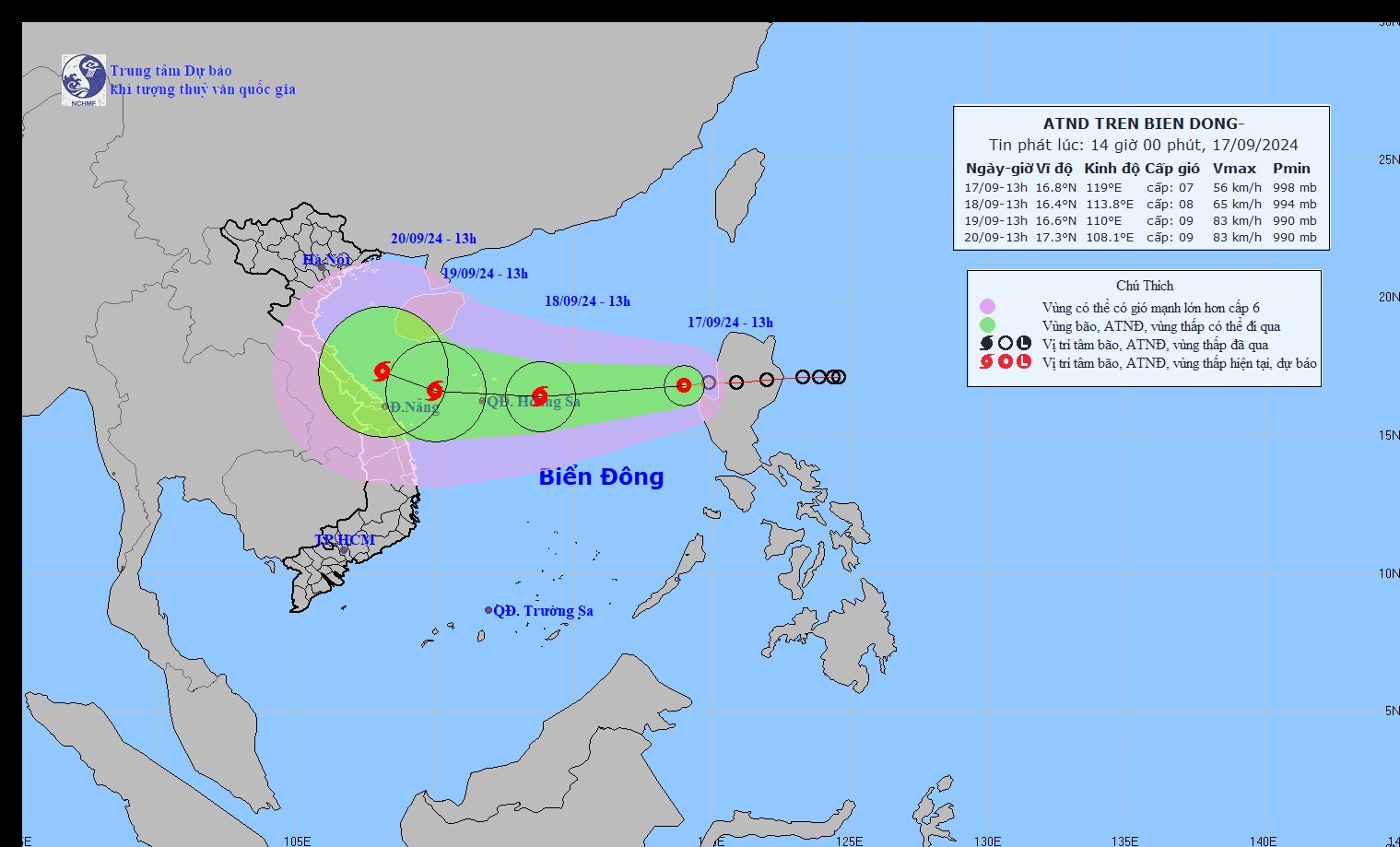
Update on the location and path of the tropical depression. Photo: NCHMF
It is forecasted that in the next 24 to 48 hours, the tropical depression is likely to strengthen into a storm, level 8-9 intensity, gusting to level 10-11.
Forecast time | Direction, speed | Location | Intensity | Danger zone | Disaster Risk Level (Affected Area) |
13h/18/9 | West Southwest, about 20-25km/h, strengthening into a storm | 16.4 N-113.8E; about 240km east of Hoang Sa archipelago | Level 8, level 10 jerk | 15.0N-19.0N; East of longitude 112.5E | Level 3: North East Sea area |
13h/19/9 | West, 15-20km/h | 16.6N-110.0E; about 250km East Southeast from the mainland of Quang Binh to Da Nang provinces | Level 8-9, jerk level 11 | 15.0N-19.0N; 108.5E-115.0E | Level 3: North East Sea area (including Hoang Sa archipelago area); sea area from Quang Binh to Quang Ngai |
In the next 48 to 72 hours, the storm is likely to change direction, moving in a West Northwest direction, traveling about 10 km per hour .
On the impact of tropical depressions/storms
At sea: The North East Sea has strong winds of level 6-7, near the storm center level 8 (62-74km/h), gusts of level 10 (89-102km/h), rough seas.
Rising water, big waves: In the North East Sea, waves are 2.0-4.0m high, near the storm center, 3.0-5.0m high. Ships operating in the above-mentioned dangerous areas are likely to be affected by strong winds and big waves.
Proactively respond to tropical depression that is likely to strengthen into storm No. 4
From now until the end of September, there is a possibility of 1-2 storms appearing in the East Sea (likely concentrated in the last 10 days of September) and they may affect the Northern and North Central regions. There is a high risk of heavy rain and floods in the Central region during the rainy season in October-November 2024.
To proactively respond to the tropical depression that is likely to strengthen into a storm, the Prime Minister has sent telegram 97 to the Chairmen of the People's Committees of the following provinces and cities: Quang Ninh, Hai Phong, Thai Binh, Nam Dinh, Ninh Binh, Thanh Hoa, Nghe An, Ha Tinh, Quang Binh, Quang Tri, Thua Thien Hue, Da Nang, Quang Nam, Quang Ngai, Binh Dinh, Phu Yen, Khanh Hoa; and the Ministers of Agriculture and Rural Development, Natural Resources and Environment, Transport, Industry and Trade, National Defense, and Public Security. The specific contents of telegram 97 are as follows:
According to the bulletin of the National Center for Hydro-Meteorological Forecasting, this morning (September 17, 2024), the tropical depression crossed Ludong Island (Philippines) into the eastern sea of the northern East Sea; at 10:00 a.m. this morning, the center of the tropical depression was at about 16.9 degrees North latitude, 119.9 degrees East longitude, the strongest wind near the center of the storm was level 7, gusting to level 9. The tropical depression is forecast to move west at a speed of 20km/h towards the Hoang Sa archipelago and is likely to strengthen into a storm in the next 24 hours; the storm may directly affect the sea and mainland of our country, causing strong gusts and heavy rain in the Central Central and North Central regions in the coming days.
The development of this tropical depression is still very complicated (it is forecasted that wind level, speed and direction of movement may change).
To proactively respond to tropical depressions that are likely to strengthen into storms, especially the risk of heavy rain, flooding, landslides, flash floods, the Prime Minister requests:
Firstly, the Minister of Natural Resources and Environment directed the hydrometeorological forecasting agency to continue to closely monitor, forecast, and provide full and timely information on the developments of the tropical depression to authorities and people so that they can proactively deploy response work according to regulations.
Second, the Ministers of the Ministries and Chairmen of the People's Committees of the above-mentioned provinces and cities, according to their assigned functions and tasks, shall organize regular and continuous monitoring and updating of information on developments of tropical depressions, storms, and floods to proactively direct and deploy appropriate response work to natural disasters that may affect the management scope of the sector and locality, including:
- Focus on immediately implementing measures to ensure safety for ships, vehicles and activities at sea and along the coast.
- Review and complete response scenarios for tropical depressions, storms, floods, landslides, flash floods, focusing on ensuring safety of people's lives and limiting damage to property, and scientifically and safely operating hydroelectric and irrigation dams.
- Proactively arrange forces, materials, and means, especially in localities expected to be directly affected by storms, floods, and key areas to be ready to respond to tropical depressions, storms, floods, and rescue when required.
Third, Vietnam Television, Voice of Vietnam and other media agencies should increase broadcasting time and report news so that people can grasp information about developments of tropical depressions, storms, floods, and instructions from competent authorities, and know how to respond to natural disasters, especially landslides, flash floods, and inundations, to limit damage.
Fourth, the Minister of Agriculture and Rural Development shall organize a 24/7 duty to closely monitor the situation, proactively direct and urge localities to deploy response work in accordance with actual natural disaster developments, promptly report and propose to the Prime Minister and Deputy Prime Minister to direct issues beyond their authority.
Fifth, the Government Office monitors and urges ministries and localities to seriously implement this Official Dispatch; promptly reports to the Prime Minister and Deputy Prime Minister in charge on urgent and arising issues...
Source: https://danviet.vn/tin-ap-thap-nhiet-doi-moi-nhat-ngay-mai-18-9-manh-len-thanh-bao-so-4-20240917142732023.htm
![[Photo] Pink ball and table tennis](https://vphoto.vietnam.vn/thumb/1200x675/vietnam/resource/IMAGE/2025/5/26/d9f770bdfda243eca9806ea3d42ab69b)


![[Photo] French President Emmanuel Macron and his wife begin state visit to Vietnam](https://vphoto.vietnam.vn/thumb/1200x675/vietnam/resource/IMAGE/2025/5/25/03b59c7613144a35ba0f241ded642a59)
![[Photo] Ea Yieng commune settlement project abandoned](https://vphoto.vietnam.vn/thumb/1200x675/vietnam/resource/IMAGE/2025/5/25/57a8177361c24ee9885b5de1b9990b0e)


![[Infographic] Vietnam-France Comprehensive Strategic Partnership](https://vphoto.vietnam.vn/thumb/402x226/vietnam/resource/IMAGE/2025/5/26/986f63068ea9413dbbb558ee6c6944f3)


Comment (0)