
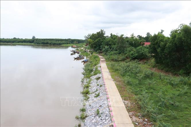
Thach Han is one of the major rivers of Quang Tri province, located in the south of the province with a length of 155 km, a basin area of up to more than 2,700 km2. This river has a large slope from West to East, high flow velocity combined with natural disasters occurring frequently in both frequency and intensity, making the situation of bank erosion increasingly serious. Along with human impacts such as construction of works, sand and gravel exploitation under the riverbed have also caused the erosion of both banks of Thach Han river to become complicated, especially in the rainy season.
The bank of Thach Han River through Quang Tri Ward and the communes of Trieu Phong, Ai Tu, and Trieu Binh has eroded over a length of more than 14 km, affecting many households and constructions. In Quang Tri Ward, the most seriously eroded bank of Thach Han River is in Nhu Le Village. In Ai Tu Commune, the bank of Thach Han River has seriously eroded through the villages of Dai Thuong Ha, An Dinh, Phu My Kien, Tra Lien Dong, and Tra Lien Tay. In Trieu Binh Commune, the bank of Thach Han River through Duong Dai Thuan Village has eroded over 500m...
An Mo Bridge connects the two banks of the Thach Han River in Trieu Phong and Ai Tu communes. The banks of the Thach Han River around the two abutments of An Mo Bridge have been seriously eroded, causing loss of land and threatening people's houses and constructions. From 2024 to early 2025, Quang Tri province will allocate tens of billions of VND to build embankments to prevent erosion of the Thach Han River banks on both sides of An Mo Bridge abutments. When completed, the embankments will not only prevent riverbank erosion but also create livelihoods for local people.
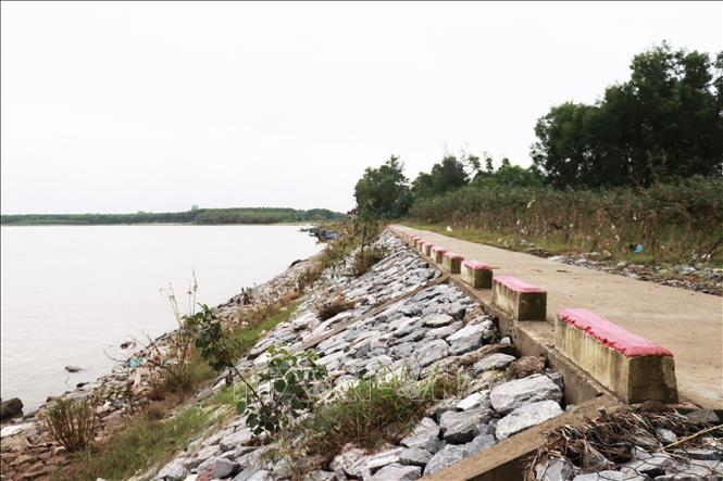
Mr. Nguyen Huu Tam, living on the banks of the Thach Han River in Ai Tu Commune, shared that in early November 2025, the flood on the Thach Han River rose high, but people were no longer as worried as before, because there was a river embankment to prevent riverbank erosion. The river embankment also creates a beautiful landscape and environment on both sides of the river. In addition, the river embankment is also a place to anchor boats and ships of households working in clam raking, fishing, and shrimping on the Thach Han River.
On the northern bank of the Thach Han River, passing through Tra Lien Tay village, Ai Tu commune, there are many landslides affecting 30 households and acacia and cajuput plantations. Since the beginning of 2025, these landslides have been repaired by embankments.
Mr. Tran Van Vinh, a local resident, said that the serious erosion of the Thach Han riverbank has caused local people to live in fear. The river embankment was built to help people feel secure in building houses and stabilizing production. The embankment also creates a landscape for people to walk, stroll or enjoy the cool breeze on the riverbank with fresh air.
According to the representative of the People's Committee of Ai Tu commune, the government regularly organizes inspections and reviews of the current status of riverbank erosion; develops and updates response plans to landslides suitable for each location; deploys safety measures to proactively handle emergency situations; and proposes that competent authorities pay attention to allocating resources to invest in building embankments to prevent landslides.
The banks of the Thach Han River are eroding almost vertically, every year the erosion is 5-10m deep into production land and residential land, damaging many structures, affecting the lives and activities of more than 5,000 households; of which, hundreds of households are currently living in a truly dangerous area, less than 20m from the riverbank.
Over the past years, Quang Tri province has invested hundreds of billions of VND to build embankments to prevent erosion on the banks of the Thach Han River; at the same time, contributing to creating the landscape. Typical examples include the embankment of the Thach Han River through Dong Ha and Nam Dong Ha wards; and the section of Trieu Binh, Trieu Phong communes and Quang Tri ward.
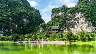
Thach Han is also a river closely associated with the life and history of the people of Quang Tri - for many years it has been regularly affected by floods and serious landslides. Many sections of the riverbank have been eroded, threatening houses, production land and people's infrastructure. Faced with this situation, embankment projects to prevent landslides on the Thach Han riverbank have been implemented, bringing about clear effects in both natural disaster prevention and local socio -economic development. Not only helping to stabilize the flow and protect hundreds of households along the river, the embankment system also contributes to urban beautification, creating a new look for Dong Ha city and surrounding areas.
Along the embankments, many localities along the Thach Han River have planned walking paths, planted trees, formed community living spaces, riverside parks, creating clean and beautiful landscapes and attracting tourists. Thanks to that, the river embankment project not only plays a protective role, but also brings "double benefits" of both maintaining safety and promoting the development of living space.
In addition, the combination of ecological embankments with native tree planting helps to limit erosion, improve the water environment and preserve the natural ecosystem. People are also increasingly aware of protecting the river, preserving the landscape and joining hands for sustainable development.
Source: https://baotintuc.vn/kinh-te/quang-tri-thuc-hien-da-muc-tieu-xay-dung-ke-bao-ve-bo-song-thach-han-20251115134018942.htm
![[Photo] General Secretary To Lam receives Governor of Kanagawa Province (Japan) Kuroiwa Yuji](https://vphoto.vietnam.vn/thumb/1200x675/vietnam/resource/IMAGE/2025/11/15/1763204231089_a1-bnd-7718-5559-jpg.webp)
![[Photo] Exciting contest of skillful red fruit picking and creativity from Son La coffee beans](https://vphoto.vietnam.vn/thumb/1200x675/vietnam/resource/IMAGE/2025/11/15/1763201832979_ndo_bl_3-jpg.webp)
![[Photo] Action for the Community tells stories of enduring journeys – both intimate and great, yet quiet and determined](https://vphoto.vietnam.vn/thumb/1200x675/vietnam/resource/IMAGE/2025/11/15/1763179022035_ai-dai-dieu-5828-jpg.webp)
![[Photo] The Government Standing Committee reviews the planning project of the Red River landscape avenue axis](https://vphoto.vietnam.vn/thumb/1200x675/vietnam/resource/IMAGE/2025/11/15/1763197032149_dsc-0163-jpg.webp)


Comment (0)