

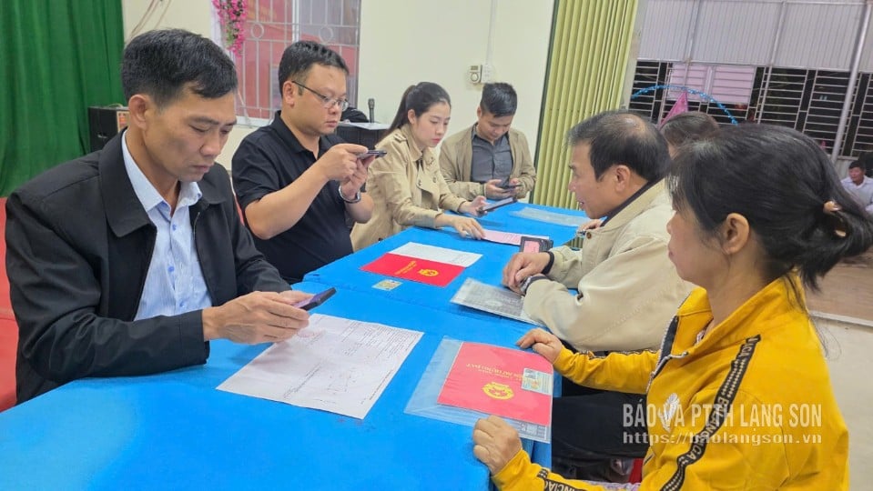
Reporter: Sir, could you briefly outline the outstanding results that Lang Son has achieved after the 90-day campaign to clean up and enrich the land database?
Mr. Trieu Duc Minh: In implementing Plan No. 515, the province has seriously deployed the 90-day campaign to enrich and clean up the land database with 4 groups of content and 12 specific tasks.
As a result, the province has basically completed the project on schedule and achieved many important targets. Specifically, the province has completed 100% of the land database update, transitioning from a three-tiered to a two-tiered government model; and simultaneously added land parcel identification codes to all parcels that already have data.
For areas where a database has not yet been established, the province has completed the creation of new land data for over 95% of land parcels. The verification and matching of information between the land database and the population database has reached over 96% of the land parcels requiring matching.
To date, over 34% of the land parcels in the province's database have been updated and completed, ensuring the criteria of "accurate - complete - clean - livable" (higher than the national average of 25%). In particular, the province has completed the connection and synchronization of 100% of its land data with the national land database system, ensuring sharing and interoperability with the national population database.
With these results, Lang Son was assessed by the Ministry of Agriculture and Environment as one of the 10 provinces and cities nationwide that effectively implemented the campaign.
PV: During the implementation process, what difficulties did the sector encounter, and what measures were taken to ensure progress, sir?
Mr. Trieu Duc Minh: Before launching the campaign, the entire province had built a cadastral and land database for more than 2.73 million land parcels, reaching over 77% of the total number of land parcels in the province. However, only about 16,000 parcels (0.6%) met the criteria of "correct - complete - clean - viable," while the remaining more than 99% needed to be adjusted, cleaned, and had information supplemented.
The biggest challenge is the change in administrative boundaries. From 2019 to the present, the province has reorganized its administrative units three times, reducing the number of commune-level administrative units from 226 to 65. This has necessitated updating and standardizing all cadastral maps, records, and data. Furthermore, the land database has been developed over several stages using different technologies, resulting in inconsistencies and many records remaining undigitized. Meanwhile, the workload is enormous, the timeframe is short, and the number of land parcels requiring data cleaning and citizen identification verification is overwhelming. In addition, in remote areas, people have limited economic and technological resources, making information dissemination and collection difficult. Moreover, the number of specialized personnel at the grassroots level is also insufficient.
Faced with these difficulties, the department proactively coordinated closely with relevant sectors and localities, strengthened technical guidance, monitored progress daily, and mobilized local professional forces to participate. From the beginning of the campaign, the Provincial People's Committee issued a decisive directive, identifying this as a key political task.
During the implementation process, many flexible and creative approaches were applied. At the departmental level, youth union members worked even on holidays; Zalo groups were established for each commune to exchange information and promptly address problems. At the commune level, many localities mobilized youth union members and non-specialized officials to participate in collecting, scanning, and entering data, making a significant contribution to the overall results of the entire province.

PV: Yes, so how have the issues of system safety and technical operation been addressed, sir?
Mr. Trieu Duc Minh: The province has implemented comprehensive measures to ensure information security and data confidentiality for the land database system even before the campaign began. The province has allocated resources to lease information technology infrastructure from VNPT Group, serving the management, operation, and exploitation of data through the VNPT – iLIS system.
This system fully meets the requirements for security, safety, and data confidentiality, with contingency plans and incident response scenarios, ensuring smooth and uninterrupted operation. To date, the VNPT – iLIS system in Lang Son has been approved as achieving information security level 3 according to regulations.
The entire operation is tightly controlled through a dedicated firewall, ensuring the security of the system and user data throughout the exploitation process.
PV: Following this campaign, what key tasks will the agriculture and environment sector continue to focus on to maintain and enhance the effectiveness of the land database?
Mr. Trieu Duc Minh: Completing the land database is an important step in building an e-government, helping to unify management, provide quick and accurate information, improve the efficiency of direction and administration, and better serve the people and businesses.
Currently, the province's land data system is connected and synchronized with the national database and related sectors, ensuring interconnected information sharing and significantly reducing paper documents in administrative procedures.
In the coming period, the department will maintain the updating and correction of land data as a regular task, while also completing data for land parcels that do not yet meet the criteria of "accurate - complete - clean - viable". The department will also expand the connection and sharing of land data with other specialized databases, especially with public service, tax, notarization, and certification systems, to better serve the people.
In addition, we are reviewing and restructuring administrative processes and procedures, minimizing paper documents, and directly utilizing existing data in national database systems to process procedures faster and more accurately.
According to the plan, from 2026 to 2030, the province will implement two public investment projects with a total estimated capital of over 1,000 billion VND: the project to update cadastral records and complete the land database after the reorganization of commune-level administrative units, applicable to areas with 1/500 and 1/1,000 scale maps; and the project to survey, re-map cadastral data, issue land use right certificates, and build a cadastral database for forest land areas. These two projects will help standardize, update, and synchronize land data throughout the province, effectively serving the management and exploitation of information and meeting the requirements of digital transformation in the field of natural resources and environment.
Source: https://baolangson.vn/lam-sach-du-lieu-dat-dai-nen-tang-cho-quan-ly-minh-bach-hien-dai-5067316.html

![[Photo] Prime Minister Pham Minh Chinh receives the Governor of Tochigi Province (Japan)](/_next/image?url=https%3A%2F%2Fvphoto.vietnam.vn%2Fthumb%2F1200x675%2Fvietnam%2Fresource%2FIMAGE%2F2025%2F12%2F16%2F1765892133176_dsc-8082-6425-jpg.webp&w=3840&q=75)
![[Live] 2025 Community Action Awards Gala](/_next/image?url=https%3A%2F%2Fvphoto.vietnam.vn%2Fthumb%2F1200x675%2Fvietnam%2Fresource%2FIMAGE%2F2025%2F12%2F16%2F1765899631650_ndo_tr_z7334013144784-9f9fe10a6d63584c85aff40f2957c250-jpg.webp&w=3840&q=75)
![[Image] Leaked images ahead of the 2025 Community Action Awards gala.](/_next/image?url=https%3A%2F%2Fvphoto.vietnam.vn%2Fthumb%2F1200x675%2Fvietnam%2Fresource%2FIMAGE%2F2025%2F12%2F16%2F1765882828720_ndo_br_thiet-ke-chua-co-ten-45-png.webp&w=3840&q=75)
![[Photo] Prime Minister Pham Minh Chinh receives Lao Minister of Education and Sports Thongsalith Mangnormek](/_next/image?url=https%3A%2F%2Fvphoto.vietnam.vn%2Fthumb%2F1200x675%2Fvietnam%2Fresource%2FIMAGE%2F2025%2F12%2F16%2F1765876834721_dsc-7519-jpg.webp&w=3840&q=75)


Comment (0)