
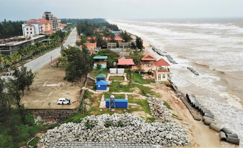
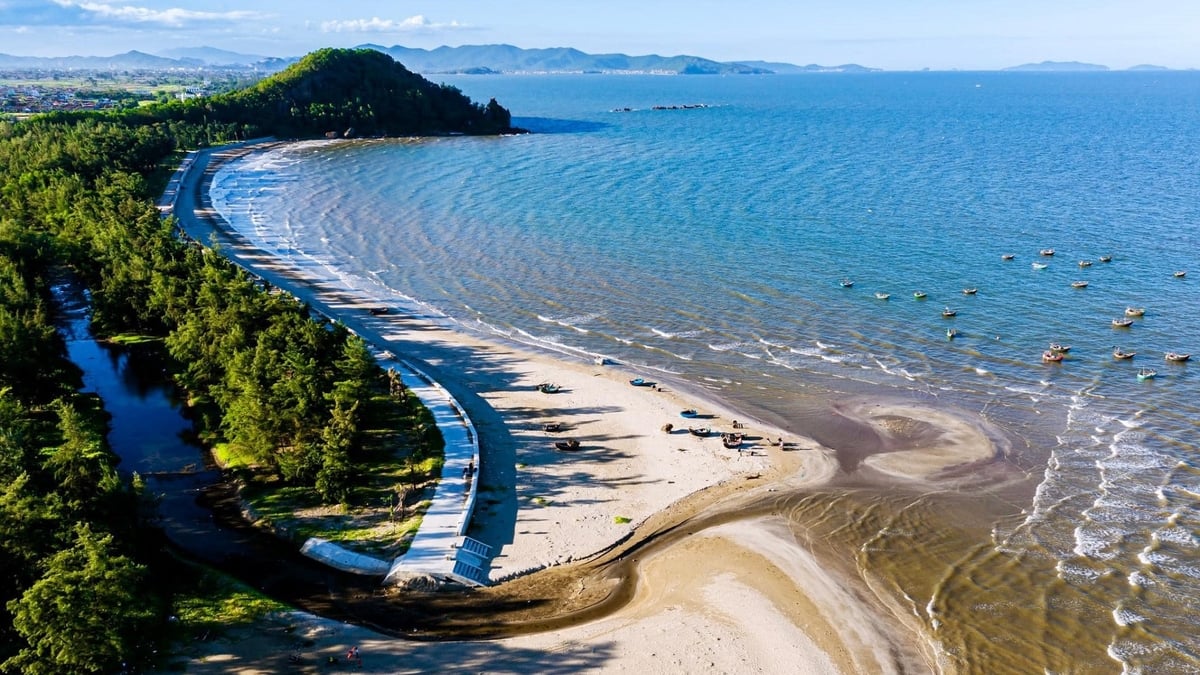
In recent years, Nhat Le beach has been frequently eroded by the sea. Quang Binh province has invested tens of billions of VND to build a Nhat Le embankment to protect and reinforce the Nhat Le coastline. However, the waves have repeatedly destroyed the embankment, and the sea has eroded the shore more and more... In the process of writing this article, contributing to finding solutions to protect Nhat Le beach, we have received many practical opinions from scientists and local government leaders.
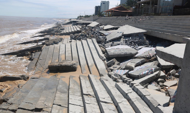
Regarding the erosion of the sea embankment at Nhat Le beach, Dong Hoi city, the Vietnam Institute of Water Resources has conducted field research and assessed the current status and causes of erosion. Through monitoring, this sea embankment has experienced many serious damage incidents. In October 2020, when the embankment was under construction in phase 1, the construction was unfinished when the waves broke and completely damaged it. After that, the contractor had to re-construct the completed embankment and requested the investor to accept it. In October 2021, after being repaired and completed, the embankment collapsed again, causing severe damage. The embankment body was cracked, broken, many large concrete slabs collapsed and lay in disarray. Since then, the embankment has not been repaired, causing the sea to encroach on the Nhat Le beach more and more.
Associate Professor, Dr. Nguyen Thanh Hung - working at the National Key Laboratory of River and Sea Dynamics under the Vietnam Institute of Water Resources, said that the Nhat Le embankment is increasingly damaged by waves, rising sea levels threaten the beauty and safety of the beach, the Vietnam Institute of Water Resources has used topographic data, geological data and meteorological and hydrological data to assess the current situation. The Vietnam Institute of Water Resources conducted a survey of the Nhat Le estuary. Surveying and measuring topography, hydrology, surveying and measuring the river cross-section of the Nhat Le river system, measuring the coastal seabed topography, collecting geology and geomorphology of the Nhat Le coastal area, measuring wave and tidal data, global wave data from NOAA... to conduct a specific and scientific assessment. After that, the Vietnam Institute of Water Resources also built a set of model tools to assess the coastline changes in Nhat Le in the form of; Analyze the erosion and deposition process for the entire Nhat Le estuary area. Analyze the erosion rate, using the NSM (m) and LRR (m/year) indexes to assess shoreline changes.
Through the results of monitoring, analysis and evaluation, according to Associate Professor, Dr. Nguyen Thanh Hung, the seabed terrain in the Nhat Le beach area tends to fluctuate significantly according to the wind and storm seasons. The northeast monsoon and storms cause strong erosion near the shore and clear offshore sedimentation, while the southwest monsoon is less volatile. The erosion trend is increasing over time. Associate Professor, Dr. Nguyen Thanh Hung proposed that the construction of a dyke on Nhat Le beach to protect the most beautiful beach in Quang Binh is necessary, but needs to be scientifically calculated because through monitoring from 2018 to 2025, the beach has seriously lowered. When there is a dyke, the coast is fixed, erosion does not encroach inside but causes the phenomenon of lowering the beach in front of the dyke, leading to a 33-34% increase in waves and a 41-44% increase in currents (currently compared to 2018). Waves higher than the dyke design by more than 2m cause damage to the dyke. The fact that Nhat Le embankment is often damaged by waves and the sea encroaches on the beach is also due to the lack of adequate assessment of hydrodynamics, bottom topography, and climate impacts during embankment construction.
In the process of finding solutions to protect Nhat Le beach, we noted the opinion of Dr. Phan Dinh Tuan, Institute of Hydraulic Engineering under the Vietnam Academy of Water Resources, proposing: In the immediate future, Quang Binh province needs to coordinate with relevant ministries and branches to urgently handle; prioritize urgent repair and reinforcement of seriously damaged sea dikes by using sloped revetments using rubble or precast concrete components. Long-term solution to protect Nhat Le beach. Accordingly, it is necessary to build an underground dike to reduce offshore waves to reduce wave energy before reaching the shore, creating conditions for the formation and stabilization of natural sandbanks, thereby increasing efficiency, protecting the shoreline, maintaining landscape value, and sustainable tourism . In the process of building the embankment to protect Nhat Le beach, it is necessary to scientifically calculate the construction of the underground dike, segmenting the dike sections, the height of the dike crest, the roof coefficient, the width of the crest, the structure to protect the surface and body of the dike, etc.
Mr. Hoang Ngoc Dan, Chairman of Dong Hoi City People's Committee affirmed: Building a sea embankment to protect Nhat Le beach is a project of strategic significance, built with the expectation of effectively responding to erosion, protecting the safety of people's lives and property, as well as essential infrastructure and developing coastal tourism in the city. However, after only a period of operation, the project has continuously suffered serious damage from historic storms in late 2020 and 2022 and 2023. Although the locality has made efforts to repair it, the sustainable stability of the embankment is still a concern, due to the lack of a thorough and long-term solution. Currently, the locality is in need of consulting experts to develop a better design and research plan to repair Nhat Le beach.
Source: https://cand.com.vn/Xa-hoi/tim-giai-phap-bao-ve-bai-bien-dep-nhat-quang-binh-khi-thuong-xuyen-bi-bi-bien-xam-thuc-i771897/


Comment (0)