
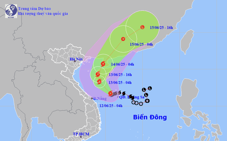
Forecast of location and direction of storm No. 1 at 10am June 12 - Photo: NCHMF
According to the National Center for Hydro-Meteorological Forecasting, at 10:00 a.m. on June 12, the center of storm No. 1 was located in the western part of the Hoang Sa archipelago. The strongest wind near the center of the storm was at level 8-9 (62-88 km/h), gusting to level 11.
Central Central region has thunderstorms, some places have rain over 300mm
Due to the influence of storm No. 1, from yesterday, especially last night to this morning, in the Central Central region there was heavy to very heavy rain and thunderstorms, the Central Highlands region had moderate rain, heavy rain and thunderstorms, locally very heavy rain in some places.
Rainfall from 7pm last night to 8am this morning was over 300mm in some places, such as Bach Ma (Hue) 551mm, Suoi Luong (Da Nang) 407mm, Dai Hiep ( Quang Nam ) 343mm...
The National Center for Hydro-Meteorological Forecasting said that because the storm is located in an area with strong east to northeast wind shear, the convective clouds are pushed westward from the storm's center.
This caused heavy to very heavy rain in the Central Central provinces, even though the storm center was in the Hoang Sa archipelago (300km from Da Nang ).
Storm No. 1 is likely to strengthen further.
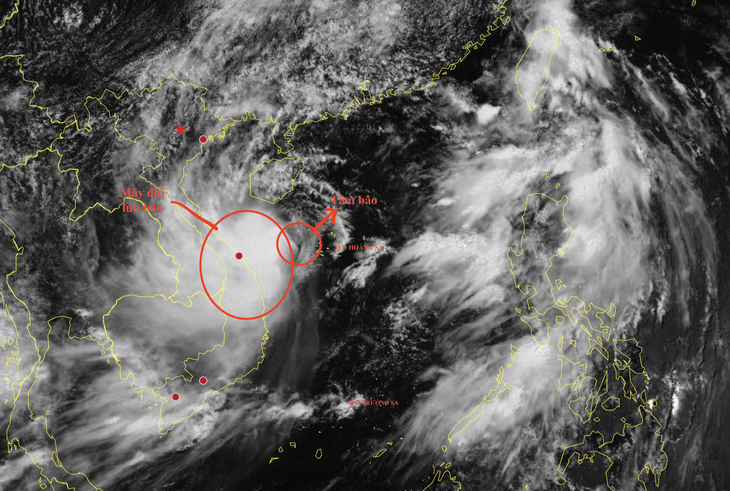
Satellite cloud images this afternoon show that the storm's convective clouds are still completely deflected to the west - Photo: NCHMF
The meteorological agency forecasts that in the next 24 hours, storm No. 1 will move mainly northwest at a speed of about 10km/h, and is likely to strengthen.
At 10am tomorrow morning, the storm center will be southwest of Hainan Island (China), with the strongest winds near the storm center at level 10, gusting to level 13.
In the next 24 - 48 hours, the storm will move north, deep into Hainan Island and towards Leizhou Peninsula (China) and gradually weaken.
At 10:00 a.m. on June 14, the storm center was on the Leizhou peninsula. The storm was currently at level 8, gusting to level 10.
The storm then moved inland into southern China and weakened into a tropical depression and then a low-pressure area.
From Hai Phong to Nghe An, beware of unusually high sea levels.
Mr. Hoang Phuc Lam - Deputy Director of the National Center for Hydro-Meteorological Forecasting - said the most notable points of storm No. 1 are strong winds at sea and heavy rain.
Accordingly, the meteorological agency warned that in the west of the northern East Sea (including the Hoang Sa archipelago), the offshore waters from Quang Tri to Quang Ngai have strong winds of level 6-8, near the storm's eye level 9-10, gusting to level 13, waves 3-5m high, near the storm's eye 4-6m.
From the night of June 12, the wind in the Gulf of Tonkin will gradually increase to level 6-7, near the storm center level 8-9, gusting to level 11, waves 2-4m high.
Due to the impact of high tides and storm surges, provinces from Hai Phong to Nghe An are likely to experience unusually high sea levels (Hon Dau 3.9m, Hon Ngu 2.8m) causing flooding in some low-lying coastal and river mouth areas between 5-7pm on June 12 and 13.
Regarding rain, Mr. Lam said that from today until June 13, the Central Central region will have heavy to very heavy rain with common rainfall from 100-200mm, locally over 350mm.
Today and tonight, the southern areas of Nghe An, Ha Tinh, the northern Central Highlands and Binh Dinh will have moderate rain, heavy rain and thunderstorms, locally very heavy rain with common rainfall from 30-80mm, locally over 150mm.
Source: https://tuoitre.vn/vi-sao-may-bao-so-1-lai-lech-hoan-toan-ve-phia-tay-khien-mien-trung-mua-rat-lon-20250612121744416.htm


![[Photo] National Assembly Chairman attends the seminar "Building and operating an international financial center and recommendations for Vietnam"](https://vphoto.vietnam.vn/thumb/1200x675/vietnam/resource/IMAGE/2025/7/28/76393436936e457db31ec84433289f72)


Comment (0)