
 |
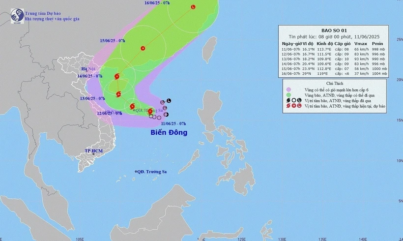
| The movement of storm No. 1, morning of June 11, 2025. Photo: VNA |
At 7:00 a.m., the center of the storm was at about 16.1 degrees north latitude; 113.7 degrees east longitude in the sea east of the Hoang Sa area.
The strongest wind near the storm center is level 8 (62-74 km/h), gusting to level 10. The storm moves slowly in a west-northwest direction at a speed of about 5-10 km/h.
Commenting specifically on the storm's developments, Associate Professor, Doctor, Director of the National Center for Hydro-Meteorological Forecasting Mai Van Khiem said that as of 7am on June 12, the storm was moving west-northwest over the Hoang Sa area at a speed of about 10 km/h and was likely to strengthen. The storm's strongest wind was level 9, gusting to level 11.
The dangerous area is identified as the northern East Sea area (including the Hoang Sa area). Natural disaster risk level 3.
As of 7:00 a.m. on June 13, the storm is moving northwestward over the southern part of Hainan Island (China) at a speed of about 5-10 km/h and is likely to strengthen. The storm's strongest wind is level 10, gusting to level 13.
The dangerous area is identified as the northern East Sea area (including Hoang Sa area), the sea area east of Bac Bo Gulf area and the offshore sea area from Quang Tri to Quang Ngai . Natural disaster risk level 3.
At 7:00 a.m. on June 14, the storm moved northward over the sea west of Leizhou Peninsula (China) at a speed of about 5-10 km/hour and gradually weakened. The storm's strongest wind was level 9, gusting to level 12.
The dangerous area is identified as the sea area west of the northern East Sea (including the Hoang Sa area), the sea area east of the Gulf of Tonkin.
Warning, from the next 72 to 120 hours, the storm will move in a north-northeast direction then change to a northeast direction at about 20km per hour.
Due to the influence of the storm, the northern East Sea (including the Hoang Sa sea area), the northern central East Sea area has thunderstorms and strong winds of level 6-7, the area near the storm's center has winds of level 8-9, gusts of level 11, waves 3-5m high, very rough seas.
In the south of the central East Sea and the southern East Sea (including the Truong Sa sea area), there will be strong southwest winds of level 6, sometimes level 7, gusting to level 8-9, waves 2-4 m high, and rough seas.
Ships operating in the above mentioned dangerous areas are susceptible to the effects of storms, whirlwinds, strong winds and large waves.
Source: https://baophuyen.vn/xa-hoi/202506/ap-thap-nhiet-doi-o-phia-dong-khu-vuc-hoang-sa-da-manh-len-thanh-bao-ab621b6/


Comment (0)