
Weather expert Nguyen Ngoc Huy said a tropical depression is currently active in the eastern coastal area of the central Philippines. On the evening of August 22, the tropical depression will move into the East Sea, then strengthen into storm No. 5.
The expert forecasts that the storm will move westward into central Vietnam. There is a high possibility that the storm will make landfall in the central region on August 24 or 25.
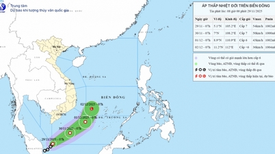
According to Mr. Huy, the exact location of the storm's landing cannot be determined at this time. People in the area from Quang Ngai to Thanh Hoa should pay attention to the updates in the next news bulletins.
Mr. Huy said that this storm is likely to create a relatively large area of rain and a very large amount of water because the sea surface is currently hot and the East wind is dominant, so a quantity of moist clouds can be pushed by the inertial pressure of the storm to the shore before the eye of the storm hits the shore.

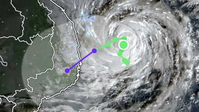
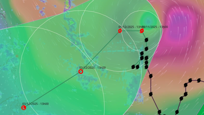
Weather monitoring application Windy predicts that a storm will form and approach the coast of the central provinces on August 24-25. Photo: Windy
Previously, on the afternoon of August 21, the National Center for Hydro-Meteorological Forecasting said that a low pressure area was active in the sea east of the Philippines.
According to forecasts in the next 24-36 hours, the low pressure area will move in the West-Northwest direction at a speed of 15-20 km/h, enter the East Sea and is likely to strengthen into a tropical depression.
After forming, the tropical depression could strengthen into a storm with a probability of 60-70% and move quickly towards the Gulf of Tonkin in the next 2-3 days, according to Mr. Huong.
Due to the influence of low pressure circulation, the tropical depression is likely to strengthen into a storm. In the coming days, the northern and central East Sea (including Hoang Sa sea area) and Bac Bo Gulf will have increasingly stronger winds and bad weather.
Ships operating in these sea areas need to proactively take precautions to ensure safety.
The Hydrometeorological Agency said that from August 25, the Northern region and the area from Thanh Hoa to Hue will likely experience moderate to heavy rain over a wide area.
According to forecasts, the development of this low pressure area is still complicated, people need to follow the next official news.
Source: https://baonghean.vn/ap-thap-nhiet-doi-vao-bien-dong-trong-hom-nay-va-co-the-manh-thanh-bao-10304916.html


![[Photo] Dan Mountain Ginseng, a precious gift from nature to Kinh Bac land](/_next/image?url=https%3A%2F%2Fvphoto.vietnam.vn%2Fthumb%2F1200x675%2Fvietnam%2Fresource%2FIMAGE%2F2025%2F11%2F30%2F1764493588163_ndo_br_anh-longform-jpg.webp&w=3840&q=75)


Comment (0)