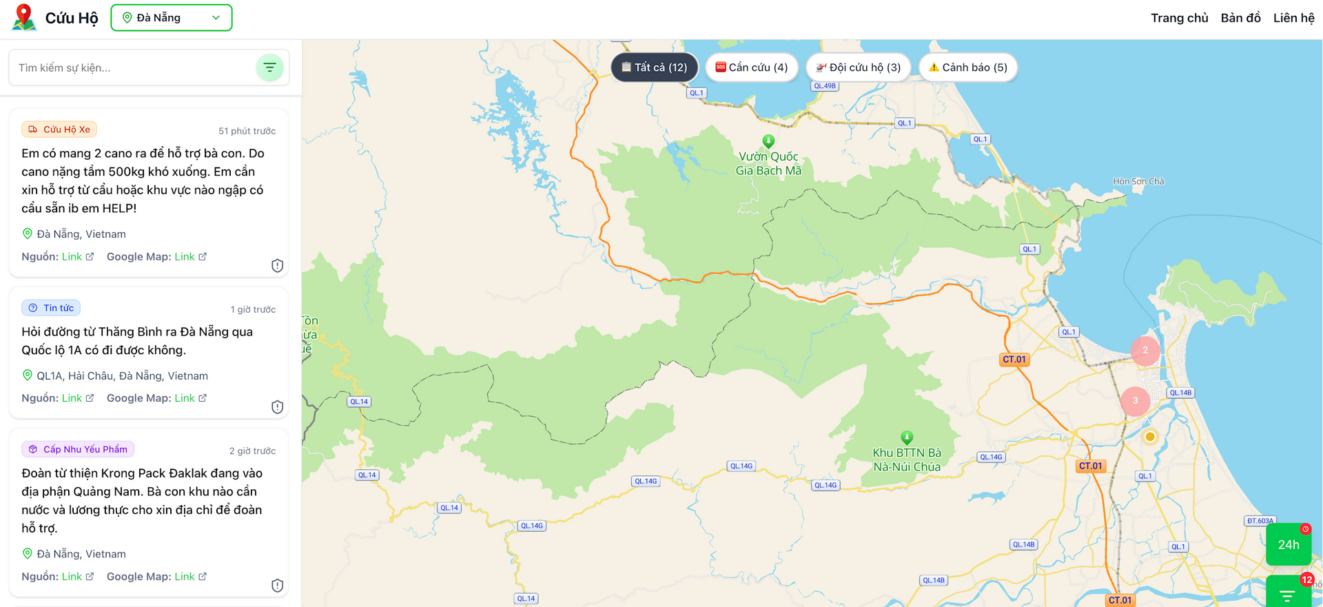
In early October, the circulation of storm Matmo caused prolonged heavy rains, causing many areas of Thai Nguyen to be deeply flooded, isolating hundreds of households. On social networks, there were many calls for help and shared locations, but the information was fragmented and overlapping, making it difficult for rescue forces to determine priority areas.
Amidst that chaotic data flow, three young people, Nguyen Thi Mai Anh (32 years old, living in Ho Chi Minh City), Tu Tat Huan (29 years old) and Dang Long (30 years old, both living in Hanoi ) came up with the idea of creating an online rescue map, helping to connect people with rescue teams.
At two ends of the country, they connected via computer screens, racing against time to send distress signals to the right rescuers. The development team took advantage of an existing data processing system from an old project, quickly rewrote the structure, built a server, and integrated AI to scan and filter distress information from social networks. Mai Anh was in charge of optimizing the data flow and calling the API; Huan was in charge of the logic and data standardization; and Long developed the map interface.
From the initial idea to the finished product took only four hours in the middle of the night. In the early morning of October 8, the thongtincuuho.org platform officially went into operation, becoming a useful rescue support tool.
Mr. Huan said that the system was built on the principle of automatic processing and visual display. The data scanning tool automatically collects articles and comments containing the keyword "cry for help". AI then analyzes and extracts important information such as address, phone number, and condition of the victim, while eliminating duplicate or incorrect content.
Valid data is displayed on the map in the form of a “heatmap”. Each point corresponds to a location that needs help, the color shows the level of urgency and the update time. Thanks to that, instead of having to read hundreds of separate posts, the rescue team only needs to open the map to see the whole flooded area, determine the priority area and quickly contact the person in need of help. People can submit information directly through the form on the website or simply leave a comment with the location on the community groups; the system will automatically collect and display it on the map.
In the first three hours after its launch, the system recorded about 4,000 visits. After 24 hours, this number increased to more than 27,000. Currently, the rescue website has about 3,000 users.
After the platform in Thai Nguyen was stable, the team started upgrading to the second version, allowing deployment in any province or city in just about 5 minutes of preparation. Each area has its own map, continuously updated with flood information and classified by level of danger, making rescue work more effective. “For technical reasons, the team uses the old administrative unit to ensure the map is as accurate as possible,” Mr. Huan shared.
Each bright spot on the map is not just data, but a sign of fragile life. The combination of expertise and community spirit has contributed to effective support for people in urgent times.
Source: https://baodanang.vn/ban-do-cuu-ho-truc-tuyen-ho-tro-nguoi-dan-vung-lu-3309568.html























![[Video] Hue Monuments reopen to welcome visitors](https://vphoto.vietnam.vn/thumb/402x226/vietnam/resource/IMAGE/2025/11/05/1762301089171_dung01-05-43-09still013-jpg.webp)




















![Dong Nai OCOP transition: [Part 2] Opening new distribution channel](https://vphoto.vietnam.vn/thumb/402x226/vietnam/resource/IMAGE/2025/11/09/1762655780766_4613-anh-1_20240803100041-nongnghiep-154608.jpeg)





Comment (0)