

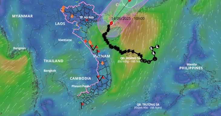
Typhoon No. 1's path - Photo: VIETNAM DISASTER MONITORING SYSTEM
Speaking to Tuoi Tre Online about the patterns of typhoons, Mr. Le Dinh Quyet - head of the forecasting department of the Southern and Central Highlands Meteorological and Hydrological Station - stated that each typhoon has a different trajectory. However, statistics from many years show that some typhoons have nearly similar trajectories.
The trajectory of a hurricane depends on many factors, including external forces and internal forces within the storm.
External factors include cold air, low-pressure troughs, and the tropical convergence zone. In particular, typhoons are highly dependent on the activity of the Western Pacific high-pressure system (subtropical high-pressure system).
This high-pressure system exists at an altitude of 3,000-5,000 meters. We can visualize this high-pressure system as a mass of high-pressure gas at its center, gradually decreasing towards the edges. Wind blows from the center outwards, and as the edges of the high-pressure system move westward, they create isobars curving in arcs or nearly elliptical shapes, with their peaks high in the west.
In many cases, subtropical high-pressure systems act as a conduit for storms. Therefore, tropical depressions and storms will follow the edge of this Western Pacific high-pressure system as they move.
According to statistics, over 90% of tropical cyclones (storms, tropical depressions) in the Pacific Ocean form from the tropical convergence zone.
The tropical convergence zone is typically formed by the northeast and southwest monsoon winds. Therefore, this pattern usually has an axis that is almost east-west, or northwest-southeast. This axis is relatively perpendicular to our country.
When a tropical depression or storm forms directly over the tropical convergence zone, it will gradually slide westward. Typically, atmospheric pressure is lower over land than over the sea, so storms and tropical depressions will head west or west-northwest.
The trajectory of movement is then influenced not only by external forces but also by internal forces such as temperature within the storm's circulation, humidity, and forces generated within the storm itself.
Regarding Typhoon No. 1, in addition to the factors analyzed above, it was also affected by the subtropical high-pressure system encroaching westward. The typhoon followed the edge of the system, so its initial trajectory was northwest. Later, it gradually bent and headed towards Hainan Island, then gradually shifted to its current direction and is trending towards Leizhou as predicted.
"The trajectory of this storm, number 1, is nothing special. It's consistent with the weather systems that are at play and suitable for operation during the typhoon season," Mr. Quyet said.
Source: https://tuoitre.vn/bao-so-1-co-bat-thuong-khong-20250614145630144.htm

![[Photo] National Assembly Chairman Tran Thanh Man inspects election preparations in Hai Phong city.](https://vphoto.vietnam.vn/thumb/1200x675/vietnam/resource/IMAGE/2026/02/26/1772095420401_ndo_br_bnd-8016-jpg.webp)


![[Photo] National Assembly Chairman Tran Thanh Man working with the Hai Phong City Election Committee](https://vphoto.vietnam.vn/thumb/1200x675/vietnam/resource/IMAGE/2026/02/26/1772103806795_ndo_br_bnd-8224-jpg.webp)
![[Photo] Thousands of tourists visit the Quang Trung Emperor Temple in Nghe An during the early spring season.](https://vphoto.vietnam.vn/thumb/1200x675/vietnam/resource/IMAGE/2026/02/26/1772095410680_img-9305-3882-jpg.webp)


Comment (0)