
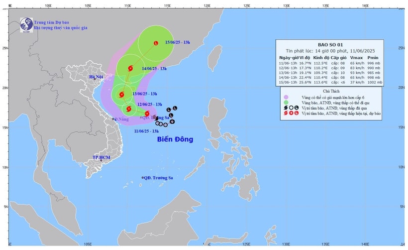
According to the National Center for Hydro-Meteorological Forecasting, at 1 p.m. today, June 11, the center of the storm was located at about 16.7 degrees North latitude - 112.5 degrees East longitude in the sea east of Hoang Sa archipelago.
The strongest wind near the storm center is level 8 (62-74km/h), gusting to level 10. The storm moves west-northwest at a speed of 10-15km/h.
This afternoon and tonight, storm No. 1 is moving west-northwest, traveling 10-15km per hour and is likely to strengthen.
At sea, in the west of the northern East Sea (including the Hoang Sa archipelago), there are strong winds of level 7-8, near the storm's eye level 9-10, gusts of level 13, waves 3-5m high, near the storm's eye 4-6m, very rough seas.
From the night of June 11, the offshore sea area from Quang Tri to Quang Ngai has winds gradually increasing to level 6-7, near the storm center level 8-9, gusting to level 11, waves 3-5m high, very rough seas.
From June 12, the sea area in the eastern part of the Gulf of Tonkin will have winds gradually increasing to level 6-7, near the storm center level 8, gusting to level 10, waves 2-4m high, rough seas.
Ships operating in the above mentioned dangerous areas are likely to be affected by storms, whirlwinds, strong winds and large waves.
Due to the influence of storm No. 1, from the afternoon of June 11 to June 13, in the Central Central region, there will be heavy to very heavy rain with common rainfall of 100-300mm, in some places over 450mm; in the northern Central Highlands, there will be moderate rain, heavy rain and thunderstorms, locally very heavy rain with common rainfall of 70-150mm, in some places over 200mm.
At 1 p.m. tomorrow, June 12, the center of storm No. 1 is at approximately 17.3 degrees North latitude - 110.2 degrees East longitude; in the sea south of Hainan Island (China). The strongest wind is level 9, gusting to level 11.
During thunderstorms, beware of tornadoes, lightning, gusts of wind, flash floods, and landslides that can be dangerous to people and cause property damage. Heavy rain and localized heavy rain can also cause flooding on some roads during the afternoon rush hour.
The meteorological agency recommends that authorities in localities affected by the storm pay attention to checking for blockages and vulnerable locations in the area to take preventive measures and respond promptly to any possible situations, ensuring safety for people.
Source: https://baoquangnam.vn/bao-so-1-di-chuyen-theo-huong-tay-tay-bac-gay-mua-lon-tai-trung-trung-bo-bac-tay-nguyen-3156548.html


Comment (0)