
Unprecedented adverse rainfall combination
According to Dr. Truong Ba Kien, Deputy Director of the Center for Meteorology and Climate Research (Institute of Hydrometeorology and Climate Change - Ministry of Agriculture and Environment ), the recent extremely heavy rain in the Central region (focusing on Hue - Da Nang) was due to the simultaneous convergence of four main weather patterns: Cold air continuously strengthening from the North, the tropical convergence zone across this area and over the low pressure area off the Central coast, disturbances in the East wind zone from low to high levels and terrain factors (wind-catching terrain of the Truong Son range and coastal slopes).
When these factors appear and interact strongly at the same time, the amount of moisture from the sea is "pushed" in and meets the terrain factor to condense, causing prolonged and extremely intense rain. In particular, this time, the combination of the above four factors takes place in the context of increasing global climate change, causing air temperature and moisture storage capacity of the air to be higher than before.
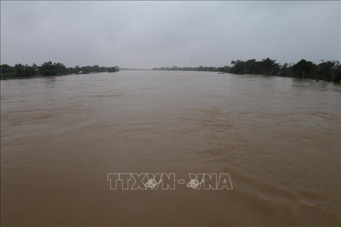
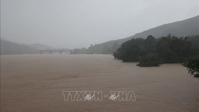
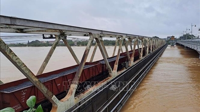
"It can be said that, along with the negative impact of climate change, it has "activated" an unprecedented adverse rain combination, breaking all previous rain records in the Central region. The recent rain recorded nearly 1,740 mm in 24 hours at Bach Ma (Hue). This figure far exceeds all data ever observed in Vietnam.
The previous highest level recorded during the historic flood in 1999 was 997 mm/day. If officially reported and confirmed by Vietnam to the World Meteorological Organization (WMO), this could become the world's largest non-storm daily rainfall record. Currently, the global 24-hour rainfall record belongs to Réunion Island (France, 1966) with 1,825 mm of rainfall caused by tropical storm Denise," Dr. Truong Ba Kien emphasized.
Dr. Truong Ba Kien said that this is not only a national record, but also the second in the world in terms of 24-hour rainfall. Notably, this rainfall is not caused by storms, but mainly comes from large-scale atmospheric convergence and terrain interactions. The rainfall of 1,740 mm/day in Hue is a concrete demonstration of the trend of climate extremization. Under the impact of climate change, not only are storms stronger, but even non-storm formations can cause record rainfall.
At the same time, as the planet warms (a 1 degree Celsius increase allows the atmosphere to hold about 7% more water vapor), there is an increase in latent energy in the atmosphere. As a result, rain systems and storms become more powerful, and the intensity of extreme rainfall is also increasing significantly.
Heavy rain concentrated in Ha Tinh - Da Nang, Khanh Hoa
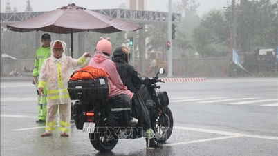
Referring to the rain situation in the coming time, Associate Professor, Doctor, Director of the National Center for Hydro-Meteorological Forecasting Mai Van Khiem said that according to the forecast of the National Center for Hydro-Meteorological Forecasting, from the evening of October 29 to October 30, the area from South Quang Tri to Da Nang city will have heavy to very heavy rain with common rainfall of 100-250mm, locally over 500mm and from the night of October 30, heavy rain is likely to gradually decrease.
From the evening of October 29 to October 31, the area from Southern Nghe An to Northern Quang Tri will have moderate to heavy rain with common rainfall of 70-150mm, locally very heavy rain over 300mm. Warning of risk of heavy rain over 150mm/3 hours.
From the evening of October 29 to the early morning of October 30, Quang Ngai province had moderate to heavy rain with rainfall of 30-60mm, locally very heavy rain over 100mm (from October 30, the rain decreased).
From now until about the first half of December 2025, moderate and heavy rains are likely to continue to appear in the Central region, concentrated in the area from Ha Tinh to Da Nang, Khanh Hoa and the eastern region of the provinces from Quang Ngai to Dak Lak.
Regarding the total rainfall in November-December 2025, Director Mai Van Khiem said that in November, in most areas across the country, it was generally 10-30% higher than the average of many years, and even higher in some places; in the Northern region, it was approximately the average of many years, except for the Northern mountainous region, which tended to be about 10-20% lower than the average of many years in the same period.
In December, total rainfall in the provinces from Quang Tri to Da Nang and the eastern region from Quang Ngai to Dak Lak was generally 250-580mm, 50-150mm higher than the average of many years. The Northern region and Thanh Hoa-Ha Tinh provinces generally had 15-40mm, with Ha Tinh alone having a total rainfall of 80-150mm, 5-10mm lower than the average of many years in the same period. Other regions had a total rainfall of 40-80mm, 10-40mm higher than the average of many years in the same period.
Regarding the rainfall trend in the first months of 2026, from February, total rainfall in the Northern region is generally from 20-40mm, higher in some places; in March, total rainfall is generally from 40-70mm. Total rainfall in April 2026 is generally 50-100mm, in the Northwest region, some places are over 110mm.
In February, total rainfall from Thanh Hoa to Hue is generally from 20-50mm; in the South Central Coast, total rainfall is generally from 50-120mm. In March, it is generally from 30-70mm, higher in some places. In April, it is generally from 50-150mm.
The Central Highlands region generally has little rain, with total rainfall generally below 10mm. The Southern region has total rainfall generally from 10-30mm, higher in some places. In March, it is generally from 30-70mm. In April, it is generally from 50-150mm.
From late February to March, the Northern region is likely to experience light rain and drizzle. From February to March, there is also a possibility of some showers and thunderstorms in the Central region. Beware of dangerous weather phenomena such as thunderstorms, tornadoes, lightning and strong gusts of wind during thunderstorms.
In the first months of 2026, there is a possibility of unseasonal rains in the Southern region.
Possibility of 1-2 storms and tropical depressions
Regarding the situation of hydrometeorological disasters from now until the end of 2025, Director of the Department of Hydrometeorology Nguyen Thuong Hien said that there are about 3 storms and tropical depressions in the East Sea; of which, about 1-2 storms are likely to affect the mainland of Vietnam. Severe cold may appear in the North from the second half of December 2025.
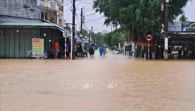
Moderate to heavy rains are likely to occur in the Central region, concentrated in the area from Ha Tinh to Da Nang, Khanh Hoa and the eastern areas of Quang Ngai and Dak Lak provinces. Meanwhile, the Northern region is less likely to experience heavy rain and floods on the Northern rivers.
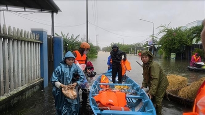
Flood peaks on rivers in the Central region are at alert level 2-3, some places exceeding alert level 3, with the risk of late floods coinciding with the reservoir storage period.
For the Mekong Delta region: Floods at Tan Chau and Chau Doc stations are gradually decreasing. From now until the end of December 2025, this area will be affected by 5 high tides on October 22-27, November 4-10, November 18-25, December 2-8 and December 17-24, of which, the high tides in early November and early December 2025 will raise the water level at downstream stations to alert level 2-3 and above alert level 3. There is a high risk of flooding and dike overflow in low-lying, coastal, riverside and outside dike areas.
In the 2025-2026 dry season in the Southern region, the salinity intrusion situation will be lower than the average of many years and lower than in 2024-2025.
The ENSO phenomenon (El Nino and La Nina) is forecasted to have a 60-75% chance of maintaining La Nina conditions in the next three months.
Director Nguyen Thuong Hien stated that in order to proactively respond promptly and effectively to ensure the safety of people's lives and minimize property damage, in the immediate future, in addition to the forecast and warning bulletins of natural disasters issued periodically according to regulations, to monitor real-time forecast and warning information of thunderstorms, tornadoes, lightning, flash floods, landslides, it is recommended that units, local authorities, people... access the warning systems of the Department of Hydrometeorology at: http://iweather.gov.vn/ and http://luquetsatlo.nchmf.gov.vn/ to update information.
Along with that, the Department directed the National Center for Hydro-Meteorological Forecasting to continue to complete and ensure the exploitation of the database fully and promptly from the Shared Data System (CDH) to serve forecasting and warning work. Monitoring data sources need to carry out the process of checking and calibrating the data quality before being put into the Shared Data System.
The Department directs the National Center for Hydro-Meteorological Forecasting and relevant units to ensure monitoring, complete and reliable collection and real-time transmission of data to serve forecasting, especially data on: Water level, flow, salinity measurement, and monitoring data of specialized stations.
The National Center for Hydro-Meteorological Forecasting will continue to coordinate research with international experts to perfect the method of processing and assimilating radar data for high-resolution forecasting combined with methods to improve the quality of ultra-short-range forecasting using new technology. In addition, it is necessary to inherit the project results in implementing the processes of data testing, calibration and data synchronization.
In the long term, regional hydrometeorological stations, provincial and municipal hydrometeorological stations will continue to coordinate with the National Center for Hydrometeorological Forecasting to update, develop and perfect models and technologies for hydrological forecasting and warning, and zoning of landslide and flash flood risks.
The Center continues to carry out new interdisciplinary research to approach post-processing and forecasting problems using big data technology and artificial intelligence specifically for the problem of forecasting dangerous weather (storm identification, storm forecasting, and extremely short-term quantitative rainfall forecasting).
Natural disasters of hydrometeorological origin are becoming more and more complex and abnormal. Therefore, to minimize the risk of damage to the lowest level, the most important and decisive thing is to strictly follow the instructions of the National Civil Defense Steering Committee, the Ministry of Agriculture and Environment, relevant ministries, branches, and local authorities before, during and after natural disasters.
Localities and people need to closely monitor and update the latest information on the website of the National Center for Hydro-Meteorological Forecasting at nchmf.gov.vn, at regional Hydro-Meteorological Stations, provincial and municipal Hydro-Meteorological Stations and on the official mass media of the Central and local levels to proactively respond.
Source: https://baotintuc.vn/van-de-quan-tam/bon-hinh-thai-thoi-tiet-hoi-tu-gay-mua-ky-luc-lich-su-tai-mien-trung-20251029173041317.htm
![[Photo] Prime Minister Pham Minh Chinh chaired a meeting to discuss solutions to overcome the consequences of floods in the central provinces.](https://vphoto.vietnam.vn/thumb/1200x675/vietnam/resource/IMAGE/2025/10/29/1761716305524_dsc-7735-jpg.webp)
![[Photo] Prime Minister Pham Minh Chinh chaired a meeting to evaluate the operation of the two-level local government model.](https://vphoto.vietnam.vn/thumb/1200x675/vietnam/resource/IMAGE/2025/10/29/1761751710674_dsc-7999-jpg.webp)
![[Photo] Human love in the flood in Hue](https://vphoto.vietnam.vn/thumb/1200x675/vietnam/resource/IMAGE/2025/10/29/1761740905727_4125427122470875256-2-jpg.webp)
![[Photo] Hue: Inside the kitchen that donates thousands of meals a day to people in flooded areas](https://vphoto.vietnam.vn/thumb/1200x675/vietnam/resource/IMAGE/2025/10/29/1761738508516_bepcomhue-jpg.webp)


![[Live] Concert Ha Long 2025: "Heritage Spirit - Brightening the Future"](https://vphoto.vietnam.vn/thumb/402x226/vietnam/resource/IMAGE/2025/10/29/1761743605124_g-anh-sang-am-thanh-hoanh-trang-cua-chuong-trinh-mang-den-trai-nghiem-dang-nho-cho-du-khach-22450328-17617424836781829598445-93-0-733-1024-crop-1761742492749383512980.jpeg)


Comment (0)