
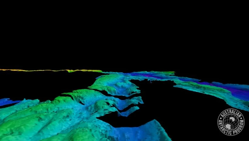
The massive underwater canyon was discovered using the sonar system of the icebreaker RSV Nuyina. (Photo: Antarctica Australia)
Australian scientists have announced the discovery of a giant new canyon on the seabed in the Antarctic region. The discovery is the basis for developing more accurate models of the interaction between Antarctic ice sheets and the ocean.
Acoustic experts on the icebreaker RSV Nuyina - a ship tasked with researching and supplying Australian research facilities in Antarctica - have just discovered a vast undersea canyon, 2,100m deep, 9,000m wide, and more than 25 nautical miles (more than 46km) long, in an area about 70km from Adams Glacier.
Scientists stumbled upon the canyon while waiting for severe weather to pass on a supply route to Australia's Casey research station in Antarctica.
Trip leader Keith Ashby said poor weather conditions, low water levels and high winds led them to head into open water and spent about 15 hours mapping the area.
Then, on its way back to Australia, the ship conducted additional surveys to “complete the picture” of this deep-sea depression.
Acoustics expert Alison Herbert and systems science engineer Tom Rushton Brumby said this was the second time they had discovered impressive underwater terrain in Antarctica using the ship's sonar system.
“This latest map of the undersea canyon adds to our initial discovery during RSV Nuyina’s maiden voyage to Casey Station two years ago, when the team mapped the nearby Vanderford Canyon, which is 2,200m deep, 2,000m wide and more than 55km long,” Herbert said.
The sonar on the RSV Nuyina provides greater depth mapping capabilities than previous technology, the expert said.
The RSV Nuyina's multi-beam sonar works by emitting fan-shaped sounds beneath the ship and "listening" for the returning echoes to build an image of the seafloor.
The seafloor map created using multibeam sonar data provides insight into the region's geological and ice age history, and allows scientists to identify notable locations to focus their research.
RSV Nuyina's chief technology officer, Lloyd Symons, said exploring and mapping the deep ice canyons was key to developing better models of how the Antarctic ice sheet and ocean interact, and that the discovery was just the beginning./.
VNA
Source


![[Photo] The 9th Congress of the Party Committee of the Office of the President, term 2025-2030](https://vphoto.vietnam.vn/thumb/1200x675/vietnam/resource/IMAGE/2025/6/20/78e7f27e8c4b4edc8859f09572409ad3)


![[Maritime News] Wan Hai Lines invests $150 million to buy 48,000 containers](https://vphoto.vietnam.vn/thumb/402x226/vietnam/resource/IMAGE/2025/6/20/c945a62aff624b4bb5c25e67e9bcc1cb)


Comment (0)