
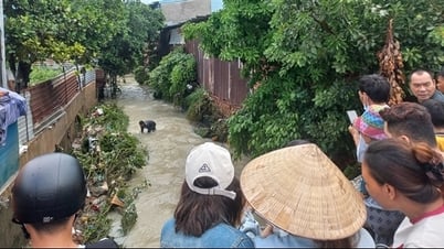
According to the Standing Office of the Civil Defense - Natural Disaster Prevention and Search and Rescue Command of Can Tho City, the landslide has a total length of 46 meters, 4 meters deep inland, of which 30 meters have completely collapsed, the remaining 16 meters are in a state of serious subsidence.

According to local residents, riverbank erosion in O Mon district has been occurring for many years, especially during the rainy season. The Can Tho City People's Committee is actively implementing solutions to limit riverbank erosion; focusing on building embankments to prevent erosion at vulnerable points and relocating households living in high-risk areas.
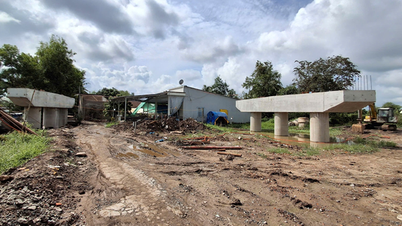
In O Mon district, on April 3, Can Tho city started the construction of an emergency embankment to prevent landslides on the O Mon river, passing through Thoi An ward, with a total estimated investment of about 130 billion VND. The project is identified as an emergency project to prevent landslides and protect the lives and property of people and the state. The embankment is 650 meters long, built according to a reinforced concrete structure, combined with stone mats to reinforce the anti-erosion roof. The expected implementation period is from 2025 to 2026, and the capital will be allocated from the city budget according to the 2025 public investment plan.
It is known that in 2024, Can Tho City had 27 landslides, causing 14 houses to collapse, 1 warehouse to collapse and affecting 35 other houses, with a total damage of over 15 billion VND. The city has issued 12 emergency construction orders to fix 12/27 dangerous landslides, with a total length of 2,105 meters, a total investment of 166.3 billion VND; at the same time, it has supported the repair of damage caused by natural disasters with a total amount of nearly 2 billion VND from the Natural Disaster Prevention Fund.
On May 14, the People's Committee of Cu Lao Dung district ( Soc Trang province) said that the situation of landslides on the left and right river dykes in the district is complicated, threatening the production and daily life of hundreds of households living inside the dyke area. Because Cu Lao Dung district is isolated from the mainland, it is surrounded by the Hau River and the East Sea. The left and right river dyke is more than 80 km long and over 2 meters high, surrounding the district; this is an important dyke line to prevent high tides from affecting people's production. Since the beginning of the year, this dyke section has had 6 landslides with a length of over 350 meters in 2 communes of An Thanh Dong and Dai An 1. Of which, 4 are serious landslides with a length of over 250 meters, threatening people's daily life and production.
Mr. Nguyen Van Dac, Head of the Department of Agriculture and Environment of Cu Lao Dung district, said that some landslides encroached on the foot of the dike by 1 meter, the bottom by 4 meters and the depth by 2.5 meters, some landslides were 1.5 meters deep into the rural road and some landslides also had cracks encroaching more than 100 meters inland. Currently, 6 landslide sections have 255 households living, with an agricultural land area of over 365 hectares. As soon as the landslide occurred, the locality mobilized forces to temporarily reinforce the landslide; put up ropes and warning signs to ensure that vehicles and people can safely pass through the landslide.
Previously, in mid-March 2025, in Bac Lieu province, a landslide occurred on the west bank of the 30/4 canal, downstream of Nha Mat sluice (Nha Mat ward, Bac Lieu city). The landslide was 33 meters long, 3 meters wide, and about 1.3 meters deep. The landslide was determined to be caused by erosion from the strong current from the East Sea and the influence of the tide. Currently, cracks have appeared near the landslide area, and there is a risk of further landslides if not reinforced promptly. The authorities reinforced the canal bank by placing rows of Melaleuca piles on the outside, then using soil sacks or sand sacks to rebuild the canal roof, reinforcing the layer of stone gabions above within the landslide area, to ensure temporary stability for the landslide area; speed up the repair of the Nha Mat sluice cylinder system to soon open the two Nha Mat sluice gates at the same time; In the long term, it is necessary to soon invest in a hard embankment system to protect the entire area and ensure long-term stability for residents...
In recent years, the rate of landslides and subsidence of riverbanks and coastlines in the Mekong Delta has been alarming. According to the Southern Institute of Water Resources Research (Ministry of Agriculture and Environment), of the 743 landslides, there are nearly 690 riverbank landslides with a total length of nearly 600 km and 53 coastal landslides with a length of more than 200 km; in particular, there are 168 particularly dangerous landslides and more than 200 dangerous landslides. Statistics from the Southern Institute of Water Resources Research also show that in the period of 2022 - 2023, the Mekong Delta region has nearly 22 million m3 of eroded riverbed sand, but the amount of sedimentation is only nearly 5 million m3, a shortage of nearly 17 million m3. Regarding the coast, in the period of 2020 - 2023, the Southwest region has over 400 km of eroded coastline, causing the loss of more than 458 hectares of land.
According to the forecast of the Southern Institute of Water Resources, natural disasters in this region will be more complicated and unpredictable, especially in terms of subsidence, landslides, flooding, saltwater intrusion, etc.
According to the Department of Dyke Management and Natural Disaster Prevention (Ministry of Agriculture and Environment), in order to respond to subsidence and landslides in the Mekong Delta, it is necessary to synchronously implement solutions of "3 no, 1 restriction". That is, do not build or upgrade houses close to river banks and on riverbeds and canals; do not illegally exploit sand on rivers; do not cut down coastal mangrove forests. Regarding restrictions, it is necessary to limit water transport vehicles traveling at high speed on rivers, creating large waves that impact the shore and cause landslides. In addition, people need to closely monitor signs of landslides such as cracks and subsidence on riverside roads and house walls, comply with the instructions of local authorities and proactively evacuate to a safe place...
Source: https://cand.com.vn/doi-song/chau-tho-cuu-long-voi-noi-lo-sat-lo-mua-mua-lu-i768382/
![[Photo] Welcoming ceremony for Prime Minister Pham Minh Chinh and his wife on an official visit to Malaysia](https://vphoto.vietnam.vn/thumb/1200x675/vietnam/resource/IMAGE/2025/5/25/dc30203c3ae24da3990266ec3b29bb2d)

![[PHOTO] Hanoi fences off demolition of "Shark Jaws" building](https://vphoto.vietnam.vn/thumb/1200x675/vietnam/resource/IMAGE/2025/5/25/1b42fe53b9574eb88f9eafd9642b5b45)
![[Photo] Ea Yieng commune settlement project abandoned](https://vphoto.vietnam.vn/thumb/1200x675/vietnam/resource/IMAGE/2025/5/25/57a8177361c24ee9885b5de1b9990b0e)
![[Photo] Funeral of former President Tran Duc Luong in Quang Ngai](https://vphoto.vietnam.vn/thumb/1200x675/vietnam/resource/IMAGE/2025/5/25/ccf19a3d8ea7450bb9afe81731b80995)
![[Photo] French President Emmanuel Macron and his wife begin state visit to Vietnam](https://vphoto.vietnam.vn/thumb/1200x675/vietnam/resource/IMAGE/2025/5/25/03b59c7613144a35ba0f241ded642a59)


Comment (0)