
At 4:00 a.m. on July 18, the center of storm No. 1 was at about 21.4 degrees North latitude; 109.3 degrees East longitude, in the northeastern area of the Gulf of Tonkin, about 140km East Southeast of Mong Cai.
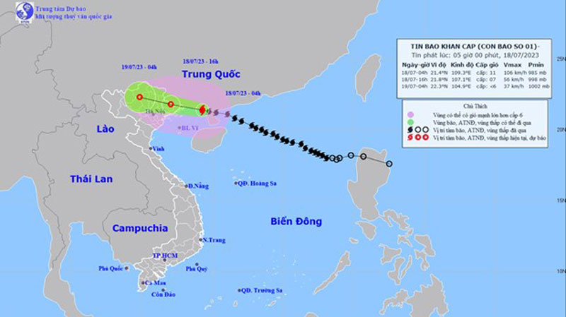 |
| Location and path of storm No. 1. (Source: National Center for Hydro-Meteorological Forecasting) |
According to the National Center for Hydro-Meteorological Forecasting, at 4:00 a.m. on July 18, the center of storm No. 1 was located at about 21.4 degrees North latitude; 109.3 degrees East longitude, in the northeastern area of the Gulf of Tonkin, about 140km East Southeast of Mong Cai ( Quang Ninh ). The strongest wind near the center of the storm was level 10-11 (89-117km/h), gusting to level 14.
At 4:00 p.m. on July 18, storm No. 1 moved in a West-Northwest direction, traveling about 20km per hour and gradually weakening.
The center of storm No. 1 is located at about 21.8 degrees North latitude; 107.1 degrees East longitude in the mainland of the Northeastern provinces of the North. The strongest wind near the center of the storm is level 7, gusting to level 9.
At around 4am on July 19, storm No. 1 moved in a West-Northwest direction, traveling about 20-25km per hour, moving inland, continuing to weaken and gradually dissipate.
The center of storm No. 1 is located at about 22.3 degrees North latitude; 104.9 degrees East longitude on the mainland of the Northern mountainous region. The strongest wind near the center of the storm is level 6.
Due to the influence of storm No. 1, on July 18, the northern area of Bac Bo Gulf (including Bach Long Vy and Co To island districts) had strong winds of level 6-7, then increased to level 8-9, near the storm center level 10-11, gusting to level 13-14. The sea was very rough.
On land, coastal areas from Quang Ninh and Hai Phong will have winds gradually increasing to level 6-7, near the storm center level 8-9, gusting to level 11; in Lang Son, Bac Giang and Thai Binh provinces, winds will gust to level 8.
The northern sea area of the North East Sea has waves 3-5m high. The Gulf of Tonkin has increasing waves, 2-4m high.
Coastal areas of Quang Ninh - Thai Binh provinces have waves 2-3m high.
Coastal areas of Quang Ninh - Hai Phong provinces have storm surges of 0.3-0.5m. Risk of flooding in low-lying coastal areas, river mouths, and coastal erosion due to the combined impact of high tides, big waves, and storm surges on the afternoon of July 18.
The National Center for Hydro-Meteorological Forecasting said that from July 18-19, the Northeast and Viet Bac regions will have heavy to very heavy rain with common rainfall of 200-300mm, locally over 350mm; the Northwest and the Northern Delta regions will have heavy rain with total rainfall of 100-200mm, Thanh Hoa and Nghe An will have moderate to heavy rain, some places will have very heavy rain with common rainfall of 70-120mm. Beware of heavy rain causing urban flooding.
The National Center for Hydro-Meteorological Forecasting also warns of a high risk of flash floods and landslides in the provinces of Quang Ninh, Lang Son, Cao Bang, Ha Giang, Lao Cai, and Yen Bai. Beware of the risk of thunderstorms, tornadoes, and strong gusts of wind in the storm's circulation area, both before and during the storm's landfall.
Meteorological experts warn that thunderstorms accompanied by tornadoes, lightning, hail and strong winds can affect agricultural production, cause trees to fall, damage houses, traffic works and infrastructure.
In addition, due to the influence of cold air, all ships and other activities in the above sea areas are at high risk of being affected by strong winds and high waves.
Forecast for day and night of July 18: Northwest region is cloudy, afternoon and night there will be moderate rain, heavy rain and thunderstorms. North to Northwest wind gradually increases to level 3-4. Lowest temperature 22-25 degrees Celsius, some places below 22 degrees Celsius. Highest temperature 29-32 degrees Celsius, some places above 32 degrees Celsius.
The Northeast region is cloudy with moderate to heavy rain, some places with very heavy rain and thunderstorms. The North to Northwest wind gradually increases to level 4-5; in the coastal areas of Quang Ninh and Hai Phong, the wind gradually increases to level 6-7, near the storm center, level 8-9, gusting to level 11.
In Lang Son, Bac Giang, and Thai Binh provinces, the wind gradually increases to level 6, gusting to level 8. The lowest temperature is 22-25 degrees Celsius, in some places below 22 degrees Celsius. The highest temperature is 27-30 degrees Celsius.
Hanoi capital is cloudy, with moderate rain, heavy rain, some places with very heavy rain and thunderstorms. North to Northwest wind gradually increases to level 4-5. Lowest temperature 24-26 degrees Celsius. Highest temperature 28-30 degrees Celsius.
Provinces from Thanh Hoa to Thua Thien - Hue are cloudy, with scattered showers and thunderstorms, locally heavy rain; in Thanh Hoa - Nghe An area, there will be moderate rain, heavy rain and thunderstorms; in thunderstorms, there is a possibility of tornadoes, lightning and strong gusts of wind. West to Southwest wind level 3. Lowest temperature 25-28 degrees Celsius. Highest temperature 30-33 degrees Celsius, some places in the South are over 33 degrees Celsius.
Provinces and cities from Da Nang to Binh Thuan have clouds, sunny days, hot in some places, showers and thunderstorms in the evening and at night in some places; in thunderstorms there is a possibility of tornadoes, lightning and strong gusts of wind. Southwest wind level 3. Lowest temperature 25-28 degrees Celsius. Highest temperature 32-35 degrees Celsius, some places over 35 degrees Celsius.
The Central Highlands and the South are cloudy, with moderate to heavy rain in the afternoon and at night, and very heavy rain in some places, with scattered thunderstorms; there is a possibility of tornadoes, lightning, and strong gusts of wind during thunderstorms. Southwest wind level 3. The Central Highlands has the lowest temperature of 20-23 degrees Celsius; the highest of 26-29 degrees Celsius. The South has the lowest temperature of 23-26 degrees Celsius; the highest of 30-33 degrees Celsius.
Source link
![[Photo] President Luong Cuong receives Vice President of the Cambodian People's Party Men Sam An](https://vphoto.vietnam.vn/thumb/1200x675/vietnam/resource/IMAGE/2025/5/25/6f327406164b403a8e36e8ce9d3b2ad2)


![[Photo] Prime Minister Pham Minh Chinh meets the Vietnamese community in Malaysia](https://vphoto.vietnam.vn/thumb/1200x675/vietnam/resource/IMAGE/2025/5/25/1f11d1256d7745a2a22cc65781f53fdc)
![[Photo] Memorial service for former President Tran Duc Luong in Ho Chi Minh City](https://vphoto.vietnam.vn/thumb/1200x675/vietnam/resource/IMAGE/2025/5/25/c3eb4210a5f24b6493780548c00e59a1)
![[Photo] President Luong Cuong receives Lao Vice President Pany Yathotou](https://vphoto.vietnam.vn/thumb/1200x675/vietnam/resource/IMAGE/2025/5/25/958c0c66375f48269e277c8e1e7f1545)


Comment (0)