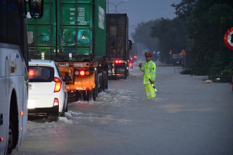
Da Nang Traffic Police work all night to regulate traffic on National Highway 1A
The North-South Expressway is congested in Hue.
According to the report of Hue City People's Committee, until the morning of October 29, La Son - Tuy Loan Expressway is still congested due to the impact of prolonged heavy rain. Currently, at Km 12+300, the positive slope has collapsed, rocks and soil have flowed onto the road surface causing local congestion, water continues to flow over the road surface, making traffic difficult.
Authorities have directed vehicles to follow Highway 1, starting from La Son intersection, to ensure traffic safety and reduce congestion along the entire route.
Ho Chi Minh Road, La Son - Tuy Loan section through Hue City, is currently experiencing landslides at some positive slopes at Km8 and rocks and soil overflowing at Km 12+300 and Km14, causing traffic jams and making it impossible for vehicles to move. The authorities have implemented traffic diversion as follows:
Vehicles traveling on the Cam Lo - La Son expressway in the North - South direction, when reaching the intersection at Km 101+200, turn down to move to Km 848+875 of National Highway 1 in La Son and continue moving to the South and vice versa; vehicles are not allowed to travel on the Ho Chi Minh road section La Son - Tuy Loan during the time of troubleshooting.
On National Highway 1 from Quang Tri to Da Nang City, flood water has gradually receded, vehicles can move normally in two directions: National Highway 1 - Hue bypass; or go to Cam Lo - La Son Expressway, then turn down at the end of the route to move to National Highway 1 at La Son intersection, continue the journey to Da Nang and vice versa.
National Highway 1A through Da Nang cannot be opened yet.
In Da Nang, heavy rain continues, causing many areas to be deeply flooded, traffic to be cut off, and the risk of floods and landslides continues to increase.
National Highway 1A through Da Nang has 6 traffic congestion points. Of these, 3 points have receded but the route is still not open, including: section Km 943+800 - Km 944+300; section Km 958+600 - Km 961+350 (new Ba Ren bridge bypass) and section Km 958+600 - Km 958+700 (old Ba Ren bridge bypass).
In addition, 3 other sections of the road are still heavily flooded. Specifically, at Km 978+300 National Highway 1, the water is 40-50cm deep, causing traffic jams; at Km 978+550 National Highway 1, the water is 30-40cm deep; at Km 941+00 National Highway 1, the water is 30-40cm deep.
Currently, National Highway QLDB III is coordinating with the Traffic Police to prohibit vehicles from passing through flooded areas, regulate and divert traffic at the above points to ensure safety for people and vehicles.
According to the report of Road Management Area III (Vietnam Road Administration), Ho Chi Minh Road through Da Nang City has 18 locations with one lane open to traffic. However, as of noon today (October 29), there are still 4 locations that are congested and cannot be opened to traffic.
Due to the extremely heavy and continuous rain, the slope at Km 1407+800 - Km 1407+950 of Ho Chi Minh road is still collapsing, traffic is completely blocked, units are still on duty at the scene and making efforts to clear the landslide, striving to reopen the road as soon as possible.
Vehicles from the North and Central regions traveling to the Central Highlands must follow National Highway 1 or the expressway to Quang Ngai, follow National Highway 24 to Kon Tum ward (Quang Ngai), or follow Ba Ri Intersection (Gia Lai) to Pleiku ward (Gia Lai).
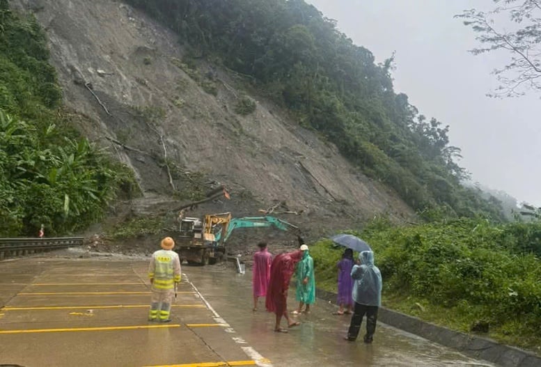
The number of landslides is increasing, many national highways continue to be congested.
Currently, the West branch of Ho Chi Minh Highway through Hue City and National Highway 49 managed by the Hue City Department of Construction are experiencing more flooding and landslides causing traffic jams.
Road Management Office II.5 has directed forces to divert and guide traffic from a distance on the West branch of Ho Chi Minh Road, north of Dakrong Bridge (Quang Tri Province), towards National Highway 9, not going through Dakrong Bridge, because there are many landslides and flooding points on the route due to heavy rain and floods.
The Ho Chi Minh Road West branch through Hue City, the section from Km313 to Km372 (A Roang) is now open to traffic, vehicles should be careful when moving on the route. The section from Km372 to Km413 is currently congested. National Highway 49A from Hue City center to A Luoi has landslides at many points, forces are working to clear a section of road to ensure traffic from Hue - A Luoi direction.
National Highway 49 section through Binh Dien commune (Hue) has 2 landslides and the section through A Luoi 3 commune is also eroding. Km 23+800 of National Highway 49 section from Cham to Tuan bridge (Thuy Xuan ward) has a negative slope landslide towards the bank of Huong river, with risk of further landslides; the force has put up warning signs of narrow roads, allowing vehicles to travel in one lane.
Phan Trang
Source: https://baochinhphu.vn/phuong-an-di-chuyen-khi-quoc-lo-cao-toc-qua-mien-trung-tac-nghen-do-mua-lu-102251029151747829.htm


![[Photo] Prime Minister Pham Minh Chinh chaired a meeting to discuss solutions to overcome the consequences of floods in the central provinces.](https://vphoto.vietnam.vn/thumb/1200x675/vietnam/resource/IMAGE/2025/10/29/1761716305524_dsc-7735-jpg.webp)
![[Photo] Human love in the flood in Hue](https://vphoto.vietnam.vn/thumb/1200x675/vietnam/resource/IMAGE/2025/10/29/1761740905727_4125427122470875256-2-jpg.webp)
![[Photo] Prime Minister Pham Minh Chinh chaired a meeting to evaluate the operation of the two-level local government model.](https://vphoto.vietnam.vn/thumb/1200x675/vietnam/resource/IMAGE/2025/10/29/1761751710674_dsc-7999-jpg.webp)

![[Photo] Hue: Inside the kitchen that donates thousands of meals a day to people in flooded areas](https://vphoto.vietnam.vn/thumb/1200x675/vietnam/resource/IMAGE/2025/10/29/1761738508516_bepcomhue-jpg.webp)























![[Live] Concert Ha Long 2025: "Heritage Spirit - Brightening the Future"](https://vphoto.vietnam.vn/thumb/402x226/vietnam/resource/IMAGE/2025/10/29/1761743605124_g-anh-sang-am-thanh-hoanh-trang-cua-chuong-trinh-mang-den-trai-nghiem-dang-nho-cho-du-khach-22450328-17617424836781829598445-93-0-733-1024-crop-1761742492749383512980.jpeg)




Comment (0)