

Gia Lai, Dak Lak and Khanh Hoa have places with rain over 100mm
Specifically, the common accumulated rainfall is as follows: Gia Lai , Dak Lak and Khanh Hoa 30-70mm, some places over 100mm; Quang Ngai and Lam Dong 20-50mm, some places over 80mm. Warning of the risk of flash floods on small rivers and streams, landslides on steep slopes in many communes/wards: Ba To, Khanh Cuong, Sa Huynh; Ba Dinh, Ba Dong, Ba To, Ba Vi, Ba Vinh, Ba Xa, Binh Minh, Binh Son, Dang Thuy Tram, Kon Plong, Lan Phong, Mang Den, Minh Long, Mo Duc, Nguyen Nghiem, Duc Pho, Tra Cau, Son Linh, Tay Tra, Tay Tra Bong, Thanh Bong, Thien Tin, Tra Bong (Quang Ngai province).
In Gia Lai province, there are communes and wards at risk of flash floods and landslides including: An Hao, An Hoa, Dak Song, Hoai Nhon Bac, Xuan An; Al Ba, An Lao, An Luong, An Nhon Tay, An Toan, An Tuong, An Vinh, Ayun, Binh An, Binh Duong, Binh Hiep, Binh Khe, Binh Phu, Bo Ngoong, Canh Lien, Canh Vinh, Cat Tien, Cho Long, Chu A Thai, Chu Krey, Chu Puh, Chu Se, Cuu An, Dak Doa, Dak Po, Dak Rong, Dak Somei, De Gi, Hoa Hoi, Hoai An, Hoi Son, Hra, Ia Bang, Ia Boong, Ia Dreh, Ia Hiao, Ia Hru, Ia Ko, Ia Le, Ia Pa, Ia Pia, Ia RSai, Ia Sao, Ia Tor, Ia Tul, KBang, KDang, Kim Son, Kon Chieng, Kong Bo La, Kong Chro, Krong, Lo Pang, Mang Yang, Ngo May, An Binh, An Khe, An Nhon, An Nhon Bac, An Nhon Dong, An Nhon Nam, Binh Dinh, Bong Son, Hoai Nhon, Hoai Nhon Dong, Hoai Nhon Nam, Hoai Nhon Tay, Quy Nhon, Quy Nhon Bac, Quy Nhon Dong, Quy Nhon Nam, Quy Nhon Tay, Tam Quan, Phu Cat, Phu My, Phu My Bac, Phu My Dong, Phu My Nam, Phu My Tay, Phu Thien, Phu Tuc, Po To, Son Lang, Sro, Tay Son, To Tung, Tuy Phuoc, Tuy Phuoc Bac, Tuy Phuoc Dong, Tuy Phuoc Tay, Uar, Van Canh, Van Duc, Vinh Quang, Vinh Son, Vinh Thanh, Vinh Thinh, Ya Hoi, Ya Ma.
For Dak Lak province, there are communes and wards at risk of flash floods and landslides including: Hoa Xuan; Dong Xuan, Hoa My, Hoa Thinh, Binh Kien, Dong Hoa, Song Cau, Tuy Hoa, Xuan Dai, Phu Hoa 1, Phu Hoa 2, Son Hoa, Son Thanh, Tuy An Bac, Tuy An Nam, Tuy An Tay, Van Hoa, Xuan Canh, Xuan Lanh, Xuan Loc, Xuan Tho; Cu Prao, Cu Pui, Cu Yang, Dak Lieng, Dak Phoi, Dang Kang, Dray Bhăng, Duc Binh, Dur KMăl, Ea Ba, Ea Knop, Ea Ktur, Ea Ly, Ea Na, Ea Ning, Ea Ô, Ea Păl, Ea Rieng, Ea Trang, Hoa Phu, Hoa Son, Krong A, Krong Ana, Krong Bong, Krong Buk, Krong No, Lien Son Lak, M'Drắk, Nam Ka, O Loan, Phu Mo, Song Hinh, Suoi Trai, Tan Tien, Tay Son, Xuan Phuoc, Yang Mao.
Along with that, Khanh Hoa province has communes and wards at risk of flash floods and landslides including: Dai Lanh, Tu Bong; Anh Dung, Bac Ai, Bac Ai Dong, Bac Ai Tay, Lam Son, My Son, Nam Khanh Vinh, Ninh Phuoc, Ninh Son, Bac Cam Ranh, Do Vinh, Phuoc Ha, Phuoc Hau, Phuoc Huu, Thuan Nam, Van Hung, Van Ninh, Van Thang.
In addition, Lam Dong province has communes and wards at risk of flash floods and landslides including: Cu Jut, Dak Mil, Dak Wil, Dam Rong 1, Dam Rong 2, Dam Rong 3, Dam Rong 4, Dinh Van Lam Ha, Don Duong, D'Ran, Duc Trong, Hiep Thanh, Ka Do, Krong No, Lac Duong, Nam Ban Lam Ha, Nam Da, Nam Dong, Nam Ha Lam Ha, Ninh Gia, Bac Gia Nghia, Cam Ly - Da Lat, Lam Vien - Da Lat, Lang Biang - Da Lat, Xuan Huong - Da Lat, Xuan Truong - Da Lat, Phu Son Lam Ha, Phuc Tho Lam Ha, Quang Hoa, Quang Lap, Quang Phu, Quang Son, Ta Dung, Ta Hine, Ta Nang, Tan Ha Lam Ha, Tan Hoi
Warning level of natural disaster risk due to flash floods, landslides, land subsidence due to heavy rain or level 1 flow.
Flood warning on rivers from Quang Tri to Lam Dong
According to the National Center for Hydro-Meteorological Forecasting, from the evening of November 6 to November 9, there is a possibility of a flood occurring on rivers from Quang Tri to Lam Dong. During this flood, the flood peak on the Bo River, Huong River (Hue City); Vu Gia - Thu Bon River (Da Nang City); Tra Khuc River, Ve River, Se San River (Quang Ngai); Kon River (Gia Lai); Ba River, Ky Lo River, Srepok River (Dak Lak) will rise to alert level 2 - alert level 3 and above alert level 3; Kien Giang River (Quang Tri); An Lao River, Lai Giang River (Gia Lai); Dinh Ninh Hoa River (Khanh Hoa), rivers in Lam Dong will rise above alert level 2; Gianh River, Thach Han River (Quang Tri), Cai Nha Trang River (Khanh Hoa) will rise above alert level 1.
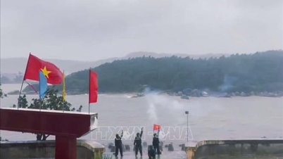
Risk of flooding in low-lying areas along rivers, urban areas, and residential areas in provinces/cities from Quang Tri to Lam Dong. High risk of flash floods on rivers and streams and landslides on slopes in provinces/cities from Quang Tri to Lam Dong (real-time warning information on flash flood and landslide risks is provided online on the website of the Department of Hydrometeorology at: https://luquetsatlo.nchmf.gov.vn and in flash flood and landslide warning bulletins).
Flood disaster risk warning level 3.
Weather in different regions on the night of November 6 and November 7
In the Northwest, there will be rain in some places at night; scattered showers and thunderstorms during the day; cold at night and in the morning, and freezing in some places. Light wind. Lowest temperature 18-21 degrees Celsius, in some places below 17 degrees Celsius. Highest temperature 23-26 degrees Celsius, in some places above 27 degrees Celsius.
In the Northeast, there will be rain in some places at night; scattered showers and thunderstorms during the day; in the plains, there will be rain, moderate rain and thunderstorms, locally heavy rain, cold at night and morning, and cold in mountainous areas. North to Northwest wind level 2-3. Lowest temperature 19-22 degrees Celsius, in mountainous areas below 18 degrees Celsius. Highest temperature 23-26 degrees Celsius.
Hanoi city sometimes has rain, showers and thunderstorms, cold at night and morning. North to Northwest wind level 2-3. Lowest temperature 20-22 degrees Celsius. Highest temperature 23-25 degrees Celsius.
Provinces and cities from Thanh Hoa to Hue, in the North, there will be scattered rain and thunderstorms at night, moderate rain, heavy rain, and locally very heavy rain in some places during the day; in the South, there will be heavy to very heavy rain, with the possibility of tornadoes, lightning, and strong gusts of wind during thunderstorms. The wind will gradually increase to level 6-7, gusting to level 8-9, and it will be cold at night and in the morning. North to Northwest wind level 3. Lowest temperature 19-22 degrees Celsius. Highest temperature in the North 22-25 degrees Celsius, in the South 25-28 degrees Celsius.
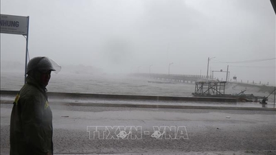
The South Central Coast has heavy to very heavy rain, with the possibility of tornadoes, lightning and strong gusts of wind in thunderstorms. Winds gradually increase to level 6-7, then increase to level 8-9, near the storm center level 10-13, gusting to level 15-16. Lowest temperature 22-25 degrees Celsius. Highest temperature 26-29 degrees Celsius, some places above 29 degrees Celsius.
Central Highlands, heavy to very heavy rain, thunderstorms with possibility of tornadoes, lightning and strong gusts of wind. Northwest wind level 3-4, especially in the North from evening the wind will gradually increase to level 6-7, near the storm center level 8-9, gusts level 11. Lowest temperature 18-21 degrees Celsius. Highest temperature 24-27 degrees Celsius.
The South has scattered showers and thunderstorms; in the afternoon and evening there are scattered showers and thunderstorms, locally heavy rain, with the possibility of tornadoes, lightning and strong gusts of wind in thunderstorms. Southwest wind level 3-4. Lowest temperature 23-26 degrees Celsius. Highest temperature 28-31 degrees Celsius, some places above 31 degrees Celsius.
Ho Chi Minh City has scattered showers and thunderstorms; in the afternoon and evening there are scattered showers and thunderstorms, locally heavy rain, with the possibility of tornadoes, lightning and strong gusts of wind during thunderstorms. Southwest wind level 3-4. Lowest temperature 23-25 degrees Celsius. Highest temperature 28-30 degrees Celsius.
Source: https://baotintuc.vn/xa-hoi/thoi-tiet-dem-611-mua-lon-tu-quang-ngai-den-lam-dong-canh-bao-lu-quet-va-sat-lo-dat-20251106172341929.htm


![[Photo] Prime Minister Pham Minh Chinh receives the delegation of the Semiconductor Manufacturing International (SEMI)](https://vphoto.vietnam.vn/thumb/1200x675/vietnam/resource/IMAGE/2025/11/06/1762434628831_dsc-0219-jpg.webp)


![Building a 'fortress' against natural disasters: [Part 2] Changing state from passive to active](https://vphoto.vietnam.vn/thumb/402x226/vietnam/resource/IMAGE/2025/11/06/1762423529917_0242-2223-160125_902.jpeg)


Comment (0)