
Forecast by 7:00 p.m. on November 6, storm No. 13 is located at about 13.7 degrees North latitude, 110.3 degrees East longitude; about 120km East Southeast of Quy Nhon ( Gia Lai ), intensity level 14, gust level 17. Due to the influence of the storm, the central area of the East Sea (including the sea area north of Truong Sa special zone - Vietnam) will have strong winds of level 8-11; the area near the eye of the storm will have strong winds of level 12-14, gust level 17, waves 5-7m high, the area near the eye of the storm will have high winds of 8-10m; the sea will be very rough.
From the morning of November 6, the sea area from South Quang Tri to Khanh Hoa (including Ly Son special zone, Cu Lao Cham island) will have winds gradually increasing to level 6-7, then increasing to level 8-11, waves 3-5m high; the area near the storm center will have winds of level 12-14, gusts of level 17, waves 6-8m high; the sea will be very rough.
From the evening of November 6, on the mainland along the coast from South Quang Tri to Da Nang City, the eastern part of the provinces from Quang Ngai to Dak Lak, the wind will gradually increase to level 6-7, then increase to level 8-9, the area near the storm's center will be level 10-12 (focusing on the eastern part of Quang Ngai - Dak Lak provinces, gusting to level 14-15).
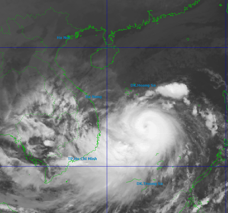
From the evening and night of November 6, in the West of the provinces from Quang Ngai to Dak Lak, the northern area of Khanh Hoa province, the wind will gradually increase to level 6-7, the area near the storm center will be level 8-9, gusting to level 11. From November 6 and 7, the area from Da Nang to Dak Lak will have very heavy rain with common rainfall of 200-400mm/period, locally over 600mm/period; the area from South Quang Tri to Hue City, Khanh Hoa and Lam Dong will have heavy rain with common rainfall of 150-300mm/period, locally over 450mm/period. On November 7 and 8, the area from North Quang Tri to Thanh Hoa will have moderate to heavy rain with common rainfall of 50-150mm/period.
Weather forecast regions across the country today (November 6):
Northwest: Cloudy, rain in some places, noon and afternoon less cloudy, sunny; light wind; early morning cold; temperature 16-27 degrees Celsius
Northeast: Cloudy, rain in some places, noon and afternoon less cloudy, sunny; North to Northeast wind level 2-3; early morning cold; temperature 16-27 degrees Celsius
Hanoi: Cloudy, no rain; sunny in the afternoon; North to Northeast wind level 2-3; cold at night and early morning; temperature 19-27 degrees Celsius.
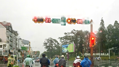
From Thanh Hoa to Hue: Cloudy, some rain in the North; scattered showers and thunderstorms in the South, locally heavy rain, heavy to very heavy rain in the afternoon; North to Northwest wind level 2-3; in the South, the afternoon wind gradually increases to level 6-7; cold in the morning; there is a possibility of tornadoes, lightning and strong gusts of wind in thunderstorms; temperature 19-27 degrees Celsius
South Central Coast: Cloudy, scattered showers and thunderstorms, locally heavy rain; heavy to very heavy rain from the afternoon; Northwest wind level 2-4, gradually increasing to level 6-7 in the evening; thunderstorms with possibility of tornadoes, lightning and strong gusts; temperature 22-29 degrees Celsius.
Central Highlands: Cloudy, scattered showers and thunderstorms, locally heavy rain; heavy to very heavy rain from the afternoon; Northwest wind level 2-4; in thunderstorms there is a possibility of tornadoes, lightning and strong gusts; temperature 20-26 degrees Celsius
Southern region: Cloudy, scattered showers and thunderstorms; thunderstorms may cause tornadoes, lightning and strong gusts of wind; temperature 23-32 degrees Celsius
Hoang Sa special economic zone (Da Nang): Scattered showers and thunderstorms; tornadoes are possible during thunderstorms; visibility is over 10km, decreasing to 4-10km during rain; Northeast wind level 6-7, gusting to level 8-9; rough seas; waves 4-6m high.
Truong Sa special economic zone (Khanh Hoa): There will be scattered showers and thunderstorms, especially in the North; visibility is over 10km, decreasing to 4-10km in the rain, decreasing to 2-4km in the storm; southwest wind level 6, sometimes level 7, gusting to level 8-9; in the North, the wind will gradually increase to level 8-11, near the storm center, strong level 12-14, gusting to level 17; rough seas; waves 5-7m high.
Source: https://baolangson.vn/thoi-weather-hom-nay-6-11-bao-kalmaegi-cach-quy-nhon-gia-lai-khoang-450km-ve-phia-dong-dong-nam-gio-giat-cap-17-5064055.html
![[Photo] Da Nang: Hundreds of people join hands to clean up a vital tourist route after storm No. 13](https://vphoto.vietnam.vn/thumb/1200x675/vietnam/resource/IMAGE/2025/11/07/1762491638903_image-3-1353-jpg.webp)


Comment (0)