
According to the National Center for Hydro-Meteorological Forecasting, on the morning of November 10, storm FUNG-WONG entered the eastern sea area of the North East Sea, becoming storm number 14.
At 4 p.m. the same day, the storm moved in a northwesterly direction at a speed of about 10 km/h. The eastern sea area of the northern East Sea had strong winds of level 8-10; the area near the center of the storm had strong winds of level 11-13, gusting to level 16, with rough seas. All vessels operating in the above-mentioned dangerous areas are likely to be affected by storms, whirlwinds, strong winds, and large waves.
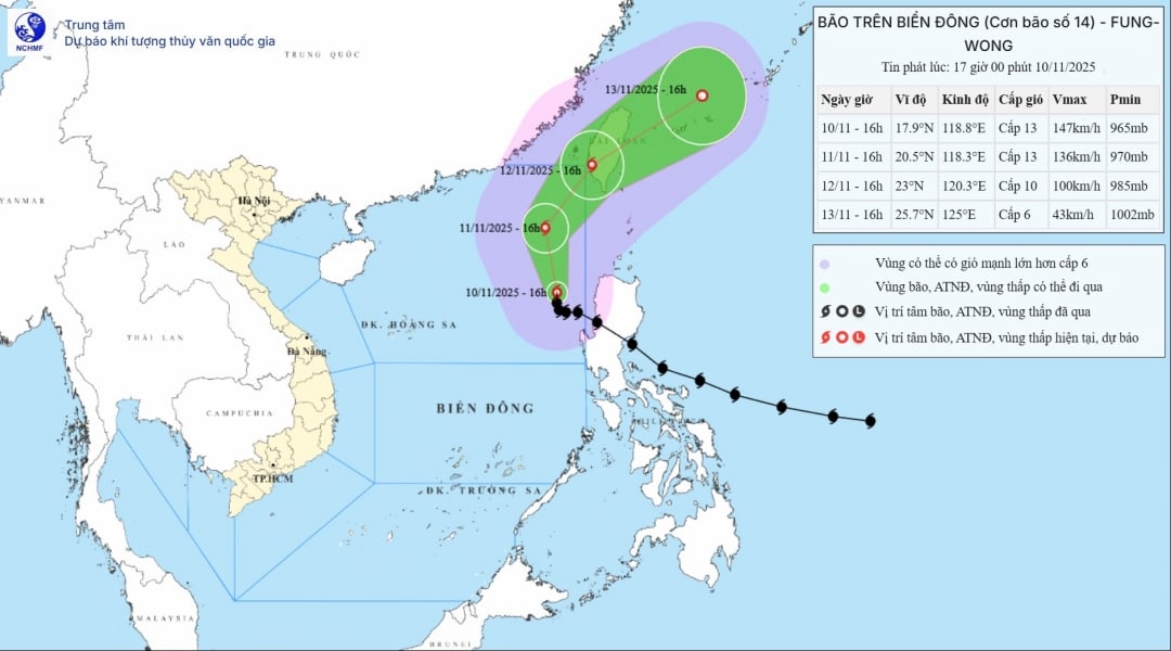 |
| Map of location and direction of storm No. 14 posted at 5:00 p.m. on November 10. |
To proactively respond to storm developments, the Department of Agriculture and Environment recommends that localities and units continue to seriously implement the directives and plans on prevention, control and overcoming damage caused by natural disasters in 2025 that have been issued.
The Department of Agriculture and Environment requests the Provincial Border Guard Command, Phu Yen Coastal Information Station, the Department of Fisheries and Islands, and the Fishing Port Management Board to closely coordinate with coastal localities to promptly and fully inform captains and owners of vehicles and boats operating at sea about the location and direction of storm No. 14.
In addition, the Provincial Hydrometeorological Station, Provincial Newspaper, Radio - Television and mass media agencies: regularly update and strengthen information about storm No. 14 and dangerous areas to authorities and people at all levels to proactively prevent and respond promptly and effectively.
Localities and units must organize disaster prevention and control on duty according to regulations.
Source: https://baodaklak.vn/kinh-te/202511/thong-tin-kip-thoi-cho-cac-phuong-tien-tau-thuyen-dang-hoat-dong-tren-bien-ve-bao-so-14-42f13a7/
![[Photo] Prime Minister Pham Minh Chinh attends the annual Vietnam Business Forum](https://vphoto.vietnam.vn/thumb/1200x675/vietnam/resource/IMAGE/2025/11/10/1762780307172_dsc-1710-jpg.webp)


![Dong Nai OCOP transformation: [Article 4] Reaching national standard products](https://vphoto.vietnam.vn/thumb/402x226/vietnam/resource/IMAGE/2025/11/11/1762825820379_4702-cac-san-pham-trai-cay-chung-nhan-ocop-nongnghiep-174649.jpeg)


![Dong Nai OCOP transition: [Article 3] Linking tourism with OCOP product consumption](https://vphoto.vietnam.vn/thumb/402x226/vietnam/resource/IMAGE/2025/11/10/1762739199309_1324-2740-7_n-162543_981.jpeg)


Comment (0)