
If you are planning to visit Ha Giang , the following lines from experience and practical experience will hopefully help you have the most meaningful and complete journey.

Road to Meo Vac - Photo: MINH HUYEN
Ha Giang tourism is gradually regaining its form, especially from this fall to the end of next spring. Southern tourists go to the North to enjoy the typical cold air, change the scenery in their vision and experience the unique cultures of the Northeast - where each stone sings a song in the middle of the forest.
The following complete itinerary around the West of Ha Giang will help you feel more confident about your upcoming journey.
Day 1: Ha Giang - Quan Ba Heaven Gate - Yen Minh - Tham Ma Slope - Nha Vuong - Dong Van (about 100km)

Quan Ba Heaven Gate - Photo: MINH HUYEN
Get on the bus at My Dinh bus station ( Hanoi ) at 7pm, you will arrive in Ha Giang city early the next morning, just have a good night's sleep.
In the city center, there are many motels and hotels that offer motorbike rental services with helmets. A heat patch on your back, the neatest luggage that can be tied tightly to the back of the bike, warm and comfortable clothes, sneakers, gloves, windshield, full identification, and you are ready to conquer the stone plateau.
The first stop is Quan Ba Heaven Gate , after winding curves and increasing altitude. The wind is howling, the temperature drops, only about 5 degrees Celsius. At this time, many people start to wear warm clothes, scarves, neckerchiefs and gloves. A cup of coffee or hot cocoa here cannot maintain the temperature for 3 minutes. Take a sip and look far away, watching the majestic natural scenery below, feeling so small but the soul is spread out among the mountains and forests.

Lonely tree - Photo: MINH HUYEN
From Quan Ba to Yen Minh, the group stopped at the lonely tree on Highway 4C in Can Ty commune. This is one of the most precious ironwood trees being preserved. Not every group of vehicles can find this majestic tree leaning over the abyss without a local person showing them the way.

Tham Ma Slope - Photo: MINH HUYEN
Stop for a moment at Tham Ma slope to admire the spectacular pass that the convoy has just passed before stopping at Pao's House and Vuong's Palace. In the past, this slope was used to test the strength of the strongest horses, but is now a popular sightseeing spot for tourists.
When the afternoon sun shines through the mountain crevices, the cheeks of the ethnic child squinting his adorable single eyelids turn pink, creating an innocent and bright picture. A few clear sounds from the flute and panpipe of the boys on the mountainside also make visitors listen for a long time.

King Meo's Palace - Photo: MINH HUYEN
The Vuong Palace , also known as the residence of the Meo King, Vuong Chinh Duc - an architectural work with the breath of Mong - French - Chinese culture, was started in 1898 and took 9 years to complete. This is where you will witness the royalty of a highland family with a campus of more than 3,000m2 including many solidly built houses with many sophisticated details.
Around 5pm, you should depart for Dong Van to avoid the dark, and having a hot pot meal around 7pm is perfect for the first day.
Day 2: Dong Van - Lung Cu - Ma Pi Leng Pass - Nho Que River - Meo Vac (about 95km)

Road to Meo Vac - Photo: MINH HUYEN
Completing the second day of the route is a spectacular experience in this journey when successfully conquering Ma Pi Leng , one of the "four great mountain passes of Vietnam" and Nho Que River, likened to a soft jade green thread descending from the sky.
If you are lucky, you can attend the market in the center of Dong Van town, immerse yourself in the joyful atmosphere, bustling with buyers and sellers, and enjoy the specialties of the mountainous plateau. People from everywhere carry baskets to the market. They sell food, home-grown vegetables such as pigs, chickens, ducks, cabbage, herbs, medicine, spices, etc. to exchange for other necessities.

Central market - Photo: MINH HUYEN
Have breakfast at the market and enjoy buckwheat coffee in Dong Van old town, then prepare to depart for Lung Cu. The northernmost point and Lung Cu flagpole are two different locations that many people often mistake as one. These two attractions are about 3km apart. The northernmost point has a viewing platform, from here you can look to the Chinese border . The road to the northernmost point is being renovated, but the scenery from the cliff looking to the border is also very poetic and beautiful.

Lung Cu Flagpole - Photo: MINH HUYEN
Lung Cu Flagpole brings a sacred feeling when the love for homeland and country seems to converge at a crimson point. A souvenir photo at the national flagpole is an indispensable part of this stop.
The morning of pride will be followed by the majesty of the great forest with a winding road hugging the legendary Ma Pi Leng Pass and heading straight to Nho Que River. Driving on the pass requires health, concentration and manual transmission skills, so the advice is not to skip any main or side meals of this journey.

Tu San Alley overlooking Nho Que River - Photo: MINH HUYEN
Stopping at Tu San alley to see Nho Que river from above between two deep gorges is a recommended photo spot. However, you need to know the exact coordinates or be guided by a local to avoid going too far.
It is reasonable to arrive at Nho Que river wharf after 3pm. You can watch the last rays of sunlight on the mountainsides on both sides of the river. The shuttle bus will take you to the wharf and then cruise on the river for about 1 hour.
The river water is clear, calm and a deep blue, so magical that only nature can create this wonderful color. The boat will stop at the most beautiful spot, right next to the river and the mountain, for tourists to take pictures. This scene is also a "must-take" when coming to Ha Giang.
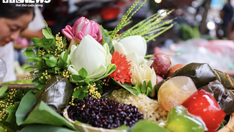
At the end of the second day, the Mong ethnic community cultural tourism village will be the resting place that night. Small homestays light up to welcome guests and prepare trays full of local specialties. The most prominent is still the light purple sticky rice, the rice grains are large, sticky, fragrant and sweet, eaten with sesame salt, chicken, and roasted pork, all delicious.

Sticky purple sticky rice and sticky rice with gac fruit - Photo: MINH HUYEN
In the evening, you can walk around the village, enjoy hot coffee, tea and sit around the fire in the cold weather. A few sweet potatoes, sugar cane or corn buried in the warm fire will also make your stories sweeter and your sleep more restful.
Day 3: Meo Vac - Mau Due - Du Gia (about 100km)

Mau Due road is being repaired - Photo: MINH HUYEN
Two days of driving is tiring but will quickly disappear with what you get from Ha Giang. The road from Meo Vac to Mau Due is being renovated for a stretch of more than 20km, so you need to focus on driving safely.
This route is famous for the "M" shaped pass that you must definitely see from above and breathe the cool air. At this point, the bumpy road is over. People say the letter "M" is Meo Vac, which means "luck", "clear-headed" and can also mean "money", all good things so everyone took the opportunity to take souvenir photos.

The legendary M-shaped pass - Photo: MINH HUYEN
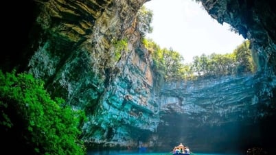
After stopping for lunch, the group continued to set out to find Du Gia waterfall , which has water flowing all year round. The waterfall is over 5m high and about 3m wide, with clear, cool water pouring down from above, forming a small, babbling stream that allows you to clearly see the rocks below.
Located on provincial road 176 in Tien village, Du Gia commune, Yen Minh district, it will be very difficult for you to find this waterfall, so you have to ask for directions continuously or have a tour guide. The trail is about 4km long leading to the waterfall, passing through residential areas, winding between villages and is very bumpy, so you need to have a steady hand on the wheel or walk if you are not confident.

Du Gia Waterfall is hard to find but extremely worth your effort - Photo: MINH HUYEN
If the weather is not too cold or sunny, many tourists, especially foreigners , love to soak in the clear blue water like this. Surrounded by mountains, rocks, wild grass and trees, quiet only the sound of pure flowing water can be heard. The scenery is truly touching.
In Du Gia, there are many unique wooden homestays open to welcome guests, so you don't have to worry much about accommodation. The hosts are all locals and very warm. The feeling of closeness and peace will make you want to stay for a long time.
Day 4: Du Gia - Duong Thuong - Lung Tam - Ha Giang (about 110km)

Beautiful handmade products - Photo: MINH HUYEN
The final leg of the journey to conquer Ha Giang will pass through Lung Tam to learn about the famous linen weaving craft of the Mong people. The finished linen fabric must go through 41 meticulous manual stages. On the banks of the Mien River, women and mothers still diligently preserve this traditional craft every day, both to make clothes for themselves and to introduce tourists to a unique local craft.
It is said that the linen fabric here is durable against sun, rain, and harsh weather. It is cool in summer but also keeps you warm in winter. The colors are colorful and bright, so the Mong people still love and cherish their clothes.

Linen weaving in Lung Tam - Photo: MINH HUYEN
Arriving at the center of Ha Giang city around 4pm, the whole group should take a photo together at the 0km milestone. It's a bit counterintuitive, but taking a photo at this milestone at the end of the journey really brings a feeling of calmness and nostalgia when thinking about the 4-day journey that received so much precious love from Ha Giang. Perhaps this is a promise for you to return to this city one day in the near future.
Hopefully, the sharing from real experiences in 4 days traveling Ha Giang by motorbike will help you have more information and best preparation for a complete journey.
Tuoitre.vn


Comment (0)