
During the long 30/4 - 1/5 holiday, many tourists choose trekking - a form of tourism that combines discovery with physical training and connecting with nature. Below are suitable trekking routes for a 2-3 day journey from major cities, suggested by Mr. Nhat Minh, a tour guide in Ho Chi Minh City, and surveyed by VnExpress reporters.
Ta Lien Son, Lai Chau
Ta Lien or Co Trau Mountain is located in Ta Leng Commune, Tam Duong District. The mountain is 2,993 m above sea level and is among the highest peaks in Vietnam.
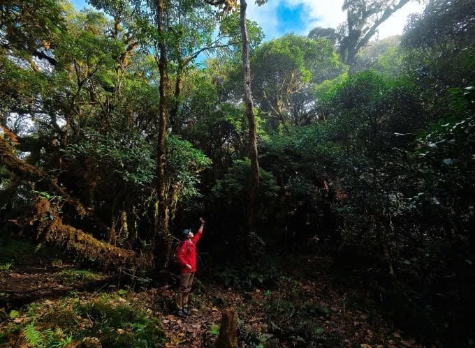
Ta Lien Range impresses with its primeval vegetation including ancient trees with wide canopies, camellias, red maple leaves and a long green moss carpet. The space of the mountain top is like a fairy forest. However, Ta Lien's terrain is relatively complex, visitors should not experience it on their own to avoid getting lost. It is recommended to register for a group tour to receive support during the trekking process such as a guide showing the way, providing information, a porter providing food, and luggage support if needed.
Pha Luong Peak, Son La
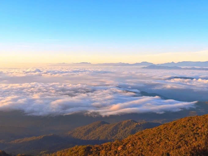
30 km from Moc Chau town, Pha Luong peak is located between the Vietnam - Laos border, over 2,000 m high, considered the roof of Moc Chau.
Visitors can experience trekking to the top here, the time from Pha Luong border post to the top is about 3 - 4 hours. The Pha Luong climbing route has many beautiful scenes but is dangerous because of many rocky slopes, narrow trails winding through ravines, visitors need to learn and prepare carefully before climbing.
The 360-degree view of the floating sea of clouds is a "reward" for visitors when reaching the top of Pha Luong on days with favorable weather. Visitors should pay attention to safety when playing on the cliff, and should not be too adventurous to take pictures.
Nui Chua, Ninh Thuan
Chua Mountain is located in Thai An village, Vinh Hai commune, Ninh Hai district. The two highest peaks on the range are Co Tuy (locally called Chua Anh peak, 1,039 m high) and Ong mountain (also known as Chua Em peak, 978 m high). Chua Mountain has a typical dry climate, with one of the lowest rainfall levels in Vietnam. It is a place chosen by many tourists for trekking to "challenge their limits".
The total trekking journey to Nui Chua is 25 km, suitable for a weekend trip with a 2-day-1-night schedule. Starting from the gate of Nui Chua National Park, the first stop is Am Du Lake, the "sacred lake" of the Raglai community and a freshwater lake that supplies water to villages in Vinh Hai commune. Visitors cross grassy hills, streams, and climb continuously to reach the top and set up tents overnight at O Liem stream. From the top of Nui Chua, 1,093 m high, visitors can admire the majestic mountains, hunt for clouds and welcome the sunrise early the next morning.
The landscape of Chua Mountain is different from other places. At the foot of the mountain is a burning sand beach and in the distance are vast fields of cogon grass. After passing the grass layer, visitors will reach the thorn layer, which is a layer of thorny bushes, growing in diverse shapes like bonsai to adapt to the drought.
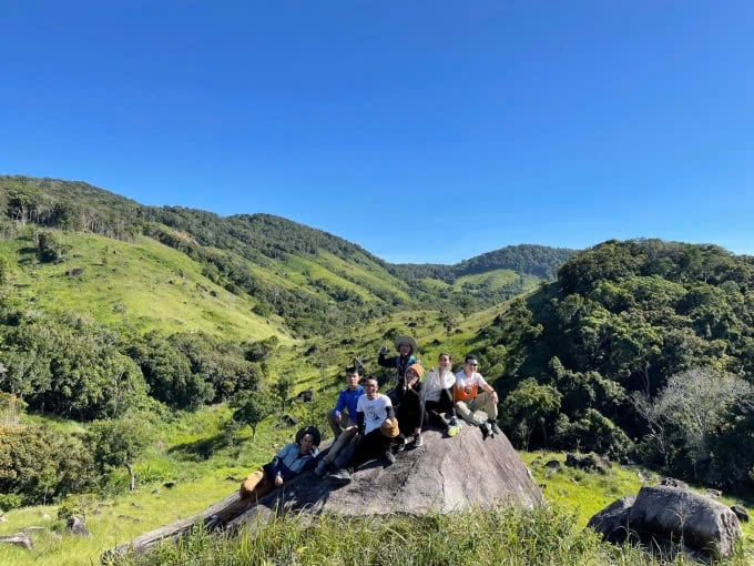
Ta Giang, Khanh Hoa
The trekking route goes from Thanh Son commune, Khanh Son district to Son Thai commune, Khanh Vinh district with a route of about 22 km, taking 2 days and 1 night to complete. The Ta Giang trekking terrain goes through green grasslands and flat stone streams, without many steep slopes, suitable for first-time trekkers.
The ideal time to explore this area is from February to September. From October to December is the rainy season, the river water rises, making it inconvenient to travel. The journey along the Khe River - the border between Ninh Thuan and Khanh Hoa leads visitors through trails, many sections require wading through streams or walking on slippery rocks, requiring careful observation. Along the first 6 km of the journey, there are clear streams, many sections form natural lakes for visitors to rest and cool off.
Although this route is easy to go, new trekkers should still practice to have good health and flexibility because they will have to climb mountains and wade through streams.
Chu Mu, Dak Lak
The mountain is located in Ea M'Doal commune, M'Drak district, close to the border of Khanh Hoa province, at an altitude of about 2,000 m. The range has two high peaks, locally called Hon Vong Phu or "mother and child mountain". From here, visitors can admire the majestic scenery of three provinces: Khanh Hoa, Phu Yen and Dak Lak.
The journey to conquer the mountain peak is about 30 km long, walking through the forest. The first 500 m is quite flat and easy to walk. However, the section from Bay waterfall becomes more difficult, visitors have to climb continuously. Those who go for the first time should not go alone, need to go with someone experienced or hire a local to guide.
Tourists can form small groups, hire a guide for about 400,000 - 500,000 VND (day trip), or register for a 3-day, 2-night trekking tour, costing about 4-5 million VND for a group of 4-5 people.
According to vnexpress.net
Source: https://baohanam.com.vn/du-lich/5-cung-trekking-tranh-dam-dong-dip-30-4-158236.html
![[Photo] The moment Harry Kane lifted the Bundesliga trophy for the first time](https://vphoto.vietnam.vn/thumb/1200x675/vietnam/resource/IMAGE/2025/5/11/68e4a433c079457b9e84dd4b9fa694fe)


Comment (0)